
Île aux Benitiers
| Île aux Benitiers | ||
|---|---|---|
.jpg) |
||
| Waters | Indian Ocean | |
| Geographical location | 20 ° 25 '8 " S , 57 ° 20' 38" E | |
|
||
| length | 2 km | |
| width | 500 m | |
| surface | 65 ha | |
| Residents | uninhabited | |

The Ile aux Bénitiers is one of the coast's largest district in the country Black River upstream island in the southwest of Mauritius .
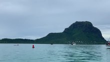
The island, formed from coral sand, is two kilometers long in north-south expansion, a maximum of 500 meters wide, has a size of 65 hectares and is located about 500 meters off the coast of La Gaulette a few kilometers north of the Morne Brabant peninsula .
A luxury hotel project is planned on the previously uninhabited island, which, like other tourist businesses in the area, will take advantage of the relative lack of rainfall in the south-west of Mauritius.
Individual evidence
Web links
- Description of the Île aux Bénitiers on iels.intnet.mu
- http://www.pbase.com/bolla49/image/36339246 Photo from the Piton de la Petite Rivière Noire (828 m), the highest mountain in Mauritius