
Île d'Or
| Île d'Or | ||
|---|---|---|
 |
||
| Waters | Mediterranean Sea | |
| Geographical location | 43 ° 24 '39 " N , 6 ° 50' 47" E | |
|
||
| length | 190 m | |
| width | 90 m | |

The Île d'Or (in German "Goldinsel") is located in the Mediterranean in the Provence-Alpes-Côte d'Azur region in the Var department in front of the Côte d'Azur , geographically it belongs to Saint-Raphaël and is clearly visible in front of the beach Le Dramont . The closest town is Agay in the north (3 kilometers).
The island is about 190 meters long and about 75 to 90 meters wide, has a rocky bottom and a prominent tower in the middle that serves as an apartment. This tower was built in 1912 from island stones blasted on site by dynamite. Before this explosion, the island was uninhabited. To the east there is a steep rock face with a landing that cannot be climbed. In other places you can get anywhere on the island.
To the west of the island there are many yachts moored during the day and also at night.
The Île d'Or has its tip turned towards the beach. It is privately owned, so landing on the island is undesirable for the owners. This can be reached by boat or by swimming. Right on the shore, only 450 meters away, is the large campsite Campeole le Dramont , from which the island is clearly visible.
During the Second World War on August 15, 1944, the Allied troops (36th Division from Texas) landed on the beach of Le Dramont, directly in front of the island .
The rocky coast towards Agay is a popular destination for kayakers , divers and rock jumpers. The steep cliffs around Mount Dramont offer deep and transparent jumping points.

Rock jumps near the island
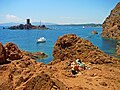
View of the island from the Dramont rock

Island at sunset
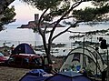
Island seen from the campsite

Île d'Or - frontal


Individual evidence
Web links
- Pictures of the island (French)
- Website of Il d Or (French)