Île de Fadiouth
| Île de Fadiouth | ||
|---|---|---|
| Bridge from Joal to Fadiouth Island | ||
| Waters | Mamanguedj lagoon | |
| Geographical location | 14 ° 9 ′ 9 ″ N , 16 ° 49 ′ 24 ″ W | |
|
|
||
| length | 725 m | |
| width | 430 m | |
| surface | 15 ha | |
| Residents | 9000 60,000 inhabitants / km² |
|
| The neighboring cemetery island of Diotyo | ||
The Île de Fadiouth is one of three mussel islands in the West African state of Senegal . It is located about 114 kilometers south of the capital Dakar and belongs to the city ( commune ) Joal-Fadiouth in the department of Mbour , Thiès region .
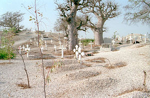
The second of the three shell islands is the cemetery island of Diotyo, 185 meters northwest. A third island was used as a storage island. The mussel islands were created artificially when 1500 years ago people began to throw mountains of mussel shells into the shallow Wadden Sea of the Mamanguedj lagoon.
Of the 39,078 residents of the parish (2007 estimate), more than three quarters are in the parish capital of Joal and the remainder in Fadiouth. With over 9,000 inhabitants on around 15 hectares , Fadiouth is one of the most densely populated islands on earth.
The island is connected to the village of Joal by an 800 meter long wooden footbridge .
Fadiouth is divided into six districts ( quartiers ):
- Ndonguème (north)
- Ngor Deb (Southwest)
- Ndoffène (northeast)
- Fassar (northwest)
- Ndiandiaye (West)
- Dioum (south)
See also
Individual evidence
- ↑ GEO travel community: Travel tip: Shell Island
- ↑ îles . calouan.hautetfort.com. January 15, 2008. Retrieved May 28, 2012.


