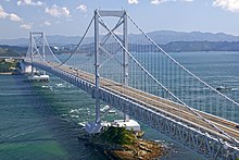
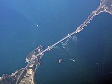
Ōnaruto Bridge
The Ōnaruto Bridge ( Japanese 大 鳴 門橋 Ō-Naruto-kyō ; Eng . "Great Naruto Bridge") is a 1,629 m long suspension bridge over the Naruto Strait between Minami-Awaji on Awaji-shima and Naruto on Ōge-jima . It is supplemented by the Konaruto Bridge ("small Naruto Bridge") and Muya Bridge between Ōge-jima and Shikoku .
Construction of the bridge began in September 1976, and on June 8, 1985 it was opened to vehicle traffic. This replaced all previous ferry connections between the two islands; since then there has been no connection between Awaji-shima and Shikoku for pedestrians, cyclists and small cars (up to 3.4 m in length, 660 cm³).
The main span of the bridge is 876 m, the side spans each 330 m, as well as 93 m in the north, the width of the bridge 25 m and the height of the pillars 144 m. Designed as a combined motorway and railway bridge, it was built on two floors. The Akashi-Kaikyō-Bridge from Awaji-shima to Kobe , which was then built from 1986 to 1998, was planned from the outset exclusively for road traffic and therefore only one-story. Using the bridge connection from Honshū via Awaji-shima to Shikoku for the Shinkansen now appeared to be inexpedient, as the noise on the lower level of the bridge forbade passage at more than 70 km / h and, with the frequent strong winds, the train traffic on the suspension bridge even stops Safety reasons must be set in each case (a general speed limit of 70 km / h applies to road traffic on the bridge, and 40 km / h on windy days).
After saying goodbye to the railway connection, the lower level of the Ōnaruto Bridge, which was no longer needed, was converted into the Naruto Whirlpool Mile as part of Naruto Park , which attracts many visitors.
Of the three bridges between Honshū and Shikoku, the Ōnaruto Bridge was the busiest with 6.8 million vehicles in 2004 after the Akashi-Kaikyō Bridge, which was also part of the Kobe-Awaji-Naruto highway. The figures have reached the original cost plans of the deficit Honshū Shikoku Bridge Society since opening, however, only to 78%.
Web links
Coordinates: 34 ° 14 ′ 18 ″ N , 134 ° 39 ′ 1 ″ E


