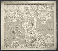
Accurate situation card from a part of the Electorate of Saxony

from Wikipedia, the free encyclopedia

The Accurate Situations-Carte Von Eine Part des Churfürstenthums Sachsen is a set of maps by Isaak Jakob von Petri and Johann David Schleuen . It dates from 1762. It shows the area around Dresden in the Electorate of Saxony . It was created during the Seven Years' War .

The full title reads: “Accurate Situations-Carte of a part of the Electorate of Saxony, and mainly of the areas 4 to 5 miles from the center around the capital and residence city of Dresden: in which all mountains and valleys, lakes and ponds, rivers , Rivers and streams with all the morasses, meadows, woodlands and forests attached to them, likewise the locations of the villages with all the country roads and other common village paths going through and alongside them, no less all individual houses as foremen, sheep farms, forest and winegrowers' houses, inns and Taverns, brickworks, pitch and tar huts, also wind and water mills, precisely noted according to their essential and natural location, and in such a way these areas are taken up for the use and benefit of the Royal Prussian Army, put in a true light, and according to the below Quite a large measure in the years of the present war 1759 and 1760 brought and recorded in this clear map net by the ingen. Major Petri and some Prussian Ingen. Officiers ... also afterwards by the same in the following campaigns in 1761 and 1762 in those places where one could not come before the enemy, was completely improved and made complete. "

It was followed by the Accurate Situations- and Cabinets-Carte from another part of the Electorate of Saxony .

The map series is available from the Leibniz Institute for Regional Geography .

Card cut

Accurate Situations-Carte Of A Part Of The Electorate Of Saxony, And Mainly From The Areas 4 To 5 Miles From The Centro To The Main And Residence City Of Dresden 02.jpg
Accurate Situation-Carte Of A Part Of The Electorate Of Saxony, And Mainly From The Areas 4 To 5 Miles From The Centro To The Main And Residence City Of Dresden 03.jpg
Accurate Situations-Carte Of A Part Of The Electorate Of Saxony, And Mainly From The Areas 4 To 5 Miles From The Centro To The Main And Residence City Of Dresden 04.jpg
Accurate Situations-Carte Of A Part Of The Electorate Of Saxony, And Mainly From The Areas 4 To 5 Miles From The Centro To The Main And Residence City Of Dresden 05.jpg
Accurate Situations-Carte Of A Part Of The Electorate Of Saxony, And Mainly From The Areas 4 To 5 Miles From The Centro To The Main And Residence City Of Dresden 06.jpg
Accurate Situations-Carte Of Part Of The Electorate Of Saxony, And Mainly From The Areas 4 To 5 Miles From The Centro To The Main And Residence City Of Dresden 07.jpg
Accurate Situations-Carte Of A Part Of The Electorate Of Saxony, And Mainly From The Areas 4 To 5 Miles From The Centro To The Main And Residence City Of Dresden 08.jpg
Accurate Situations-Carte Of A Part Of The Electorate Of Saxony, And Mainly From The Areas 4 To 5 Miles From The Centro To The Main And Residence City Of Dresden 09.jpg
Accurate Situations-Carte Of A Part Of The Electorate Of Saxony, And Mainly From The Areas 4 To 5 Miles From The Centro To The Main And Residence City Of Dresden 01.jpg
Accurate Situations-Carte Of Part Of The Electorate Of Saxony, And Mainly From The Areas 4 To 5 Miles From The Centro To The Main And Residence City Of Dresden 10.jpg
Accurate Situation-Carte Of A Part Of The Electorate Of Saxony, And Mainly From The Areas 4 To 5 Miles From The Centro To The Main And Residence City Of Dresden 11.jpg
Accurate Situations-Carte Of Part Of The Electorate Of Saxony, And Mainly From The Areas 4 To 5 Miles From The Centro To The Main And Residence City Of Dresden 12.jpg

See also

Web links