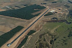
Aeródromo de Soria-Garray
| Aeródromo de Soria-Garray | |
|---|---|

|
|
| Characteristics | |
| ICAO code | LEGY |
| Coordinates | |
| Height above MSL | 1036 m (3399 ft ) |
| Transport links | |
| Distance from the city center | 8 km north of Soria |
| Street | N-111 |
| Basic data | |
| opening | 2004 |
| surface | 90 ha |
| Runways | |
| 09/27 | 1357 m × 23 m asphalt |
| 02/20 | 492 m × 18 m asphalt |
The Aeródromo de Soria Garray is an airfield in the general aviation in the Spanish province of Soria in the northern part of central Spain. It is located in the municipality of Garray, around three kilometers west of the city of Garray, near the N-111 national road.
The airfield, which was built in 2003 and opened in 2004, with an area of 90 hectares is approved according to the rules for visual flights (VFR) for aircraft up to a total weight of 22 tons and helicopters and has two paved runways.
In addition to the hangar , the tower, a gas station with AV GAS 100 LL and the facilities of the flight school Escuela de Formación Aeronáutica AIRMAN as well as a restaurant are located on the airport premises . The operator is Airpull Aviation .
The tower frequency of the controlled airfield is 123,500 MHz .
Trivia
The Spanish military uses this airfield for training flights with machines of the type CASA C-295M . In August 2008, the airfield was the venue for the Copa Triangular de Vuelo Acrobático (CTVA), an aerobatic competition with historic machines.