Agrafiotis
|
Agrafiotis (Αγραφιώτης) |
||
|
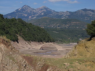
Manoli Bridge at low tide of Agrafiotis and Kremasta Lake |
||
| Data | ||
| location | Greece , Central Greece , Evrytania | |
| River system | Acheloos | |
| Drain over | Acheloos → Ionian Sea | |
| source | Deldimi (Agrafa Mountains) | |
| Source height | approx. 2000 m | |
| muzzle |
Kremasta Lake ( Acheloos ) Coordinates: 38 ° 58 ′ 21 ″ N , 21 ° 33 ′ 28 ″ E 38 ° 58 ′ 21 ″ N , 21 ° 33 ′ 28 ″ E
|
|
| length | 58 km | |
| Left tributaries | Asprorema, Direma | |
| Right tributaries | Marisiotis, Seliotiko, Melissorema, Kouatesos | |
The Agrafiotis ( Greek Αγραφιώτης or Agrafiotikos Αγραφιώτικος) is a 50 to 58 km (depending on the source) long river in the regional district of Evrytania in the region of Central Greece in Greece . It runs from north to south and flows into Lake Kremasta .
The name Agrafiotis is derived from the headwaters of the river, the Agrafa Mountains, part of the southern Pindos Mountains. The Agrafiotis rises on the one hand as Trovatiano Rema (Τροβατιανό ρέμα) from the eastern flank of the Deldimi massif ( 2126 m summit height) west of the village of Trovato and initially flows to the south-east and north past Trovato. West of Trovato, the tributary Koustesos flows from the north into the Trovatiano Rema. After this confluence, the Trovatiano Rema continues in a southerly direction in a narrow valley with many bends and receives the tributary of the Direma from the Gennitsari mountain ( 1789 m ) from the west . A little further south of it, the river Vrangianitiko Rema (Βραγγιανίτικο ρέμα) flows from the village of Vrangiana and the Katarachias mountain ( 2002 m ) with the Trovatiano Rema.
After this confluence of the western source river (Trovatiano Rema) and the eastern source river (Vrangianitiko Rema) at the Dendrou Vrangianon bridge, the river is called Agrafiotis. The further course of the river continues unchanged to the south in a narrow valley between the mountains Kafki in the west ( 1607 m ) and Itamos Agrafon ( 1405 m ) and Koukourontzos ( 1720 m ) to the tributary of the Asprorema coming from the north-west. East-northeast of the Kafki and south of the Itamos, the Valaritiko Rema flows into the Agrafiotis from the east. When you pass the Kafki mountain, the town of Tridendro is also flown around to the east. South of Tridendro, the Samari stream flows into the Agrafiotis from the west.
After the confluence of the Asprorema in the Agrafiotis at Agii Theodori, the Tsouma mountain ( 1518 m ) flows around in its east. On the eastern slopes of this mountain lies the village of Epiniana near the Agrafiotis. East of the Agrafiotis at the same height is the village of Agrafa , the administrative seat of the municipality of Agrafa . The Smbororema (Σμπορόρεμα) flows through Agrafa, which flows into the Agrafiotis near Paramerita. From Paramerita the gorge-like section of the Agrafiotis valley begins, which is known as the Tripa Agrafioti gorge . When entering this, the Agrafiotis swings to the southwest and runs along the southeast and eastern flanks of the Tsouma Mountain to the tributary Fteris, which comes from the eastern side of the highest peak of the western Agrafa Mountains, the Fteri ( 2126 m ), in a pointed direction Angle flowing into the Agrafiotis. At the inflow of the Fteris there is a bridge from Ottoman times over the Agrafiotis, the Aniforas Bridge.
In the narrow valley between the mountains Koftra ( 1505 m ) in the east and Gravani ( 1713 m ), an eastern branch of the Liakoura ( 2040 m ), in the west the Agrafiotis river runs south. Before the village of Karvasaras, the Myrisiotis flows into the Agrafiotis from the east. At the same time there is the Ottoman Karvasara bridge at this tributary confluence. The Agrafiotis turns sharply to the west around the foothills of the Katsandoni and runs east of the Pyramida mountain ( 1345 m ) to the village of Varvariada. In this course it receives the tributary Monastirakiotiko Rema from the west, which runs through the village of Monastiraki. After the influx of the rivers Seliotiko and Melissorema from the east, the Agrafiotis swings at the village of Kleftolimero to the southwest towards the village of Tsouka. East of Tsouka is the Manoli Bridge from 1659, which leads or led over the Agrafiotis.
With the damming of the Acheloos to the Kremasta Lake from 1967, the old confluence of the Agrafiotis in the Acheloos disappeared further south. Rather, a branch of the Kremasta Lake extends to the Manoli Bridge and beyond to the north (approx. 2 km). The expansion takes place according to the water level and can lead to a complete disappearance of the Manoli Bridge in the event of high water. When the tide is low, the Manoli Bridge can stand on dry land.
The course or the valley of the Agrafiotis serves to differentiate between the western and the eastern part of the Agrafa Mountains.
Web links & sources
- Άγραφα / Mt. Agrafa Map. 1: 50,000. Road Editions, Athens. ISBN 960-8481-99-6
- Agrafiotis on the GTP Travel Pages (in English and Greek)
- Information on the Agrafiotis River in the municipality of Agrafa (in Greek)
