
Aiguilles de Bavella
| Aiguilles de Bavella | ||
|---|---|---|
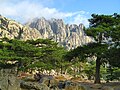
 View of the mountain range from Zonza |
||
| Highest peak | Punta Alta ( 1855 m ) | |
| location | Corsica , France | |
|
||
| Coordinates | 41 ° 49 ' N , 9 ° 13' E | |
| rock | granite | |

The Aiguilles de Bavella (German: Bavella needles) are a mountain range on Corsica in the Corse-du-Sud department . The very distinctive granite towers reach a height of up to 1855 m and belong to the northern group of the Bavella massif, which lies between the massif of Monte Incudine in the north and the Alta Rocca area in the southwest.
The 7 Bavella towers (on the picture from right to left):
| No. | Surname | height |
|---|---|---|
| I. | Punta di l'Acellu | 1588 m |
| II | Punta di l'Aariettu | 1597 m |
| III | Punta di a Vacca | 1611 m |
| IV | Punta di u Pargulu | 1785 m |
| V | Punta Longa | 1836 m |
| VI | Punta Alta | 1855 m |
| VII | Punta Lolla | 1848 m |
The only pass road through the Bavella massif is the Col de Bavella . Hiking trails to the Aiguilles are marked from the top of the pass ( 1218 m ). The GR20 leads south past the rock needles, the alpine variant of the GR20 leads up to the peaks. Tower III is generally considered to be relatively easy to climb and offers a magnificent view.

Popular postcard motif: The small town of Zonza in front of the Aiguilles de Bavella
The Aiguilles from the Col de Bavella

In the Aiguilles


particularities
The locals also call the mountain peaks Fourches (forks) or Cornes d'Asinao (donkey ears).
literature
- Klaus Wolfsperger: Corsica, the most beautiful coastal and mountain hikes , Bergverlag Rother, Munich, ISBN 978-3-7633-4280-8