
Col de Bavella
| Col de Bavella | |||
|---|---|---|---|
 View of the top of the pass (1218 m) |
|||
| Compass direction | Northeast | southwest | |
| Pass height | 1218 m | ||
| Department | Corse-du-Sud | ||
| Valley locations | Sari Solenzara | Zonza | |
| expansion | Pass road | ||
| Mountains | Bavella massif, Corsica | ||
| map | |||
|
|||
| Coordinates | 41 ° 47 '45 " N , 9 ° 13' 28" E | ||

The Col de Bavella is a mountain pass in the Corsica Regional Nature Park . The D 268 leads over it from Sari-Solenzara to Zonza and on to Sartène . The pass road is considered to be one of the most scenic routes on the island.
The pass, which is 1218 meters high, is a starting point for extensive hikes and climbing tours in the Bavella massif. A hiking trail leads south to Trou de la Bombe (English: bomb crater), a huge hole in a rock face. In the northwest are the impressive granite rocks Aiguilles de Bavella . The GR20 hiking trail leads over the Col de Bavella and south past the rocky peaks. The alpine variant of the GR20 offers a somewhat more demanding climbing tour through the rocky landscape and up to the peaks.
At the edge of the road on the top of the pass is the statue of Our Lady Notre Dame de la Neige , which is supposed to protect against dangers in the mountains. Every year at the beginning of August a pilgrimage (pélerinage) takes place there.
Below the Col de Bavella in the direction of Solenzara, guided canyoning tours are offered in the Canyon de la Purcaraccia and Canyon de la Pulischella gorges .
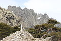
Aiguilles de Bavella with statue Notre Dame des Neiges

View from the Col de Bavella

Trou de la bomb
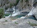
Canyon de la Purcaraccia

Pine at Col de Bavella

Looking east

.jpg)


literature
- Jean B Carillet, Miles Roddis, Neil Wilson: Corsica, 40 tours and hikes , Lonely Planet, Ostfildern, ISBN 978-3-8297-2203-2
- Walter Eckel, Reina Eckel, Thomas Eckel: Corsica, easy mountain hikes Volume 1: Bavella , Books On Demand, ISBN 978-3-8423-7068-5