al-Harra
The village of al-Harra ( Arabic الحارة al-Harra , the hot [village] ') is located about 25 km east of the city of al-Bawīti in the sink al-Bahariya in Egypt . The rock inscriptions from the ancient Egyptian 12th Dynasty found near the villagerepresent an important link in the settlement history of the western desert of Egypt.
Location of the village
The village is located south of the trunk road from al-Bāwīṭī to Cairo . In 1980, around 800 people lived in 180 households. In addition to the main hamlet al-ʿAyn al-ǧadīda ("the new spring"), al-Ḥārra has six other well markings. The inhabitants cultivate around 600 feddān (250 hectares) of land on which around 8,000 palm trees grow. The water comes from three deep wells and 21 "Roman", ie old wells.
Naming
The name al-Ḥārra means "the hot [village]". The village is surrounded on all sides by high limestone cliffs containing fossils ; there are only gaps along the trunk road. The wind, which otherwise cools the whole valley down, blows over the village.
Rock inscriptions of the 12th dynasty
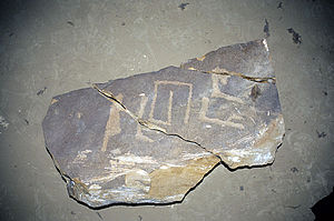
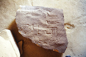
In 1973, Ahmed Fakhry (1905–1973) discovered three rock inscriptions from the Middle Kingdom near the village . In 2001, the Institut français d'archéologie orientale under the direction of Georges Castel carried out new investigations. A total of seven inscriptions were found near an entrance to a natural underground gallery. Three of the inscriptions are from the local governor ( ḥ3tj-ʿ ) Hebi. Two of the steles are sacrificial steles to the goddess Ipet ( Jpt ), one comes from a Senebtify, the other from a Nehetet.
The name Hebi is mainly used in the Middle Kingdom. This and other features lead to a dating to the Middle Kingdom, beginning of the 12th dynasty. The inscriptions are the only material from this time and an important link in the history of the oasis, because evidence from the Middle Kingdom is missing so far.
The inscriptions are no longer on site, they were sawn from the rock in 2002 and stored in a magazine.
Roman settlement
The area has been inhabited since at least Roman times. As the investigations by Ahmed Fakhry in the 1930s showed, there were two adobe buildings near the ʿAin al-Wādī spring, an ancient cemetery 500 meters north of al-ʿAin al-einadīda and several 200 meters from ʿAin al-Zāwiyya Rock tombs . One of the rock tombs consisted of two chambers.
In ʿAin az-Zāwiyya, several graves from the Ptolemaic (Greek) period (3rd century BC) were found during the construction work on a youth center . The tombs have an identical structure: a staircase leads to a rocky corridor that ends in a large chamber with benches for placing coffins in the corners. The finds included "mummy" masks, coins, ceramics and glass vessels.
literature
- Fakhry, Ahmed: Baḥria Oasis, vol. II . Government Press, Cairo 1950, pp. 105 f .
- Castel, Georges; Tallet, Pierre: Les inscriptions d'El-Harra, oasis de Bahareya . In: Bulletin de l'Institut français d'archéologie orientale: BIFAO . tape 101 , 2001, ISSN 0255-0962 , p. 99-136, 612 f .
Web links
Individual evidence
- ↑ Bliss, Frank: Oasenleben: the Egyptian oases Bahriya and Farafra in the past and present , Bonn, 2006, pp. 47, 51. The opinion expressed there, el-Ḥārra means local district, is wrong.
- ↑ Fakhry, Ahmed: The Search for Texts in the Western Desert , in: Textes et langages de l'Égypte pharaonique , Le Caire: Institut français d'archéologie orientale, 1972, (Bibliothèque d'étude; 64.2), Volume II , Pp. 207-222. The proposed reference to mining work turned out to be incorrect.
- ↑ Nevine El-Aref: In the sands of time , report of Al-Ahram Weekly on April 29 of 2010.
Coordinates: 28 ° 20 ′ 37.5 ″ N , 29 ° 4 ′ 46.3 ″ E

