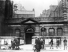
Aldgate East (London Underground)
Aldgate East is a London Underground station in the London Borough of Tower Hamlets . It is in the Travelcard tariff zone 1, at the intersection of Whitechapel High Street and Commercial Street. Trains of the District Line and the Hammersmith & City Line (formerly Metropolitan Line ) operate here . In 2014, 12.25 million passengers used the station.
history
The original Aldgate East station opened on October 6, 1884, as part of a joint route of the Metropolitan Railway (now the Metropolitan Line) and the Metropolitan District Railway (now the District Line) from the inner city ring to Whitechapel . The station building was then about a hundred meters to the west, in the immediate vicinity of Aldgate station . The connecting curve between Liverpool Street and Aldgate East was unusually tight, which over the years led to more and more capacity bottlenecks.
After more than 50 years, the Gleisdreieck at Aldgate was enlarged , which resulted in a much less tight curve. The old station was closed on October 30, 1938 and replaced by a new building at the current location; this also made it possible to use longer trains. St Mary's (Whitechapel Road) , the next station to the east, was now too close to Aldgate East and had to be closed. To compensate for this, an additional exit was created at the eastern end of the Aldgate East platform.
The new station is completely underground and also serves as a pedestrian underpass under the busy Whitechapel High Street. In order to create the necessary space for this, the tracks had to be lowered by more than two meters while the train was running. For this purpose, the ballast was first removed and the tracks laid on wooden struts. Then over 100 workers simultaneously lowered the tracks with the help of hooks. These hooks are still there today.
Web links
Individual evidence
- ↑ COUNTS - 2014 - annual entries & exits. (PDF, 44 kB) (No longer available online.) Transport for London, 2015, archived from the original on February 21, 2016 ; accessed on May 20, 2020 (English).
- ↑ a b District Line. Clive's Underground Line Guides, accessed January 21, 2013 .
| Previous station | Transport for London | Next station |
|---|---|---|
| Tower Hill |
|
St Mary's (Whitechapel Road) (closed) |
| Liverpool Street |
|
St Mary's (Whitechapel Road) (closed) |
Coordinates: 51 ° 30 ′ 54.5 " N , 0 ° 4 ′ 19.5" W.


