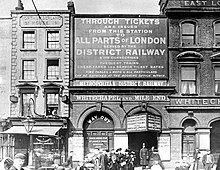
Whitechapel train station
The Whitechapel station is a common station of London Underground and London Overground in the urban district London Borough of Tower Hamlets . It is in the Travelcard tariff zone 2, at the intersection of Whitechapel Road and Brady Street. The District Line and Hammersmith & City Line operate on the upper station level in a west-east direction and the East London Line on the lower level in a north-south direction . In 2016, 14.37 million underground passengers used the station, plus 14.128 million rail passengers.
West of Whitechapel was a connecting curve (called St Mary's Curve ) between the District Line and the East London Line. This was used by passenger traffic until 1941, after which it was only used occasionally until 2008 to exchange trains between the lines. Also to the west of Whitechapel is St Mary's Station (Whitechapel Road) , which has been closed since 1938 .
history
Whitechapel station opened on April 10, 1876, when the East London Railway (ELR) opened the route between Wapping and Liverpool Street . The ELR owned the line and the stations, but did not operate the railway itself. From the beginning several companies used the route, including the London, Brighton and South Coast Railway (LB & SCR), the London, Chatham and Dover Railway (LC&DR) and the South Eastern Railway (SER); later the Great Eastern Railway (GER) was added.
On December 6, 1884, the District Railway (predecessor of the District Line) opened its own station above the existing ELR, as part of the line leading here from Mansion House . The station was named Whitechapel (Mile End) . In 1885 passenger traffic between Whitechapel and Liverpool Street was suspended, and on January 13, 1901, the station was given its current name. From February 1 to June 2, 1902, it was temporarily closed when the District Railway took the Whitechapel and Bow Railway to Bromley-by-Bow, built jointly with the London, Tilbury and Southend Railway (LT&SR), into operation. District trains now ran on LT & SR tracks to Upminster , and in summer to Southend-on-Sea .
In 1905 the District Railway was electrified. From 1906, the Metropolitan Railway extended the railway to Whitechapel, in 1936 to Barking. At times trains also went to Shoreditch. The metropolitan branch to Barking is now part of the Hammersmith & City Line. From December 2, 1906 to March 31, 1913, the trains on the East London Line only ran between Whitechapel and Shoreditch, the southern section only ran freight trains. After the closure of St Mary's Curve for passenger traffic on October 6, 1941, the East London Line was downgraded to a pure feeder line.
In the 1980s, London Regional Transport considered converting the low-traffic East London Line to a light rail system, similar to the Docklands Light Railway . Another plan was to reactivate the connecting curve at Shoreditch to Liverpool Street Station. From March 25, 1995 to March 25, 1998, the entire route was closed to all traffic due to modernization work in the Thames Tunnel . In preparation for the extension of the East London Line, the Whitechapel – Shoreditch section was closed on June 9, 2006. Before that, the trains only ran there during rush hour and on Sunday mornings. As of December 22, 2007, the East London Line station was closed again. The line was extended at both ends and reopened on April 27, 2010. Since then, the East London Line has been part of the London Overground route network.
future
As part of the Crossrail project, a train station for Crossrail, a S-Bahn-like connection through the city center, is being built under the underground station. When it opens in December 2019, it will be named Elizabeth Line. To the east of this, the tunnel will branch into two branches to Shenfield and Abbey Wood . The platforms of the Elizabeth Line are located north of the existing station, access is via escalators.
Web links
- Photo of the counter hall (1927)
- Photo of the East London Line platforms (1955)
- Photo of the platforms of the District Line (1957)
Individual evidence
- ↑ COUNTS - 2016 - annual entries & exits. (Excel) (No longer available online.) Transport for London , 2017, formerly in the original ; accessed on April 1, 2018 (English). ( Page no longer available , search in web archives ) Info: The link was automatically marked as defective. Please check the link according to the instructions and then remove this notice.
- ↑ Estimates of station usage, 2016/17 data. (Excel) Office of Rail and Road , 2017, accessed April 1, 2018 .
- ↑ Whitechapel station and St Mary's Curve track diagram. trainweb.org, June 29, 2004, accessed April 1, 2018 .
- ↑ a b c East London Line. Clive's Underground Line Guides, accessed April 1, 2018 .
- ↑ a b District Line. Clive's Underground Line Guides, accessed January 5, 2013 .
- ↑ Booming tube lines may be extended. The Times , April 10, 1987.
| Previous station | London Overground | Next train station | ||
|---|---|---|---|---|
| Shoreditch High Street | East London Line | Shadwell | ||
| Previous station | Crossrail | Next train station | ||
| Liverpool Street | Elizabeth Line (from 2018) |
Stratford | ||
| Canary Wharf | ||||
| Previous station | London Underground | Next station | ||
|
St Mary's (Whitechapel Road) (closed) |
District Line | Stepney Green | ||
| Hammersmith & City Line | ||||
Coordinates: 51 ° 31 '10.8 " N , 0 ° 3' 37.2" W.


