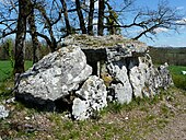
Allée couverte by Blanc
The Allée couverte of Blanc (also known as Dolmen de Blanc, Peyrelevade or Cros de la Viurge) is located south of the hamlet of Blanc, which belongs to Beaumont-du-Périgord, in the north of the municipality of Nojals-et-Clotte, near the D676 road in the extreme south of the Dordogne department in France .
The megalithic complex was mentioned by François Jouannet in the early 18th century, by W. Taillefer in 1821 and Leo Drounn in 1876 and is considered to be one of the best preserved in the Périgord region .
description
Although the complex is run as an Allée couverte , it is a "Dolmen Angoulême" (with a square or rectangular chamber). In France, dolmen is the generic term for Neolithic megalithic structures of all kinds (see: French nomenclature ). The original structure was supposedly about 12.0 meters long, the today about 2.0 m wide and 4.5 m long chamber is oriented northwest-southeast and is accessed by an approximately 1.2 m wide and 1.5 m long corridor. The chamber consists of two preserved, heavily weathered capstones that rest on three or four side plates.
The monument, owned by the Perigord Historical and Archaeological Society, has been the subject of an improper restoration that changed its original layout.
According to local tradition, the virgin built this dolmen for a young shepherdess who was frightened by a storm, hence the local name "Cros de la Viurge" (German cross of the virgin).
About 750 m northwest, on the road to Naussannes, is the dolmen of Peyre Nègre .
See also
literature
- Marc Devignes: Bilan du mégalithisme aquitain. In: La France des dolmens et des sépultures collectives (4500 - 2000 avant J.-C.). Éditions Errance, Paris 1998, ISBN 2-87772-157-4 , p. 27.
Web links
Coordinates: 44 ° 44 ′ 21 ″ N , 0 ° 45 ′ 12 ″ E

