
Huttrop old cemetery

The old Huttrop cemetery was created in 1878 as a municipal cemetery in what is now the Essen district of Huttrop . At that time Huttrop was part of the mayor's office in Stoppenberg , and in 1908 Huttrop was incorporated into the city of Essen. Dedicated in 1991, the burial site was turned into a park in which several tombs have been preserved, most of which are now listed .
history
prehistory
Before the burial site was built, the deceased of the still very rural Huttrop were buried in a cemetery in front of the Viehofer Tor of the Essen city wall , which had existed since 1863 . At that time Huttrop had a little over 500 inhabitants. Due to the onset of immigration of workers mainly for the booming coal mining industry, but also for the rapidly developing steel industry, the number was only 14 years later at 1200 inhabitants. In 1877, for example, the population and the mayor of the Stoppenberg mayor, Josef Hoeren, pushed ahead with the construction of a community cemetery in Huttrop. This was finally approved by the supervisory authority in Düsseldorf. Thereupon the community bought the originally square property as former arable land from the Huttrop farmer Bernhard Kaiser.
Distribution and location


The cemetery area was originally almost square and was divided into four equally sized squares by two main paths that crossed in the middle. An additional path ran around the area within 15 feet of the Rhine (around 4.7 meters) inside the cemetery boundary. The cemetery regulations passed by the local council on June 15, 1878 stipulated that the narrow strip between this path and the fence was reserved for hereditary burial sites, the four squares within the path for row graves, with the two northern quarters initially being used as garden land to a huttropic teacher were leased. The two southern grave fields were divided into a Protestant in the west and a Catholic in the east. In addition, a small morgue was built south of these two fields in 1881, which no longer exists. In 1895 the Catholic field was almost fully occupied, so that one year later the north-eastern quarter of the cemetery grounds was added.
In 1903 the last north-western quarter, previously leased as garden land, was released as a burial ground. However, row graves were not allocated there, as planned in 1878, but more family tombs were laid along the central main paths. The actual, northwestern cemetery district was used in 1907 to expand the schoolyard of the Catholic elementary school, which had been north of the cemetery on Steeler Chaussee since 1871. The building no longer exists. The angular floor plan of the cemetery that was created in this way has been preserved in today's park. It was divided in the middle by two paths, resulting in three squares. These paths are no longer available today. There is an entrance to each of the squares.
The main entrance to the cemetery was originally in the middle of its west side, where a dirt road ran north to Steeler Chaussee, today's Steeler Straße. This was given the name Friedhofstraße in 1897 and was renamed Seminarstraße in 1916. Today this street has a different course and flows into Moltkestrasse, the connection to Steeler Strasse no longer exists.
Funerals
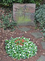
The first burials probably took place in row graves in 1879. Family graves, on the other hand, arose in the east from 1883, where the sandstone cemetery cross was erected on June 15, 1888. Due to damage, the remaining cross and the lower longitudinal beam are stored in the park cemetery . The completely preserved, 2.45 meter high pedestal bears the inscription: Blessed are the dead / those who die in the Lord / Rev. John 14.13. The pedestal and cross had a total height of 6.1 meters.
From the cemetery cross to the south and then to the west, these graves were laid out one after the other in the hereditary burial strip (excerpt): Community leader Wilhelm Hovescheidt, farmer Bernhard Kaiser (seller of the property for the community cemetery), Robert Kopp, Theodor Huttrop, widow Gertrud Stattrop, Heinrich Tönnishoff, Heinrich Feldhaus, widow Catharina Becks, Franz Brünglinghaus, Barkhoff, widow Elisabeth Schnutenhaus, Kreter, Spennemann and, as the youngest, Uhlendahl.
Competent churches
Services have been held since 1892 in the church of the Franz Sales House north of Steeler Chaussee, which was then consecrated as St. Maria Rosenkranz . Between 1928 and 1929 the first St. Boniface Church was built opposite the main entrance to the cemetery. It had to be abandoned and broken off in 1965 for capacity reasons. The successor building, the parish church of St. Bonifatius , in the form of a basilica by the architect Emil Steffann, has stood west of Moltkestrasse since 1961 .
closure
Until 1948, burials in row graves were possible. In 1989 the last burial took place in a hereditary burial place.
In 1991 the old cemetery in Huttrop was redesigned and converted into a public park. The rights to use the row graves had long since expired and had not been extended, so that the last graves were leveled as early as 1967. Rights of ownership and use of family or hereditary burial sites are always passed on to the next generation and were therefore only limited by the closure of the cemetery. That is why they have mostly been preserved to the last.
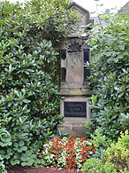
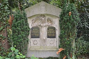
Tombs under monument protection
Several tombs of the family tombs along the old cemetery border were placed under monument protection in 2002. Including that of the Huttrop family, whose farm is the namesake of the farmers and later community. The preserved parts of the cemetery cross described above are also subject to monument protection.
The grave of the Brünglinghaus family has been a listed monument since 1998. The former huttrop farm Brünglinghaus in the area of today's intersection Ruhrallee / Schinkelstraße, of which no building parts exist anymore, existed before the 10th century.
- Tombs under monument protection

Wilhelm Hovescheidt family

Otto and Mathilde Kaiser

Theodor Huttrop family

Heinrich and Maria Feldhaus
Franz Brünglinghaus family
Theodor and Bernhardine Barkhoff

Godfr. and Martha Schnutenhaus

Conr. and Elishab. Cretans

Spennemann family

Heinrich and Anna Vohl
Gustav and Emilie Bubenzer
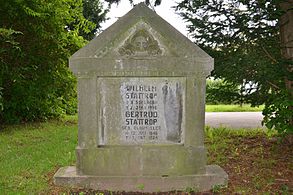
Wilhelm and Gertrud Stattrop

Pedestal of the cemetery cross


literature
- Franz Michels: On the history of the large farmers and the farm. In: Contributions to the history of the city and monastery of Essen , Volume 50. Essen 1932.
Web links
- Tombs and cemetery cross under monument protection - excerpt from the list of monuments of the city of Essen, No. 929 (PDF; 2.8 MB)
Coordinates: 51 ° 26 '47 " N , 7 ° 2' 42" E