Alvensleben tunnel
| Alvensleben tunnel | |||
|---|---|---|---|
| General information about the mine | |||
| Information about the mining company | |||
| Start of operation | 1825 | ||
| End of operation | 1864 | ||
| Funded raw materials | |||
| Degradation of | Iron ore | ||
| Geographical location | |||
| Coordinates | 50 ° 37 '0.4 " N , 7 ° 29' 50.8" E | ||
|
|||
| local community | Burglahr | ||
| District ( NUTS3 ) | Altenkirchen | ||
| country | State of Rhineland-Palatinate | ||
| Country | Germany | ||
| District | Bergrevier Hamm an der Sieg | ||
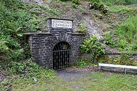
The Alvensleben tunnel with mouth hole near Burglahr was an inheritance tunnel of the Louise mine near Horhausen in the Altenkirchen district in the Westerwald .
In 1825, the tunnel was dug 40 m below the Louisen tunnel as an hereditary tunnel. With an advance of 14.6 cm per day and an average of 41 m per year, the tunnel was brought to a gradient of 1.5 mm / m (0.15%) and was built until 1864.
The length of the main tunnel is 1546 m. The following lengths were achieved:
|
|
|
In 1987, the tunnel was restored and prepared as a visitor tunnel over a length of 400 m .
The Alvensleben tunnel is a geopoint of the National GeoPark Westerwald-Lahn-Taunus .
literature
- Ute Bosbach: Searching for traces in Eisenland - On the way on ore roads and miners ' paths, amadeusmedien, November 2006. ISBN 3-9808936-8-5
Individual evidence
- ↑ G. Wolf: Description of the mountain district Hamm an der Sieg ; Bonn 1885
- ^ Journal for the mining, metallurgy and saltworks in the Prussian state , Berlin; Issues 1854–1868
Web links
Commons : Alvenslebenstollen - Collection of pictures, videos and audio files
- Description and contact for the visitor mine at Burglahr.de , accessed on November 24, 2014.
- Private website about the tunnel , accessed November 24, 2014.

