Amalia glacier
| Amalia glacier | ||
|---|---|---|
|
View of the glacier from Peel Fjord with Reclus volcano in the background |
||
| location | Magallanes y Antárctica Chilena , Chile | |
| Mountains | South Patagonian ice field , Andes | |
| Type | Valley glacier | |
| length | 21 km | |
| surface | 157 km² | |
| Exposure | west | |
| width | Max. 2.5 km | |
| Ice thickness | Max. 70 m | |
| Coordinates | 50 ° 55 ′ S , 73 ° 37 ′ W | |
|
|
||
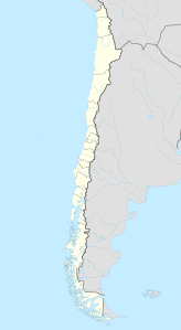
The Amalia Glacier (Spanish: Glaciar Amalia , also Glaciar Skua ) is a Chilean tidal glacier in the Bernardo O'Higgins National Park . It rises in the center of the southern Patagonian ice field, is 21 kilometers long and in 1986 covered an area of 157 km²; of which approx. 126 km² are in the accumulation area . The glacier flows into the Peel Fjord on the edge of the Sarmiento Canal , which was named after the navigator and scholar Pedro Sarmiento de Gamboa , who traveled through it in 1579/80.
The glacier partially surrounds the Reclus volcano, which last erupted in 1908 and has a crater diameter of one kilometer, from the north flank of which it removes material. In 1945 its extension was 190 km²; by 1986 there was a decrease of 17.5 percent. From 1945 to 1986 the Amalia Glacier retreated 7 kilometers; In addition to the retreat of the O'Higgins Glacier , this was the largest retreat of a glacier on this ice field.
Individual evidence
- ^ Geological Survey Professional Paper. Ed. US Government Printing Office, Volume 1386, pp. 1191.
Web links
- Glazeological information under serial no.24 ( Memento from December 16, 2012 in the Internet Archive )
- Tourist information about the glacier

