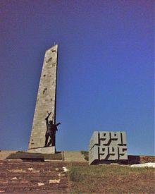
Sawur-Mohyla Hill
Coordinates: 47 ° 55 ′ 23 " N , 38 ° 44 ′ 26" E
The hill of Zawur-Mohyla ( Ukrainian Савур-могила ; Russian Саур-Могила / Saur-Mogila ) is a 277.9 m high strategic altitude in the Donets ridge 12 km south of the city of Snizhne and about 5 km away from the border between the Ukrainian Donetsk Oblast and Russian Rostov Oblast .
The hill is originally a burial mound ( Kurgahn ); "Mohyla" means "Tumulus" in Ukraine and according to one interpretation the word "Sawur" comes from the Turkish "Sauyr", which means "a steppe hill shaped like a horse back."
The height was the scene of skirmishes in the German-Soviet War and the War in Ukraine .
The monument on the hill was destroyed in the war in Ukraine . Alice Bota visited the hill in October 2014 together with photographer Sebastian Bolesch and reported in the weekly newspaper Die Zeit about the funeral of three pro-Russian separatists who died in the fight against the Ukrainian army on the hill.
Individual evidence
- ↑ Alice Bota: In the Republic of Lies, in: Die Zeit No. 43, October 16, 2014, p. 4.

