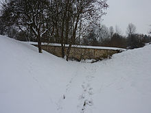
Obertal aqueduct
The aqueduct in Obertal is a remnant of a water supply system from the 18th century.
history
The Hohenkreuz Castle Estate may have existed in the Middle Ages ; However, its existence is only certain by a mention from the year 1551. It belonged to the citizen Clas Schweizer d. Ä., Later Johann Böhm or Behem, from 1596 the mayor David Buntz and from 1722 the later Barons von Palm . The manor house with the address Hohenkreuzweg 5, which is still preserved today, was probably built shortly after the von Palm family took over ownership; a dairy farm - Hohenkreuzweg 1 - was probably not added until 1775, but the water supply probably even earlier.
The facility was planned by Tobias Mayer the Elder. Ä. from Marbach am Neckar . Slope water was collected in a well in the Obertal district of Esslingen and then led to a well in the courtyard of the castle. The lines were initially made of wooden dicks , later of clay pipes. Two terrain cuts were bridged by aqueducts , one of which has been preserved. A plan of the well piping from the 18th century has also been preserved.
The aqueduct that has been preserved is a simple sandstone building that bridges a cut in the terrain called “Kalte Klinge” and can be seen from Kernenweg. It has two round arches. The former water pipe is covered. Because the water in the Obertal district was dug up through the construction of this water supply, the barons of Palm had the justice fountain, also known as the justice fountain, built on Kernenweg to compensate. The well system is located in a brick niche and consists of a simple well pipe and a rectangular trough made of cast iron , which was manufactured in 1868 by the G. Kuhn iron foundry . It has a classicist decor.
Web links
Individual evidence
- ↑ In the monument topography, the year of construction 1723 is given on both p. 303 and p. 341. However, this is the year of birth of the alleged planner Tobias Mayer the Elder. Ä. Here , however, it is reported that the aqueduct dates from the same time as the Fountain of Justice.
- ↑ Andrea Steudle et al.: Monument topography Federal Republic of Germany. Cultural monuments in Baden-Württemberg. Volume 1.2.1. City of Esslingen am Neckar. Ostfildern 2009, ISBN 978-3-7995-0834-6 , p. 303 with Fig. 825. The illustration shows the plan of the fountain pipe and indicates the time of origin "around 1732", which also suggests that the monument topography stated time of origin of the aqueduct is incorrect.
- ↑ Andrea Steudle et al.: Monument topography Federal Republic of Germany. Cultural monuments in Baden-Württemberg. Volume 1.2.1. City of Esslingen am Neckar. Ostfildern 2009, ISBN 978-3-7995-0834-6 , p. 341 with ill. 935 and 936.
Coordinates: 48 ° 45 ′ 38 " N , 9 ° 18 ′ 51.9" E

