Arizona State Route 287

|
|
|---|---|
| map | |

|
|
| Basic data | |
| Overall length: | 32.07 mi / 51.61 km |
| Starting point: |
|
| End point: |
|
| County: | Pinal County |
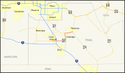
The Arizona State Route 287 (short- AZ 287 ) is a state highway in the US state of Arizona , the West-East direction is in.
The State Route begins at the intersection of Arizona State Route 84 and Arizona State Route 387 in Casa Grande and ends after 51.61 kilometers in Florence on Arizona State Route 79 .
course
After the intersection with State Routes 84 and 387 in the center of Casa Grande, AZ 287 leaves the town in an easterly direction. On the eastern outskirts State Route crosses the Interstate 10 approximately at the Exit 194. After 23 kilometers she meets in the area of La Palma northwest of Picacho reservoir on the Arizona State Route 87 , which together with the AZ 287 to the Casa Grande Ruins National Monument to the north of Coolidge use a joint route. State Route 287 leaves Coolidge heading east and ends after a total of 51.6 kilometers south of Florence on Arizona State Route 79.
See also
Web links
- Arizona Roads (English)