Arizona State Route 82

|
|
|---|---|
| map | |

|
|
| Basic data | |
| Overall length: | 66 mi / 106 km |
| Starting point: |
|
| End point: |
|
| Counties: |
Santa Cruz County Cochise County |
| Important cities: |
Sonoita Whetstone |
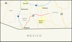
The Arizona State Route 82 (abbreviated AZ 82 ) is a state highway in the US state of Arizona that runs from west to east direction.
The State Route begins on Interstate 19 in the city of Nogales and ends north of Tombstone on Arizona State Route 80 . Halfway along the State Route it meets Arizona State Route 83 and after three quarters it crosses Arizona State Route 90 . The section between Patagonia and Nogales is also called Patagonia Road or Patagonia Highway .
See also
Web links
- Arizona Roads (English)
- AARoads (English)