Arnprior (Ontario)
| Arnprior | ||
|---|---|---|
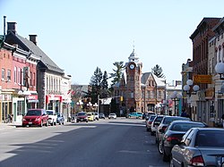
 John Street in Arnprior |
||
| Location in Ontario | ||
|
|
||
| State : |
|
|
| Province : | Ontario | |
| County : | Renfrew County | |
| Coordinates : | 45 ° 26 ′ N , 76 ° 21 ′ W | |
| Area : | 13.03 km² | |
| Residents : | 3114 (as of 2001) | |
| Population density : | 239 inhabitants / km² | |
| Time zone : | Eastern Time ( UTC − 5 ) | |
| Postal code : | K7S | |
| Mayor : | Terry Gibeau | |
Arnprior is a place in east Renfrew County in eastern Ontario in Canada . It is located at the mouth of the Madawaska River where it flows into the Ottawa River in the Ottawa Valley . The city had 7500 inhabitants in the 2001 census. Arnprior is located in Canada's economic region.
history
The area was first settled by Archibald McNab , who named the area after the homeland of his ancestors Arnprior in Scotland. After he was expropriated in 1840 by his despotic way of the people who lived on his land, the area was uncultivated until 1851. In 1851 it was finally connected to the timber production that arose in eastern Ontario. Arnprior was finally recognized as a village in 1862. Thirty years later (1892) Arnprior was recognized as a city.
Transport and traffic routes
Arnprior is on the Trans-Canada Highway system, where Highway 417 to the east becomes Highway 17 to the west. The city is served by the Arnprior / South Renfrew Municipal Airport and a nearby landing pad for seaplanes. Scheduled commercial flights are available from Ottawa Airport , 35 miles east of the city.
The city lies on the Ottawa River , but is separated from the lower Ottawa River and the St. Lawrence Seaway by waterfalls.
