
Madawaska River (Ottawa River)
| Madawaska River | ||
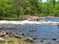
 Upper Madawaska River at Whitney |
||
| Data | ||
| location | Nipissing District , Renfrew County in Ontario, Canada | |
| River system | Saint Lawrence River | |
| Drain over | Ottawa River → Saint Lawrence River → Atlantic Ocean | |
| source | in Algonquin Provincial Park 45 ° 33 ′ 52 " N , 78 ° 37 ′ 56" W |
|
| Source height | 450 m | |
| muzzle | in the Ottawa River at Arnprior Coordinates: 45 ° 26 '34 " N , 76 ° 20' 55" W 45 ° 26 '34 " N , 76 ° 20' 55" W. |
|
| Mouth height | 70 m | |
| Height difference | 380 m | |
| Bottom slope | 1.7 ‰ | |
| length | 230 km | |
| Catchment area | 8470 km² | |
| Drain |
MQ |
85 m³ / s |
| Left tributaries | Opeongo River | |
| Right tributaries | York River | |
| Reservoirs flowed through | Lake Madawaska | |
The Madawaska River is a river in the Canadian province of Ontario .
The river has a length of 230 km and drains an area of 8470 km². It has its origins in Source Lake in the high elevations of Algonquin Provincial Park at an altitude of 450 m . From there it flows in an easterly direction and overcomes a difference in altitude of 380 m before it flows into the Ottawa River at Arnprior . In the late 19th century, the river was used to transport timber from the surrounding forest areas. In the early 1960s, the river was opened up for hydropower. Sections of the Madawaska River that are not dammed are used by canoeists , kayakers and amateur anglers.
Tributaries
Lakes and reservoirs
There are several larger lakes on the lower reaches of the Madawaska River, including:
fauna
The most common food fish that are caught in the Madawaska River are: Walleye ( yellow pickerel ), pike , muskellunge , smallmouth bass and largemouth bass .
Provincial Parks
Two sections of the river have the status of a provincial waterway park :
- Upper Madawaska River Provincial Park , between Whitney and Madawaska ; 10.85 km².
- Lower Madawaska River Provincial Park , between Latchford Bridge and Griffith ; 12 km².
Both parks are managed by Ontario Parks . However, they do not have a visitor infrastructure. Both parks are suitable for white water canoeing .
Hydropower plants
There are several hydropower plants along the Mawaska River operated by Ontario Power Generation (OPG).
In the downstream direction these are:
| Surname | completion position |
Power [MW] |
Number of turbines |
operator |
|---|---|---|---|---|
| Mountain Chute | 1967 | 170 | 2 | OPG |
| Barrett Chute | 1942-1968 | 176 | 4th | OPG |
| Calabogie | 1917 | 4th | 2 | OPG |
| Stewartville | 1948-1969 | 182 | 5 | OPG |
| Arnprior | 1976-1977 | 82 | 2 | OPG |
photos

White water canoeing and kayaking training at Palmer Rapids
Kayakers at Palmer Rapids

Ontario Highway 41 Bridge over the Madawaska River at Griffith

Mountain Chute Dam on the Madawaska River near Black Donald Lake


Web links
- Ontario Power Generation - History and water management ( Memento from January 5, 2014 in the Internet Archive )
- Ontario Parks - Upper Madawaska River
- Ontario Parks - Lower Madawaska River
Individual evidence
- ↑ a b c The Atlas of Canada - Rivers ( Memento from January 22, 2013 in the Internet Archive ) (English)
- ↑ OPG - Safety & Environment ( Memento from January 4, 2014 in the Internet Archive )
- ↑ OPG - Power Generation ( Memento from December 31, 2013 in the Internet Archive )