Arroyo Chuy
| Arroyo Chuy | ||
|
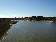
Mouth of the Arroyo Chuy into the Atlantic |
||
| Data | ||
| location | South America , Brazil , Uruguay | |
| River system | Arroyo Chuy | |
| source | at Santa Vitória do Palmar | |
| muzzle | southeast of Chuí in the Atlantic Coordinates: 33 ° 44 ′ 40 ″ S , 53 ° 22 ′ 10 ″ W 33 ° 44 ′ 40 ″ S , 53 ° 22 ′ 10 ″ W
|
|
| length | 45 km | |
|
Lighthouse, in Portuguese Farol da Barra do Chuí , on the Brazilian bank of the Arroyo Chuy |
||
The Arroyo Chuy ( Portuguese Arroio Chuí ) is a small river in South America.
Its source is on Brazilian territory in the state of Rio Grande do Sul near Santa Vitória do Palmar . From there it flows in a north-south direction to the twin towns of Chuí / Chuy , on the eastern edge of which it flows, and then forms the natural border between the two countries Brazil and Uruguay on its last section , before finally flowing north of Barra del Chuy into the Atlantic flows out. The southernmost point of Brazil is located at its lower reaches.
The total length of the Arroyo Chuy is about 45 km. Its name comes from the Tupí-Guaraní language and translated into German means bird .


