Ashitaka (volcano)
| Ashitaka | ||
|---|---|---|
|
Ashitaka as seen from the southeast |
||
| height | 1504.2 m | |
| location | Shizuoka , Japan | |
| Coordinates | 35 ° 13 '48 " N , 138 ° 47' 24" E | |
|
|
||
| rock | Basalt, dacite | |
|
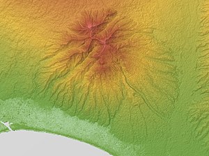
Relief map |
||
The Ashitaka ( Japanese 愛鷹山 Ashitaka-yama , historically also: 足高山 ) in Kunrei transcription Asitaka , is a stratovolcano in eastern Japanese prefecture of Shizuoka . It forms the border of the municipalities of Fuji , Numazu , Nagaizumi and Susono .
The highest peak is the Echizen-dake ( 越 前 岳 ) with 1504.2 m , while the eponymous central peak Ashitake-yama, 4.5 km southeast of it, only has a height of 1187.5 m .
The last eruptions took place around 100,000 to 400,000 years ago. It is located within a subduction zone . The volcano has several peaks.
Individual evidence
- ^ Official topographic map of Kokudo Chiriin
- ↑ Global Volcanism Program | Ashitaka. Retrieved July 22, 2019 .
- ^ S. Nakano, T. Yamamoto, T. Iwaya, J. Itoh, A. Takada: Quaternary Volcanoes of Japan . In: AIST (Ed.): Geol Surv Japan . 2001.
- ↑ volcano. Retrieved July 22, 2019 .
- ↑ Landforms, Geology, and Tectonics . In: Japan Association Quaternary Research (Ed.): Quaternary Maps of Japan . Univ Tokyo Press, Tokyo 1987, OCLC 18171609 .


