Assateague Island

Assateague Island is an uninhabited American island in Maryland and Virginia . The elongated dune island on the east coast of the United States of America is 60 km long in north-south direction. The United Nations has declared Assateague Island a Biosphere Reserve . The United States Department of the Interior has declared the entire island a National Natural Landmark .
The island has marshland , bays, sandy beaches and sandy coves.
There are three conservation agencies on the island that are responsible:
- Maryland (both IUCN Category V)
- Assateague Island National Seashore
- Assateague State Park (3.2 km²)
- Virginia
- Chincoteague National Wildlife Refuge , 57 km² (IUCN Category IV).
Wild Assateague ponies ( Chincoteague ) exist on the island .
The border between the states on the island is marked by a high fence. The Chincoteague Volunteer Fire Department in Chincoteague, Virginia owns the largest herd of Chincoteague ponies on the island.
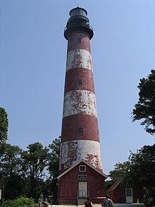
On the Virginia Eastern Shore is the Assateague Lighthouse from the 1830s with a height of 43 m at the south end of Assateague Island. It is listed on the National Register of Historic Places .
See also
Web links
Individual evidence
- ^ Kenney, Nathaniel T., "Watermen's Island Home," National Geographic Magazine , Index (January – June 1980), vol. 157 (June 1980): 812.
- ↑ GMCO Maps & Charts. GMCO's Fishing & Recreation Map of Chincoteague-Assateague, Virginia , 2003.
- ^ Assateague Island National Seashore page on wild horses National Park Service .
Coordinates: 38 ° 5 ′ N , 75 ° 13 ′ W
