
Ouch (island)
| Ouch | ||
|---|---|---|
.JPG) |
||
| Waters | Pacific Ocean | |
| Archipelago |
Bismarck Archipelago ( Western Islands ) |
|
| Geographical location | 1 ° 27 ′ 0 ″ S , 143 ° 4 ′ 0 ″ E | |
|
||
| length | 3.9 km | |
| width | 2.5 km | |
| surface | 7 km² | |
| Residents | 419 (2000) 60 inhabitants / km² |
|
| main place | Pirgur | |
 |
||

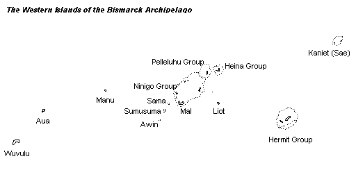
Aua is an island in the western area of the Bismarck Archipelago . Administratively, the island belongs to the Manus Province in Papua New Guinea .
geography
The island is about 900 km northeast of Papua New Guinea's capital Port Moresby and 255 km northwest of the provincial capital Manus . The island, which is only a few meters above the sea, is approximately 7 km². At the 2000 census, Aua had 419 inhabitants.
On Aua there is an airfield with the IATA airport code AUI.
The island is traditionally divided into three districts, which were headed by chiefs ( puala ) until 1904 . At the time, the population of Aua was estimated at 2000. The villages and hamlets, presided over by lower-ranking chiefs ( päavi ), are or were all on the coast:
These settlement names no longer appear in the current census geography.
| Oala district in the northwest villages from north to south: |
Laroaro district in the southwestern villages from west to east: |
Bāarafu district in the east 14 submerged villages |
|---|---|---|
|
|
Bāarafu was once the most populous district, but is now uninhabited. Today Laroaro is the most populous district. The puala of Laroaro resided in the village of Pirgur.
Individual evidence
- ↑ George Lane Fox Pitt-Rivers: Aua Island: Ethnographical and Sociological Features of a South Sea Pagan Society. The Journal of the Royal Anthropological Institute of Great Britain and Ireland, Vol. 55, (Jul. - Dec., 1925), pp. 425-438
Web links
- Map with the neighboring islands
- Description of the island in the German Colonial Lexicon , editor Heinrich Schnee , 1920