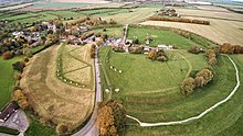
Avebury
The stone circle / henge of Avebury is in the village of Avebury in the county of Wiltshire east of Bath . He is one of the largest stone circles in the British Isles and belongs since 1986 as part of the Stonehenge, Avebury and Associated Sites to World Heritage of UNESCO .
The sandstones come from about two kilometers away. The stone circle of Avebury, including the surrounding wall, covers an area of about 15 hectares, is now partially built-up and consists of the large outer circle and two smaller inner circles. The center line is the midsummer - Sunrise aligned.
history
The henge was built from 2600 to about 2500 BC. Built in BC. Like Marden , Durrington Walls and Mount Pleasant (Dorchester) it belongs to the great Neolithic henges and can be associated with the Grooved ware .
From the 14th century, the destruction of the monument began on the instructions of the Christian Church. Many stones were then buried. According to a village legend, a bather is said to have been killed by a falling stone during such a "stone burial" and buried under it. In 1938 a skeleton was actually discovered by the archaeologist Alexander Keiller , along with coins, a burin and a very well-preserved pair of scissors, which were a rarity at the time. Based on the minting of the coins, the year of his death could be narrowed down to 1320 at the earliest. Today the stone is also called “Barber Stone” and is a flat, narrow stone. However, a re-examination of the skeleton in 1999 showed that it had no injuries to confirm that the man had actually been slain by the 13-ton stone. It is therefore assumed that the man had already died and was buried under the stone with his property by the villagers for reasons as yet unknown.
In order to gain space for agriculture, more stones were removed in the 17th and 18th centuries and used, for example, to build houses. In order to destroy the very hard stones, they were heated with fire and then cold water was poured over them. The stones could be split and dismantled with tools along the cracks caused by thermal stresses .
In 1648 the scholar John Aubrey recognized the soil features and the large stones in the landscape and in the village as a prehistoric stone circle, which he attributed to druids who lived about 2000 years after the stone circles were built. The scholar William Stukeley called the stone circle from 1720 as a shrine of the British Druids (Temple of British Druids).
Excavations
Excavations were carried out by Alexander Keiller in the 1920s. In 1930 numerous stones were erected by the National Trust .
construction
The geometry of the Avebury Stone Circle is far more advanced than that of any of the UK's other stone circles.
Of the original 154 megaliths (stones), 36 are still preserved today. Together with the stone avenues, the complex consisted of around 600 megaliths. The locations of the destroyed stones in the stone circles are marked with concrete pillars. The destroyed avenues were only partially completed.
Outer large stone circle (around 2500 BC)
- Circumference approx. 1200 m
- Diameter 427 m
- Originally 98 stones were placed on a 6 m high earth wall, 27 of which have been preserved. The stones were 2.1 m to 5.5 m high and weighed up to 40 tons.
They are anchored 15 to 60 cm deep in the ground. The largest stone ("Obelisk") was 5.5 m high and was overturned and destroyed in the 18th century.
Inner small northern circle (around 2600 BC)
- approx. 98 m diameter
- of the original 27 stones, four have been preserved.
Inner small southern circle (around 2600 BC)
- approx. 104 m diameter
- five of the original 29 stones have been preserved.
Information for visitors
The entire area is freely accessible. Also worth seeing are the Alexander Keiller Museum in the historic barn and the medieval village church, which also houses the tourist information. If you follow the narrow road along Steinallee southwards, you will reach a larger country road after a short drive. If you turn right there, West Kennet Long Barrow , Silbury Hill and Swallowhead Springs , the source of the Kennet , can be visited.
literature
- Avebury Archaeological & Historical Research Group (AAHRG), Archaeological research agenda for the Avebury World Heritage Site (Salisbury 2001).
- Graham Brown / David Field / David Omish (eds.): The Avebury landscape: aspects of the field archeology of the Marlborough Downs (Oxford, Oxbow 2005).
- Aubrey Burl: Prehistoric Avebury (London, Yale University Press 2002), revised new edition. older state of research
- Michael Dames: The Avebury cycle (Thames and Hudson Ltd., London, 1996), the book originally dates from 1977. The second edition published in 1996 has been revised. ( ISBN 0500278865 )
- Mark Gillings / Joshua Pollard: Avebury (London, Duckworth 2004).
- Joshua Pollard / Andrew Reynolds, Avebury: the biography of a landscape (Stroud, Tempus, 2002).
- Ester Smith, Avebury Avenues - the way to discover the stone circles, second edition 2005 , Forward Publications, ISBN 0-9544916-0-2
Web links
Individual evidence
- ^ Associated metal objects
- ↑ Ronald P. Vaughan: Genius and Geometry - Stonehenge and Measuring the World. 3sat, 2010, accessed January 29, 2013 .
Coordinates: 51 ° 25 ′ 42 " N , 1 ° 51 ′ 14" W.


