
West Kennet Long Barrow


The West Kennet Long Barrow is about 5,500 years old Neolithic grave hill from the Cotswold-Severn type in the town of West Kennet in Wiltshire in England . It is one of the largest and best preserved megalithic systems of its kind.
Ownership and whereabouts
The long bed is available as " scheduled monument " since the 1880s under Pitt-Rivers under state protection and heard as part of the Stonehenge, Avebury and Associated Sites to World Heritage of UNESCO . West Kennet Long Barrow is owned by English Heritage and administered by the National Trust . The finds are in the Alexander Keiller Museum , High Street, Avebury , Marlborough , Wiltshire .
construction
The trapezoidal hill is made of chalk and is about 100 m long. The building material was extracted from shallow trenches along the long sides of the hill. A wide berm separates the ditches from the hill. The trenches are now backfilled with earth. A geophysical survey in 1992 showed that the hill was built in at least two phases, which explains its irregular course. The chamber at the head end in the east was built from quartzite boulders ( sarsen ). The axial passage tomb has five chambers. The forecourt is semicircular.
Burials
The remains of at least 46 people were found, men, women and about a dozen children. Only a few skeletons were complete; some were missing skulls. It looks as if the bones have been rearranged and removed from the grave for rituals. Cremation burials are also documented. The period in which this site was used (even after the burials ended) is around 650 years. Early Neolithic ceramics ( Windmill Hill Ware , today mostly called "Western carinated"), Peterborough ware and bell beakers were found. In the time of the bell jar, the grave was filled with earth and the entrance was closed with a row of stones. Examination of the human remains revealed that the burials often suffered from arthritis and dental problems.
Excavation history
The first excavations were found in 1678–1685 by a Dr. Toope from Marlborough instead. Among other things, it disrupted the southern ditch. John Aubrey mentioned the grave, William Stukeley made the first plans in 1723/24. In 1859 the burial mound was excavated by John Thurnam , he exposed parts of the western burial chamber and the passage. The other chambers were uncovered in 1955 by Stuart Piggot and Richard Atkinson . The entrance was restored after these excavations.
Nearby sites: Silbury Hill , Avebury Stone Circle , Windmill Hill , Overton Down , Overton Hill
gallery
- West Kennet Long Barrow

blackboard

North elevation
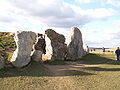
Front
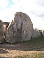
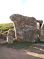
Front stone in front of the entrance (over 2 m high)
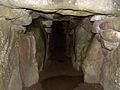
Central aisle

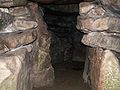
one of the north chambers

one of the southern chambers
Ostkammer (subsequent extension)

Access detail
"Smaller" stone in the row of stones in front of the entrance

Access with front stone

View from West Kennet Long Barrow on Silbury Hill
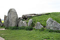
Exterior view

inside view

Access


Web links
- http://www.eng-h.gov.uk/reports/west_kennet/ Geophysical Survey, English
- http://pastscape.english-heritage.org.uk/events.aspx?a=0&hob_id=220853
literature
- David Field, Earthen long barrows: the earliest monuments in the British Isles. Stroud, Tempus, 2006.
- Stuart Piggott : The Excavation of the West Kennet Long Barrow: 1955-6. Antiquity 32, 1958, 235 ff.
- Stuart Piggott, The West Kennet Long Barrow: Excavations 1955-6. (London, HMSO 1962).
- Julian Thomas , Alistair Whittle 1986. Anatomy of a tomb: West Kennet revisited. Oxford Journal of Archeology 5, 1986, 129-156.
- John Thurnam, Archaeologia: or miscellaneous tracts relating to antiquity. Society of Antiquaries of London 38, 1861/2: 405-421.
Individual evidence
- ↑ http://pastscape.english-heritage.org.uk/hob.aspx?a=0&hob_id=220853 ( page no longer available , search in web archives ) Info: The link was automatically marked as defective. Please check the link according to the instructions and then remove this notice.
- ↑ http://pastscape.english-heritage.org.uk/events.aspx?a=0&hob_id=220853 ( page no longer available , search in web archives ) Info: The link was automatically marked as defective. Please check the link according to the instructions and then remove this notice.
Coordinates: 51 ° 24 ′ 31 ″ N , 1 ° 51 ′ 3 ″ W.