Börwang
|
Börwang
Coordinates: 47 ° 46 ′ 52 ″ N , 10 ° 21 ′ 39 ″ E
|
|
|---|---|
| Height : | 727–804 m above sea level NN |
| Residents : | 1661 (2015) |
| Postal code : | 87490 |
| Area code : | 08304 |
|
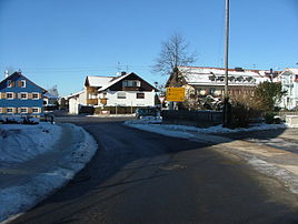
Main street in Börwang
|
|
Börwang is a district of the municipality Haldenwang in the Bavarian district of Oberallgäu .
geography
Börwang is located on the northern edge of the Oberallgäu district , south of Haldenwang on state road 2055 between Leubas and Waizenried . The A7 runs a few kilometers to the west and the Kronholz forest area to the east.
Attractions
- Leonhard Chapel (built between 1450 and 1480)
- Wagegg Castle (first mentioned in 1170)
Culture
- Leonhardiritt (around November 6th)
The first Leonhardiritt in Börwang took place in 1921. In the village square the participating horses and the livestock present as well as all parked cars are blessed.
- Klaus driving on December 5th
There is a long tradition of driving in Klausen in Börwang, but the Börwangs Klausen eV association was not founded until 2006 . The association has made it its goal to maintain the customs and thus keep them alive in the long term.
Web links
Commons : Börwang - collection of images, videos and audio files


