
Haldenwang (Oberallgäu district)
| coat of arms | Germany map | |
|---|---|---|
.svg)
|
Coordinates: 47 ° 48 ' N , 10 ° 21' E |
|
| Basic data | ||
| State : | Bavaria | |
| Administrative region : | Swabia | |
| County : | Oberallgäu | |
| Height : | 757 m above sea level NHN | |
| Area : | 26.69 km 2 | |
| Residents: | 3814 (Dec. 31, 2019) | |
| Population density : | 143 inhabitants per km 2 | |
| Postal code : | 87490 | |
| Area code : | 08374 | |
| License plate : | OA | |
| Community key : | 09 7 80 122 | |
| Community structure: | 36 parts of the community | |
| Address of the municipal administration: |
Römerstrasse 3 87490 Haldenwang |
|
| Website : | ||
| Mayor : | Josef Wölfle (CSU / Free Voters) | |
| Location of the municipality of Haldenwang in the Oberallgäu district | ||
  |
||


Haldenwang is a municipality in the Swabian district of Oberallgäu .
geography
location
Haldenwang is located in the Allgäu region on the eastern edge of the Iller valley. The parish church is 752 meters above sea level. A ridge in the east rises 150 meters higher. The Iller and the Iller Glacier shaped the landscape in the course of the earth's history.
Expansion of the municipal area
The municipality consists only of the Haldenwang district . There are 36 officially named parts of the municipality (the type of settlement is given in brackets ):
|
|
|
history
Until the church is planted
The name is derived from the Old High German words halda (slope) and wang (area). The Illertal was already densely populated in Roman times. At that time there were probably settlements on the eastern edge of the valley, and it was not far to the city of Cambodunum . In the early Middle Ages , feudal men from the Ottobeuren monastery sat at Wagegg Castle ; in later times they were ministerials from the Kempten monastery . A knight Walther von Wagegg is recorded in 1180, a knight from Schellenberg and Wagegg in 1374 and a knight Caspar von Laubenberg and Wagegg in 1468. Before 1800 Haldenwang was the seat of an upper and lower court of the same name and belonged to the Baron von Freyberg-Eisenberg. With the Rheinbund act 1806 the place came to Bavaria. In 1818 the community was founded.
Until the regional reform , Haldenwang belonged to the Kempten district . This was dissolved on July 1, 1972.
Population development
- 1961: 1746 inhabitants
- 1970: 2086 inhabitants
- 1987: 2726 inhabitants
- 1991: 2845 inhabitants
- 1995: 3107 inhabitants
- 2000: 3474 inhabitants
- 2005: 3698 inhabitants
- 2010: 3684 inhabitants
- 2015: 3755 inhabitants
Between 1988 and 2018 the municipality grew from 2731 to 2780 by 1049 inhabitants or by 38.4%.
politics
mayor
Mayor has been Josef Wölfle (CSU) since May 1, 2014; he was elected on March 15, 2020 with 86.04% of the vote for a further six years.
Municipal council
The election on March 15, 2020 had the following result:
- Free voters : 7 seats (40.29%)
- CSU : 6 seats (39.68%)
- Alliance 90 / The Greens : 3 seats (20.03%).
The turnout was 63.95%.
coat of arms
|
|
Blazon : “Split; in front a golden rosette in black, behind sheathed in silver and red. " |
Attractions
- Parish Church of St. Theodor and Alexander
- Leonhardi Chapel in Börwang
- Leonhardiritt at the patronage (November 6th)
- Wagegg castle ruins
- War memorial

Börwang with the Allgäu Alps

Fleschützen

Haldenwang in the Allgäu

War memorial on the main street
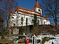
Parish church


.jpg)
Economy and Infrastructure
Economy including agriculture and forestry
In 1998 there were nine employees in the field of agriculture and forestry, 666 in the manufacturing sector and 58 in the field of trade and transport. In other economic sectors, 122 people were employed at the place of work subject to social security contributions. There were a total of 1182 employees at the place of residence subject to social security contributions. There were eight companies in the manufacturing sector and nine in the construction sector. In addition, in 1999 there were 67 farms with an agriculturally used area of 1695 ha. By far the most important employer in northern Oberallgäu is MAHA Maschinenbau Haldenwang , which produces systems for testing and safety technology for motor vehicles.
education
The following institutions exist (as of: 1999):
- Kindergartens: 125 kindergarten places with 113 children
- Elementary schools: one with twelve teachers and 213 students
Personalities
- Johann Georg Hiltensperger (1806–1890), history painter and professor at the Academy of Fine Arts in Munich
Web links
Individual evidence
- ↑ "Data 2" sheet, Statistical Report A1200C 202041 Population of the municipalities, districts and administrative districts 1st quarter 2020 (population based on the 2011 census) ( help ).
- ↑ Mayor. Haldenwang municipality (Oberallgäu district), accessed on August 12, 2020 .
- ↑ Haldenwang municipality in the local database of the Bavarian State Library Online . Bavarian State Library, accessed on August 15, 2019.
- ↑ Entry on the coat of arms of Haldenwang (Oberallgäu district) in the database of the House of Bavarian History

Altusried | Bad Hindelang | Balderschwang | Betzigau | Blaichach | Bolsterlang | Buchenberg | Burgberg im Allgäu | Dietmannsried | Durach | Fishing in the Allgäu | Haldenwang | Immenstadt im Allgäu | Arbors | Missen-Wilhams | Obermaiselstein | Oberstaufen | Oberstdorf | Ofterschwang | Oy-Mittelberg | Rettenberg | Sonthofen | Sulzberg | Waltenhofen | Weitnau | Wertach | Wiggensbach | Wildpoldsried
Unregulated areas:
Kempter Wald