
Búrfell (Þjórsá)
| Búrfell (Þjórsá) | ||
|---|---|---|
 Búrfell on the Þjórsá |
||
| height | 669 m | |
| location | Iceland | |
| Coordinates | 64 ° 5 ′ 13 ″ N , 19 ° 49 ′ 40 ″ W | |
|
||
| Type | Tabular volcano | |

The mountain Búrfell is a 669 m high table volcano in the south of the Icelandic highlands .
Surname
The name of the mountain, Búrfell, means pantry mountain in German . There are numerous mountains with this name in Iceland, so they are differentiated by nicknames.
Volcanism
The tabular volcano is in the area of influence of the Hekla .
It was formed during the Ice Age , which lasted in Iceland until about 10,000 years ago.
The floor of the valley of the rsjórsá , from which the mountain protrudes, is covered by approximately 3,500 year old lavas, the so-called Búrfellshraun . The lavas come from craters in the Tungnaá area, which are part of the Bárðarbunga volcanic system .
Búrfellsvirkjun power station
At its feet on the river Þjórsá is currently the second largest hydroelectric power station in the country, the Búrfellsvirkjun . It was opened in 1969 to power an aluminum plant near Reykjavík and has a capacity of 270 MW. Parts of the river water are channeled through the mountain in tunnels to increase the gradient and to drive the turbines on the other side.
On the other hand, water is naturally withdrawn from the river and waterfalls like the Tröllkonuhlaup and the Þjófafoss are no longer as impressive in summer.
See also
Web links
Individual evidence
- ↑ cf. disambiguation Búrfell
- ↑ Thor Thordarson, Armann Hoskuldsson: Classic Geology in Europe 3. Iceland. Harpenden 2002, p. 85
Picture gallery
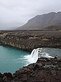
Þjófafoss waterfall near Búrfell

Búrfell with the river Þjórsá
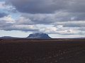
Búrfell

Búrfellsvirkjun power station


