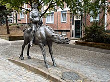
Badstüberstrasse (Rostock)

The Rostock Badstüberstraße is a historic street in the city center of the Hanseatic city . In a north-south direction, it connects Strandstrasse in the north with Lange Strasse in the south. The Badstüberstrasse, now largely a pedestrian zone , was a street in the former Rostock Neustadt .
Today's course
Coming from Langen Strasse in the south, Badstüberstrasse first crosses with the street An der Oberkante , which connects it with Grapengießerstrasse in the west and its eastern parallel streets . At the top is an artificially created street parallel to Lange Straße. Then the Badstüberstrasse continues as a pedestrian zone, only interrupted by the Aalstecherstrasse , which joins to the west, and the Auf der Huder street, which leads east . At its northern end it meets the beach road. Besides the castle ramparts, it is the only way for drivers to leave Lange Straße in a northerly direction.
history
In the original grid-like street arrangement of the former Rostock Neustadt and the northern Mittelstadt , it was one of nine streets that connected the city harbor on the beach, i.e. the Unterwarnow , with the Lange Straße and the Neuer Markt . These streets, which were located between the western city wall and the pit, today's Grubenstrasse in the east, were of great importance for a merchant town like Rostock. Compared to its eastern parallel streets, Badstüberstrasse was, however, of much less importance, which is evidenced by the fact that it was named not after merchant families, but after a profession.
First mentioned in 1271 as badstövere strate , it got its name from the Badstövern - "Badstübern" - who were administrators of public bathing rooms . There were several of these institutions in Badstüberstrasse, but also in other parts of the city. Public bathing rooms were very popular in the Middle Ages, so there are streets with the same name in five other cities in Mecklenburg-Western Pomerania , for example in Stralsund , Anklam or Grimmen .
On the beach, Badstüber Straße was bordered by the Badstüber Tor , through which you came to a merchant's bridge called Badstüberbrücke . These bridges were wooden jetties that enabled ships to dock.
From the Middle Ages to the 19th century, Badstüberstraße was the domicile of boatmen and boatmen who lived mainly in small booths. The south side of the street also served as the backyard of the streets on Langen Straße. Because of these two factors, the development on Badstüberstrasse was not particularly representative.
In the nights of bombing at the end of April 1942 , Badstüberstrasse suffered only relatively little damage, apart from the Mecklenburg Higher Regional Court on the corner of Langen Strasse, but the old building fabric will be in the coming decades, as in the entire northern old town , (the area between Langer Strasse and the city harbor, not to be confused with the historic Rostock old town) has been very badly neglected. From 1978 onwards, a so-called area renovation , i.e. a total demolition, was carried out in Badstüberstrasse . Then the area is rebuilt with houses in modified panel construction . These houses should be reminiscent of Hanseatic gabled houses in size and shape. The historic street lines were essentially retained, but the course of the historic and today's Badstüberstrasse are not identical.
The only historical building is located at Badstüberstrasse 6. It is an exceptionally large warehouse from around 1800 that has been converted for residential purposes.
Today Badstüberstrasse and its surroundings are a quiet and attractive residential area.
literature
- Ernst Münch , Ralf Mulsow; Old Rostock and its streets. Redieck & Schade, Rostock 2006, ISBN 3-934116-57-4 .
Web links
Coordinates: 54 ° 5 '26.7 " N , 12 ° 7' 58.6" E