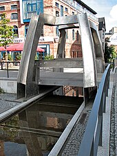
Pit road
The Grubenstrasse in Rostock is a north-south street in the historic center of the Hanseatic city . It represents the border between the former suburbs of the old town and the middle town and has a length of about 550 meters. The Grubenstraße has local significance for traffic as part of a connection between the Steintor suburb and the Am Strande road and Rostock city harbor .
The Warnow tributary "Grube" ran from Mühlendamm to Unterwarnow in its place until the middle of the 19th century .
course
It branches off in the north at the city harbor from the street Am Strande and ends in the south at the square at the Viergelindenbrücke . From the west, the Strandstrasse , the Kleine Mönchenstrasse , the Krämerstrasse, the Fischbank (central part of the city) and the Weißgerberstrasse all flow into it . From here, the street Beim Katharinenstift , the Hartestrasse , the Fischbank (old town part), the Molkenstrasse , the Wollenweberstrasse and the Mühlenstrasse branch off in an easterly direction .
Since the new market was closed in 2003, Grubenstrasse has been the only way to cross the north-south route within the old town for motorists.
Between the lanes of the Grubenstrasse there is a small watercourse on marble-colored slabs, which is supposed to symbolize the original pit .
history
The name of the Grubenstrasse is derived from a former branch of the Warnow , which connected the Oberwarnow on Mühlendamm with the Unterwarnow. This "pit" thus represented a natural border between the old town in the east with the Petri and Nikolaikirche and the middle town with the Marienkirche . Since the Oberwarnow was to the east of the old town and the Unterwarnow to the north, the old town was an "island". Supplemented by the Neustadt in the west with the Jakobikirche , these sub-towns merged in 1265 to form the entire city of Rostock. According to the latest findings, in the founding phase of the city of Rostock (early 13th century), merchant ships went up the pit to be unloaded on its bank. Thus the pit would be Rostock's oldest port, older than today's city port.
In order to be able to cross the pit, bridges were built on all the roads leading to it, which bore the name of these streets, so there was a Krämerbrücke and a Mönchenbrücke . The former Viergelindenbrücke in the south proves that the watercourse of the pit also serves as a location for water mills (Grinds were grinding tunnels). At the mouth of the pit stood the pit gate , also known as the Herring or Lazarettor, one of 12 beach gates that used to be.
In 1852 the pit was vaulted and filled in, but this area was below the level of the rest of the area, so that it still had to be crossed with bridges. In 1850 Rostock was connected to the railway network in the German Confederation , south of the pit, in front of the city walls, the Friedrich-Franz-Bahnhof was built , named after Grand Duke Friedrich Franz II of Mecklenburg-Schwerin . By laying tracks in the pit, which was now called Grubenstrasse , in 1852, the Friedrich-Franz-Bahnhof was connected with the city harbor. Together with another route to the southwest and west of the ramparts , this route was the backbone of the port railway . In the course of the four-night bombardment of the British Air Force from April 24 to 29, 1942, most of the Grubenstrasse, which mainly consisted of stores from the 18th and 19th centuries, was destroyed. The only preserved historical building is a narrow granary north of the corner of Harte Strasse, which dates from the late 18th century.
In the 1950s, Grubenstrasse was rebuilt in the northern area with simple functional buildings, but the southern area was heavily neglected in later times. In the course of the construction of the overseas port, the city port and thus the port railway lost their importance. With the turnaround and the cessation of port operations, the tracks were removed. In the mid-1990s, the Grubenstrasse was reconstructed and redesigned, so the watercourse in the middle of the street and the space bracket , a symbolic replica of the Viergelindenbrücke, are reminiscent of the former “pit”.
Individual evidence
Web links
Coordinates: 54 ° 5 ′ 24 ″ N , 12 ° 8 ′ 35 ″ E

