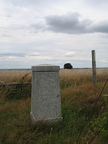
Baeyerhöhe
| Baeyerhöhe | ||
|---|---|---|
|
View of the Baeyerhöhe |
||
| height | 320.5 m above sea level HN | |
| location | Saxony , Germany | |
| Coordinates | 51 ° 4 '28 " N , 13 ° 27' 58" E | |
|
|
||
The Baeyerhöhe is a 320.5 m high mountain in the Meißner highlands . It is the highest point in the district of Meissen in Saxony .
Geographical location
The Baeyerhöhe lies between Kleiner Triebisch and Triebisch in the municipality of Klipphausen , west of the Lampersdorf district . Autobahn 4 runs in the south .
Between Taubenheim and Burkhardswalde , the Baltic Sea-Saale dams long-distance hiking trail leads over the mountain.
history
As station no. 12 Baeyerhöhe , the mountain was a first-order station of the Royal Saxon Triangulation in the 1860s . For this reason, a surveying column was erected on the summit. The survey is named after Johann Jacob Baeyer , the founder of the European degree measurement .
Web links
Commons : Baeyerhöhe - collection of images, videos and audio files


