
Ib
| Ib | |||
|---|---|---|---|
|
|||
| Data | |||
| Operating point type | Intermediate station | ||
| Platform tracks | 2 | ||
| abbreviation | IB | ||
| location | |||
| State | Odisha | ||
| Country | India | ||
| Coordinates | 21 ° 49 '1 " N , 83 ° 56' 56" E | ||
| Height ( SO ) | 207 m | ||

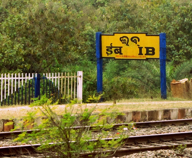
The Ib Station ( Oriya ଈବ ରେଳ ଷ୍ଟେସନ ) is on the river Ib at the stretch Tatanagar - Bilaspur route Howrah - Nagpur - Mumbai in India . It is characterized by the fact that it bears the shortest station name of all Indian stations with just two letters next to Od station.
Surname
The station takes its name from the nearby Ib river .
location
Ib Station is located in the Odisha region at an altitude of 207 m (679 ft) above sea level. It is located in the area of the South East Central Railway (abbreviated SECR and दपूमरे). It has two platforms on the right and two broad gauge tracks on the left with a gauge of 1,676 mm (5 feet 6 inches ).
history
The station was built and opened in 1891 by the Bengal Nagpur Railway . 1969–70 the line was electrified.
geology
Coal was accidentally discovered when the Bengal-Nagpur Railway was building the bridge over the Ib River in 1900. The first coal mine in the Ib Valley Coalfield , ( s ) comprises an area of 1,375 square kilometers, in 1909 by the Himgir Rampur Coal Company drilled . Other underground mining - mines were operated by private operators until the nationalization of the coal industry in the 1973rd With the nationalization came the age of opencast mining. Ib Valley Coalfield operates three open pit mines: the Lajkura Opencast Mine, the Samleswari Opencast Mine and the Lilari Opencast Mine. Field production rose sharply from 0.55 million tons in 1972–73 to 15.51 million tons in 2002–2003.
The construction of the nearby 52 km long Jharsuguda – Barpali railway is very important for the transportation of coal from the Ib Valley Coalfield with a potential of 90 million tons per year. Mahanadi Coalfields Limited ( en ) will fund this project.
According to the Geological Survey of India , the Talcher Coalfield has reserves of 38.65 billion tons, the highest in India. Ib Valley Coalfield has reserves of 22.3 billion tons, the third highest in India. It is part of the large Gondwana Basin, which extends over several districts in neighboring Chhattisgarh.
Culture
It is believed that in prehistoric times the river inspired several tribal groups from the area of today's Chhattisgarh and Odisha to permanently settle on its banks. There are also several folkloric mentions about the mythological significance of the river Ib.
useful information
The Venkatanarasimharajuvaripeta station is the station with the longest station name in India.
Web links
Individual evidence
- ↑ a b Neha Borkar: 10 Funny Indian Station Names That'll Have You in Splits. October 30, 2014. Retrieved November 13, 2017.
- ^ Long and short names of stations in India. May 23, 2017. Retrieved November 29, 2017.
- ^ Location of Mahanadi Coalfields Limited in Jharsuguda District Odisha . Archived from the original on March 31, 2012. Retrieved August 31, 2008.
- ↑ Collieries . IRFCA. Retrieved August 31, 2008.
- ↑ Orissa . Oriya on-line. Retrieved August 31, 2008.
- ^ Mahanadi Coalfields Limited - Explained . wordometry. Archived from the original on September 12, 2010. Retrieved August 31, 2008.
- ↑ Sujay Mehdudia: 290 MT Coal evacuation hampered due to lack of rail infrastructure . The Hindu Business Line, September 22, 2012. Retrieved November 10, 2012.
- ^ Coal Resources of India (As on 1.1.2004) . Coal Wing, Geological Survey of India, Kolkata. Archived from the original on March 27, 2012. Retrieved November 30, 2012.
- ↑ Manoj Misra: State of India's Rivers for India Rivers Week, 2016. p. 24.