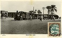
Khartoum – Wadi Halfa railway line
| Khartoum – Wadi Halfa | |||||||||||||||||||||||||||||||||||||||||||||||||||||||||||||||||||||||||||||||||||||||||||||||||||||||||||||||||||||||||||||||||||||||||||||||||||||||||||||||||||||||||||||||||||||||||||||||||||||||||||||||||||||||||||||||||||||||||||||||||||||||||||||||||||||||||||||||||||||||||||||||||||||||||||||||||||||||||||||||||||||||||||||||||||||||||||||||||||||||||||||||||||||||||||||||||||||||||||||||||||||||||||||||||||||||||||||||||
|---|---|---|---|---|---|---|---|---|---|---|---|---|---|---|---|---|---|---|---|---|---|---|---|---|---|---|---|---|---|---|---|---|---|---|---|---|---|---|---|---|---|---|---|---|---|---|---|---|---|---|---|---|---|---|---|---|---|---|---|---|---|---|---|---|---|---|---|---|---|---|---|---|---|---|---|---|---|---|---|---|---|---|---|---|---|---|---|---|---|---|---|---|---|---|---|---|---|---|---|---|---|---|---|---|---|---|---|---|---|---|---|---|---|---|---|---|---|---|---|---|---|---|---|---|---|---|---|---|---|---|---|---|---|---|---|---|---|---|---|---|---|---|---|---|---|---|---|---|---|---|---|---|---|---|---|---|---|---|---|---|---|---|---|---|---|---|---|---|---|---|---|---|---|---|---|---|---|---|---|---|---|---|---|---|---|---|---|---|---|---|---|---|---|---|---|---|---|---|---|---|---|---|---|---|---|---|---|---|---|---|---|---|---|---|---|---|---|---|---|---|---|---|---|---|---|---|---|---|---|---|---|---|---|---|---|---|---|---|---|---|---|---|---|---|---|---|---|---|---|---|---|---|---|---|---|---|---|---|---|---|---|---|---|---|---|---|---|---|---|---|---|---|---|---|---|---|---|---|---|---|---|---|---|---|---|---|---|---|---|---|---|---|---|---|---|---|---|---|---|---|---|---|---|---|---|---|---|---|---|---|---|---|---|---|---|---|---|---|---|---|---|---|---|---|---|---|---|---|---|---|---|---|---|---|---|---|---|---|---|---|---|---|---|---|---|---|---|---|---|---|---|---|---|---|---|---|---|---|---|---|---|---|---|---|---|---|---|---|---|---|---|---|---|---|---|---|---|---|---|---|---|---|---|---|---|---|---|---|---|---|---|---|---|---|---|---|---|---|---|---|---|---|---|---|---|---|---|---|---|---|---|---|---|---|---|---|---|---|---|---|---|---|---|---|---|---|---|---|---|---|---|---|---|
|
O&K steam locomotive No. 6, D2220 from 1907
| |||||||||||||||||||||||||||||||||||||||||||||||||||||||||||||||||||||||||||||||||||||||||||||||||||||||||||||||||||||||||||||||||||||||||||||||||||||||||||||||||||||||||||||||||||||||||||||||||||||||||||||||||||||||||||||||||||||||||||||||||||||||||||||||||||||||||||||||||||||||||||||||||||||||||||||||||||||||||||||||||||||||||||||||||||||||||||||||||||||||||||||||||||||||||||||||||||||||||||||||||||||||||||||||||||||||||||||||||
| Route length: | 919 km | ||||||||||||||||||||||||||||||||||||||||||||||||||||||||||||||||||||||||||||||||||||||||||||||||||||||||||||||||||||||||||||||||||||||||||||||||||||||||||||||||||||||||||||||||||||||||||||||||||||||||||||||||||||||||||||||||||||||||||||||||||||||||||||||||||||||||||||||||||||||||||||||||||||||||||||||||||||||||||||||||||||||||||||||||||||||||||||||||||||||||||||||||||||||||||||||||||||||||||||||||||||||||||||||||||||||||||||||||
| Gauge : | 1067 mm ( cape track ) | ||||||||||||||||||||||||||||||||||||||||||||||||||||||||||||||||||||||||||||||||||||||||||||||||||||||||||||||||||||||||||||||||||||||||||||||||||||||||||||||||||||||||||||||||||||||||||||||||||||||||||||||||||||||||||||||||||||||||||||||||||||||||||||||||||||||||||||||||||||||||||||||||||||||||||||||||||||||||||||||||||||||||||||||||||||||||||||||||||||||||||||||||||||||||||||||||||||||||||||||||||||||||||||||||||||||||||||||||
|
|||||||||||||||||||||||||||||||||||||||||||||||||||||||||||||||||||||||||||||||||||||||||||||||||||||||||||||||||||||||||||||||||||||||||||||||||||||||||||||||||||||||||||||||||||||||||||||||||||||||||||||||||||||||||||||||||||||||||||||||||||||||||||||||||||||||||||||||||||||||||||||||||||||||||||||||||||||||||||||||||||||||||||||||||||||||||||||||||||||||||||||||||||||||||||||||||||||||||||||||||||||||||||||||||||||||||||||||||
The Khartoum – Wadi Halfa railway was driven from Wadi Halfa to Khartoum in 1897 as a supply route for the British troops advancing against the Mahdists in Sudan from Wadi Halfa in a south-easterly direction, directly to Abu Hamed . Contrary to the original direction of construction, the route is now kilometer starting from Khartoum .
occasion
The central transport route in Sudan, given by nature, is the Nile . However, it is not navigable south of Aswan because it is interrupted by 6 cataracts between Khartoum and Aswan . For traffic, this meant a short distance of land transport and two reloading to and from the river boats. This made the transport more expensive and extended transport times enormously. Both of these were extremely hindering the British in their fight against the Mahdists. The Wadi Halfa – Kerma railway line , which only bypassed the second and third cataracts and ended far west of Khartoum, was not really helpful.
construction
The stretch from Wadi Halfa to Khartoum cut the lower knee arch of the Nile by the shortest route. South of Abu Hamed, where it reached the Nile again, it leads along its right bank via Atbara (then: Berber ) to Khartoum. The gauge was chosen based on the first railroad in Sudan from Wadi Halfa to Kerma Kapspur . In 1899 the railway reached Khartoum after 917 km. It was put into service in full on January 4, 1900. The track runs on level ground so that - with one exception - there were no major obstacles in the way of construction. The exception was the crossing of the Atbara , a right tributary of the Nile, which required a 380 m long bridge. From 1906, the line received a branch line to Meroe , with which the fourth cataract of the Nile was bypassed and the Nile valley was opened up between the third and fourth cataracts.
meaning
The Wadi Halfa – Khartoum line was and still is the central artery of the Sudanese railway network, even if the importance of rail transport in Sudan has declined drastically over the past three decades. It is the only route on which regular passenger services are still offered.
Events
On February 26, 1965, a freight train heading for Khartoum and the passenger train from Khartoum to Port Sudan collided near the village of Miseiktab . 100 people died and 29 were injured.
literature
- Franz Baltzer : The colonial railways with a special focus on Africa . 1916. ND Holzminden o. J. ISBN 978-3-8262-0233-9
- Neil Robinson: World Rail Atlas and Historical Summary 7 = North, East and Central Africa. 2009. ISBN 978-954-92184-3-5
Individual evidence
- ↑ Miseiktab is about 100 km north of Khartoum (16 ° 20'28 "N, 32 ° 43'29" E).
- ↑ From the English language Wikipedia, there without further evidence .


