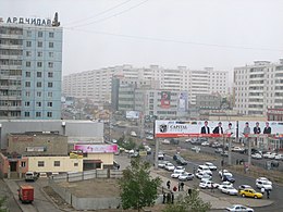
Bajangol (District)
|
Bajangol Баянгол English Bayangol |
||

|
||
| Country: |
|
|
| Aimag : | Ulaanbaatar (Capital District) | |
| Local community: | Ulaanbaatar | |
| Coordinates: | 47 ° 55 ' N , 106 ° 55' E | |
| Surface: | 29.5 km² | |
| Residents: | 160,479 | |
| Population density: | 5,440 inhabitants per km² | |
| Time zone: | UTC + 8 | |
| Telephone code: | +976 (0) 11 | |
| Post Code: | 210 xxx | |
| License Plate: | УБ_ (_ variable) | |
| Community type: | Düüreg | |
| Structure: | 20 khoroos | |
| Website: | ||
|
|
||
Bajangol ( Mongolian Баянгол "Great River" ) is one of nine Düüregs (districts) in the Mongolian capital Ulaanbaatar .
During the communist awakening after the October Revolution in Russia , to which Mongolia belonged at the time, the Bajangol district was called "Октябрийн район" (October District).
population
160,479 people live in Bajangol, and Bajangol is subdivided into a total of twenty Khoroos (subdistricts).
Town twinning
A partnership with the community of Schönefeld in Brandenburg has existed since 1999 .
Web links
- Official website of Bajangol , in Mongolian language.

