
Baku Bay
| Baku Bay | |
|---|---|
 Baku Bay and Baku City Center |
|
| Waters | Caspian Sea |
| Land mass | Abşeron |
| Geographical location | 40 ° 21 ' N , 49 ° 53' E |
 |
|
| surface | 50 km² |
| Coastline | 20 km |
| Medium water depth | 4 m |
| Islands | Pestschany , Dasch Sirja , Bojuk Sirja |
| Tributaries | Kura |
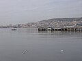
The Bay of Baku ( Azerbaijani Bakı körfəzi ) is a natural harbor of the Caspian Sea , which is located on the southern coast of the Abşeron Peninsula in Azerbaijan . On the bay are the Baku International Sea Trade Port , the naval base of the Azerbaijani naval forces and the local yacht club.
description
The length of the coastline is 20 km. The bay is bounded to the east by Cape Sultan Burnu, to the southwest by Cape Schichow and to the east and southeast by the islands of Pestschany , Dasch Sirja and Bojuk Sirja . These islands are part of the Baku archipelago, which for the most part stretches across the bay. During strong storms, the wave amplitude in the bay can be up to 1.5 m. Baku's beach boulevard, Baku Bulvar, runs along the bay .
history
Baku Bay was silted up from the 1st to the 7th centuries AD, and today's islands were connected to the mainland. On Ptolemy's maps from the 2nd century, Baku was depicted far from the sea. After the 7th century to the 9th century, the sea level began to rise and Baku Bay was formed. During the Middle Ages from the 10th to the 13th centuries, the level of the Caspian Sea rose by around 10 m. The 14th century Italian geographer Marino Sanudo stated: "The Caspian Sea rises a hand's breadth every year and many good cities have already sunk". According to a report by the geographer Abd al-Raschid al-Bakui from 1403, parts of Baku were flooded and the water was near the Mohammed Mosque . At that time, the sea was at the foot of the Maiden's Tower and already completely covered Sabayil Castle, which was built on a rock in Baku Bay. Sea levels fluctuated at this high level for the next 600 years before beginning to fall at the beginning of the 20th century.
Assumptions that deformations of the sea floor could be the cause of the fluctuations have been refuted. The most likely cause of this phenomenon is climate change. Since the sea has no connection to oceans, the water balance is regulated solely by rivers and precipitation as well as evaporation. As a result, the inflow was higher during the time of the strong increase. The Volga is of particular importance , with an inflow of around 80%. This amount is in turn largely determined by the annual snowmelt. It has been calculated that in years with a lot of snow the river brings about 300 to 350 km 3 of water to the sea and the water level rises in those years. In weak years, however, it is only 150 to 200 km 3 and the sea level falls. On the other hand, a rise in water leads to flooding, which in turn increases the surface area and increases the amount of evaporation. The Soviet geographer LS Berg noted that during periods of Arctic warming, the sea level of the Caspian Sea falls and that of the Aral Sea rises. Conversely, when the Arctic cools, the level of the Caspian Sea increases and that of the Aral Sea decreases.
ecology
Baku Bay is heavily polluted. The reasons for the deteriorating ecological condition of the bay are diverse. In particular, waste from coastal industrial, residential and service properties, ship operations and deposits from oil and gas production make a decisive contribution to this. Exploration work on the bay's seabed began after 1996. From 2007 to 2009, the water was cleared on a large scale from metal structures, sunken ships, unused hydrotechnical systems and underwater pipes. A total of around 4,500 tons of scrap and 412 tons of wood waste were recovered.
Ports and bridges
The sea trading port extends along the north and west banks of the bay. The ferry port is located in the northwestern part . The construction of an approximately 14 km long bridge over the bay valued at US $ 2.5 billion by Korean experts is planned to relieve the coastal road. It is to be built on high pillars to allow shipping to continue.
gallery
Baku Bay

seaport

Yacht club

Baku Bay 1862


literature
- Azerbaijan Soviet Encyclopedia . tape 1 , 1976.
Individual evidence
- ↑ Изменения уровня Каспийского моря. Retrieved January 1, 2013 (Russian).
- ↑ a b c Б.А. Шлямин: Каспийское море . Географгиз, 1954, p. 128 (Russian, online [accessed February 1, 2013]).
- ^ Environmental problems of the Caspian Sea. (No longer available online.) Ministry of Ecology and Natural Resources of Azerbaijan Republic, archived from the original on Aug. 24, 2012 ; accessed on January 1, 2013 . Info: The archive link was inserted automatically and has not yet been checked. Please check the original and archive link according to the instructions and then remove this notice.
- ↑ Sunken ships cleared from Baku bay. ann.az, December 8, 2011, accessed January 1, 2013 .
- ↑ Florian Schröder: Business Day Azerbaijan and Central Asia. (PDF; 11.8 MB) (No longer available online.) Hanover Chamber of Commerce and Industry, March 24, 2011, formerly the original ; accessed on January 1, 2013 . ( Page no longer available , search in web archives ) Info: The link was automatically marked as defective. Please check the link according to the instructions and then remove this notice.