Banda Neira
| Banda Neira | ||
|---|---|---|
| Banda Neira in the center of the Banda Islands | ||
| Waters | Banda Lake | |
| Archipelago | Moluccas | |
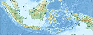
| Geographical location | 4 ° 31 '33 " S , 129 ° 53' 51" E | |
|
|
||
| length | 3.3 km | |
| width | 1.3 km | |
| surface | 3 km² | |
| Highest elevation | Papenberg 250 m |
|
| Residents | 14,000 4667 inhabitants / km² |
|
| main place | Banda Neira | |
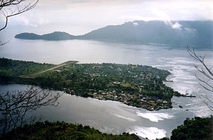
| View from Banda Api to Banda Neira with the main town on the right and the runway on the left. In the background the neighboring island of Banda Besar. | ||
Banda Neira , also Pulau Naira , is an Indonesian island, belongs to the Banda Islands and is part of the Moluccas , Maluku Utara Province .
It is located in the Banda Sea , 160 km south of Seram Island . Its north-south length is approximately 3.3 km and its width is 1.3 km. The neighboring island of Banda Api is only 100 meters to the west and Banda Besar is 1.5 km to the south or southeast . The highest point is the Papenberg at 250 meters.
Banda Neira is the main island of the Banda Islands and has a small airfield. A total of around 14,000 people live on the island.
In the south lies the main town of the same name, which is the largest town in the archipelago with around 7,000 inhabitants. At the height of the nutmeg spice trade , which at that time only grew on the Banda Islands, Bandaneira was an important trading center. The old Dutch fort Belgica (Indonesian: Benteng Belgica) has been fully restored and has been a UNESCO World Heritage Site since 1995 .
history
Until the early 17th century, the Banda Islands were ruled by locals, the Orang Kaya (which means: "rich man"). The Portuguese were the first Europeans to dominate the spice trade. In 1609 the Dutch built Fort Nassau (Indonesian: Benteng Nassau) on Banda Neira , and in 1611 they built the larger Fort Belgica .
In 1621 the newly appointed Governor General of the Vereenigde Oostindische Compagnie , Jan Pieterszoon Coen , conquered the islands and thereby also ended the rule of the Orang Kaya. The population was killed or enslaved; many Bandanese fled to other islands, including the Kai Islands .
English troops captured Banda Neira in 1810, but later returned the islands to the Dutch.
From January 1936 to February 1942, the two independence fighters and later Indonesian politicians were Mohammad Hatta and Sutan Sjahrir from the Dutch colonial power to exile in Banda Neira sent - after previously since January 1935 in Boven Digoel on Papua and then to March 1942 in Sukabumi on West Java had to spend. The houses of the two politicians can be visited.


