Banda Api
| Banda Api | ||
|---|---|---|
|
Banda Api volcano |
||
| height | 640 m | |
| location | Banda Islands , Indonesia | |
| Coordinates | 4 ° 31 '30 " S , 129 ° 52' 17" E | |
|
|
||
| Type | Caldera | |
| Last eruption | 1988 | |
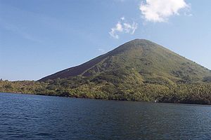
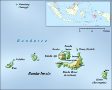
The Banda Api volcano forms the Indonesian island of the same name, which belongs to the Banda Islands , which in turn are part of the Moluccas and lie in the Banda Sea .
The active volcano (Indonesian: Gunung Api Banda or Gunung Api ) is 640 meters high and is located within two calderas . It lies in the center of the inner caldera with a diameter of about 3 kilometers, which is located in the southwest of a caldera with a diameter of 7 kilometers, which is largely flooded by the sea. At the same time, the Banda Api is the northern end of the Bandabogen , a chain of volcanic islands.
The island is approximately circular and has a diameter of about 3 kilometers. The neighboring island of Banda Neira is about 100 meters to the east , and Banda Besar is about one kilometer to the south .
Outbreaks of Banda Api was explosive in part; several lava flows reached the coast. Between 1586 and 1988 the volcano erupted over twenty times. For example, in June 1820 there was a sudden and violent eruption, as a result of which the islanders fled to Banda Neira . Accompanied by an underground rumble, a new crater arose in 1890 ; at the same time, there was a series of earthquakes in which many houses were damaged. In May 1901, strong earthquakes were accompanied by detonations and a bright glow at the top of the volcano.
The most recent eruption between May 9th and 17th, 1988 was preceded by a number of earthquakes. On site, the height of the eruption column on May 9th was estimated at 3 to 5 kilometers; Satellite measurements indicate an altitude of over 16 kilometers. To the south, north, and northwest of the summit, three craters formed, from which lava flows emerged, all of which reached the sea. The 1,800 islanders, as well as 5,000 of the then 6,000 residents of the city on the island of Banda Neira, were evacuated to the island of Ambon, around 200 kilometers away . The evacuation of Banda Neira was lifted on June 13th. Three people died as a result of the volcanic eruption.
Web links
- Banda Api in the Global Volcanism Program of the Smithsonian Institution (English)
- Banda Api at east-indonesia.info (English)
Individual evidence
- ^ Christopher G. Newhall, Daniel Dzurisin: Historical unrest at large calderas of the world . (PDF; 37.0 MB) USGS Bulletin 1855, 1988, pp. 339-344 (English).
- ^ Banda Api - Eruptive History in the Global Volcanism Program (accessed February 10, 2013).
- ^ David Ritchie, Alexander E Gates: Encyclopedia of Earthquakes and Volcanoes. New Edition. Checkmark Books, New York 2001, ISBN 0-8160-4583-6 , p. 21.
- ↑ Banda Api - Monthly Reports in the Global Volcanism Program (English), accessed on February 10, 2013.


