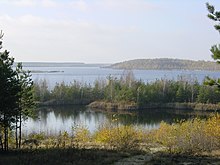
Barbara Canal
The Barbarakanal (bridge 9) is an artificially created navigable waterway in the northern Saxon community of Elsterheide . The canal is located between the Geierswalder See and the Partwitzer See near Geierswalde . It is an artificially created canal in the Lusatian Lakeland and connects two lakes created from former lignite opencast mining . The 1150 meter long canal with a bed width of four meters and a water capacity of five cubic meters per second was inaugurated in December 2003. It runs from the northern tip of the Geierswalder to the western shore of the Partwitzer See. Its name refers to the patron saint of miners, Saint Barbara .
task
In addition to the touristic task, the canal is intended to rehabilitate the region's water balance. Furthermore, the water balance is to be restored and the drainage conditions from the remaining chain of holes in the post-mining region to the Schwarze Elster and Rainitza receiving waters are to be secured. The canal makes it easier and faster to flood the lakes, as flooding with rising groundwater would take several decades. A bank erosion takes place so only to a limited extent.
There is a double gate weir on the canal. At this point it is crossed by a cycle path, a former farm road of the Lausitzer and Mitteldeutsche Bergbau-Verwaltungsgesellschaft (LMBV). The bridge is 29.7 meters long and has a clearance of 6 meters. A figure representing Saint Barbara is incorporated into the railing of the bridge. The work was carried out on behalf of the LMBV.
Individual evidence
- ↑ Information brochure of the LMBV Landschaftswandel ( page no longer available , search in web archives ) Info: The link was automatically marked as defective. Please check the link according to the instructions and then remove this notice. (Download as PDF)
- ↑ Homepage of the Lausitzer Seenland ( Memento of the original from October 7, 2007 in the Internet Archive ) Info: The archive link was inserted automatically and has not yet been checked. Please check the original and archive link according to the instructions and then remove this notice.
- ↑ Information brochure, Landscapes in Transition - Lausitzer Seenland; published by the LMBV 12/2007
- ↑ LMBV homepage ( page no longer available , search in web archives ) Info: The link was automatically marked as defective. Please check the link according to the instructions and then remove this notice.
- ↑ LMBV homepage ( page no longer available , search in web archives ) Info: The link was automatically marked as defective. Please check the link according to the instructions and then remove this notice.
Coordinates: 51 ° 31 ′ 18 ″ N , 14 ° 7 ′ 21 ″ E

