
Barranco de Las Angustias

The Barranco de las Angustias (" Gorge of Fears ") drains the Caldera de Taburiente, which is over 1000 meters high, in the center of the Canary Island of La Palma and extends over a length of about ten kilometers to the Atlantic at Puerto de Tazacorte .


geography
The multitude of spring waters that arise in the caldera combine in the Barranco to form the Río de Taburiente and Río Almendro amargo . They unite in Dos Aguas , most of the water is discharged shortly afterwards at a water intake for irrigation purposes. Below this water intake, the Barranco only seldom carries visible water. In winter and even if there is only brief heavy rain in the caldera, it can develop into a raging river with considerable erosion effects. Thanks to the abundance of water, three water mills were operated in the Barranco, one immediately below the church "Iglesia de Nuestra Señora de Las Angustias" and two near Tío Quiterio.
The upper part of the Barrancos is part of the Caldera de Taburiente National Park . On June 19, 1987, the Barranco de Las Angustias was declared a natural park by law.
In the Barranco there are extensive avocado and banana plantations as well as inhabited areas, Puerto de Tazacorte, residential areas of Los Llanos de Aridane on the south slope and the Amagar part of Tijarafe on the upper north slope .
The country road (LP-1) overcoming the wide valley connects the municipalities of Los Llanos de Aridane and Tazacorte on the south side with the north-western part of La Palma. The pilgrimage church "Nuestra Señora de las Angustias" is located about two kilometers upstream of the mouth. The river bed in the upper part of the Barranco de Las Angustias can be reached via an access road from Los Llanos and forms the starting point for hikes in the Barranco up to the Caldera de Taburiente . The road continues to the no longer permanently inhabited settlement of La Caldera (or Casas del Cura ), it ends at the Los Brecitos turning point .
In November 2001, when heavy rain suddenly set in, three German vacationers were killed in the gorge below Dos Aguas due to the raging mass of water.
geology
The Caldera de Taburiente and the Barranco de Las Angustias were created around 500,000 years ago through tectonic processes, beginning with the collapse of the western flank of the original Taburiente volcano. In the period that followed, both were steadily expanded and deepened by erosion. Huge, polished rocks in the river bed are evidence of this energy.
Characteristic are the almost vertical walls of the Barranco, up to 1000 meters high, on its north side. Their tectonics provide information about the volcanic history of the island. On its south side is the mighty, 1854 meter high Pico Bejenado, a no longer active volcano. Pillow lava can be found in the river bed of the Barranco today . It occurs when magma escapes underwater and quickly solidifies on the surface. It is therefore considered a sure indicator of submarine volcanism on La Palma.

View of the north slope from the "Lomo del Caballo" towards Puerto de Tazacorte

North slope with pronounced whirlpools

Riverbed
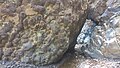
Rocks with pillow lava at Salto de la Estrechura

Pillow lava

»Dos Aguas«, water intake

River bed below the church of Nuestra Señora de las Angustias after heavy rain


Individual evidence
- ↑ GEQUO travel magazine: PLAYA DE TABURIENTE & CAMPINGPLATZ
- ↑ Molinos de La Palma , Palmeros en El Mundo (accessed on January 5, 2019).
- ↑ Paisaje Protegido del Barranco de Las Angustias (Protected Landscape of the Barranco de Las Angustias)
- ↑ LEY 12/1987 (Law 12/1987) , Espacios Naturales de Canarias.
- ↑ Three Germans killed on La Palma in severe weather , FAZ, November 22, 2001
- ↑ [1] , R. Olzem: Die Caldera de Taburiente, 2012.