
Los Llanos de Aridane
| Los Llanos de Aridane municipality | |||
|---|---|---|---|
_01_ies.jpg) Los Llanos in the Aridane Valley
|
|||
| coat of arms | Map of the Canary Islands | ||

|
|
||
| Basic data | |||
| Autonomous Community : | Canary Islands | ||
| Province : | Santa Cruz de Tenerife | ||
| Island: | La Palma | ||
| Coordinates | 28 ° 39 ′ N , 17 ° 55 ′ W | ||
| Height : | 325 msnm | ||
| Area : | 35.79 km² | ||
| Residents : | 20,467 (Jan 1, 2019) | ||
| Population density : | 571.86 inhabitants / km² | ||
| Founding: | 1812 | ||
| Postal code : | E-38760 (Los Llanos) E-39767 (Argual) E-38768 (Retamar) E-38769 (Puerto Naos) |
||
| Municipality number ( INE ): | 38024 | ||
| administration | |||
| Mayor : | Noelia García Leal ( PP ) | ||
| Address of the municipal administration: | Plaza de España, s / n 38760 Los Llanos de Aridane |
||
| Location of the municipality | |||

|
|||

Los Llanos de Aridane is one of the 14 communities on the Canary Island of La Palma, which belongs to Spain , and is located on the west side of the island in the middle of the Aridanetal .
The administrative center of the municipality is located in the town of the same name, Los Llanos de Aridane (known as such since 1899), the center of which lies at an altitude of 325 meters above sea level.
history
Los Llanos de Aridane was founded in August 1812 and together with El Paso , Tazacorte and Argual formed the community of the same name. On April 13, 1837, the Canarian Government proposed to merge El Paso with Tacande and the surrounding area to form a municipality with its own town hall, independent of Los Llanos. A few months later the project was realized and Los Llanos lost a considerable part of its size. On September 16, 1925, during the rule of Primo de Rivera, Tazacorte was also excluded from Los Llanos. At that time, Tazacorte was with 2316 inhabitants the most populous part of the municipality with the greatest economic growth.
The municipality of Los Llanos de Aridane has developed over the years to become the most populous on the island and thus surpassed the municipality of Santa Cruz de La Palma with the island capital of the same name in the 1990s .
Puerto Naos , part of the municipality of Los Llanos , is one of the two tourist centers of La Palma , along with Los Cancajos in the municipality of Breña Baja . Today Los Llanos de Aridane is the most important economic center in the west of the island.
character
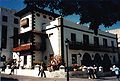
The character of Los Llanos is shaped by the Plaza de España in the center of the village with the three-aisled parish church Nuestra Señora de Los Remedios from the 16th century, partly in the Mudéjar style, the town hall ( Ayuntamiento ) built in 1945 in the regional style and the adjacent ones Streets like the pedestrian street of Calle Réal (formerly Calle del General Franco ). Several mighty Chinese figs in Plaza de España and Avenida Dr. Flamingos were brought with them by Cuban emigrants in 1863 and provide shade for the street cafes on the square, which locals and tourists like to visit.
In the west of Los Llanos the district of Argual borders. In the area of the village square of Argual ( Plaza Sotomayor ) the Spanish conquerors built their first settlement at the end of the 15th century. With the sugar cane cultivation , the resident noble families acquired an immense fortune in the 16th and 17th centuries. Most of their manor houses are still preserved on the village square. For sugar production, the Monteverde family operated a sugar cane mill in Argual , which was powered by the water from the caldera. The water was channeled through the aqueduct , which was built between 1555 and 1557 and is still partially preserved today .
Worth seeing is the in the district of Las Manchas situated Plaza de La Glorieta with its mosaics and plantings that of Luis Morera , a student of César Manrique designed.
In the Barranco de Las Angustias , a nature reserve , is the pilgrimage church of Nuestra Señora de las Angustias from the 16th century.
The extinct volcanoes in the districts of Argual , Triana , La Laguna and Todoque are protected as natural monuments.
In the lava field that spilled over Todoque to the sea with the eruption of the San Juan volcano in 1949 , several lava tunnels have formed, of which the Cueva de las Palomas and Cueva El Vidrio have been accessible since 2017.
Ayuntamiento (Town Hall) from Los Llanos

Nuestra Señora de Los Remedios

Street in Los Llanos
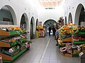
Market hall in Los Llanos

Acueducto de Argual in Calle Los Molinos

Nuestra Señora de las Angustias
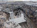
Access to the Cueva de las Palomas volcanic tube


Plaza de La Glorieta, 2006

View from Todoque to the west coast, June 2006


Museums
- Archaeological Museum Museo Arqueológico Benahoarita . It has been showing exhibits from the time of the Benahoaritas on La Palma since 2007 .
- Wine museum Casa Museo del Vino in Las Manchas .
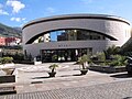
- In the lava field of the Llano del Banco volcano, the visitor center Centro de interpretation de las cavidades volcanicas Canos de Fuege was built in 2017 and opened in April 2019. Below the building there is access to a walkable section of the approximately 15 meter long El Vidrio volcanic tube .
Botanical Garden
The Parque Antonio Gómez Felipe (also: El pequeño jardín botánico ) is a small botanical garden in Los Llanos on the Ctra. Puerto Naos and was designed by Luis Morera and Natan Teuch in 2010. The special attraction of the garden lies in the combination of bizarre lava rocks with mainly endemic plants to create aesthetically pleasing structures. (Luis Morera designed other parks and squares on La Palma.)
Museo Arqueologico in Los Llanos

Casa Museo del Vino in Las Manchas

Visitor center in the lava field of the San Juan volcano

Botanical Park ( Jardín botánico )


Places of the community

The population figures are as of January 1, 2013.
- Argual (2,614)
- La Laguna (1,632)
- Las Manchas (889)
- Los Barros (2,136)
- Los Llanos de Aridane (3,630)
- Montaña Tenisca (2,520)
- Puerto Naos (946)
- Retamar (2,611)
- Tajuya (712)
- Todoque (1,426)
- Triana (1,814)
Population development
|
|
Web links
Individual evidence
- ↑ Cifras oficiales de población resultantes de la revisión del Padrón municipal a 1 de enero . Population statistics from the Instituto Nacional de Estadística (population update).
- ↑ a b c Los Llanos de Aridane ( Memento of the original from July 27, 2017 in the Internet Archive ) Info: The archive link has been inserted automatically and has not yet been checked. Please check the original and archive link according to the instructions and then remove this notice. , Palm Eros en el mundo.
- ↑ Los Llanos De Aridane. In: Guiapueblos.es. Retrieved November 14, 2011 .
- ↑ www.eldiario.es: You present an unpublished photo of the sowing of the first Indian laurels from Los Llanos in 1863
- ↑ El azúcar y su cultura en las islas atlánticas, 500 Años de La Palma y Flandes (1513-2013) , Vol. 1 , Jesus Pérez Morera on the website Memorial Digital de Canarias (accessed on December 13, 2017)
- ↑ Susanne Lipps-Breda: La Palma travel guide , DuMont travel paperback, 2017.
- ↑ Santuario de Ntra Sra de Las Angustias , La Palma Reserva Mundial de la Biosfera.
- ↑ El Centro de Interpretación de las Cavidades Volcánicas Caños de Fuego abre sus puertas al público , EL APURON, April 12, 2019.
- ↑ Website of the Spanish Statistical Office ( Instituto Nacional de Estadística )