
Garafía
| Garafía municipality | |||
|---|---|---|---|
| coat of arms | Map of the Canary Islands | ||

|
|
||
| Basic data | |||
| Autonomous Community : | Canary Islands | ||
| Province : | Santa Cruz de Tenerife | ||
| Coordinates | 28 ° 49 ′ N , 17 ° 55 ′ W | ||
| Height : | 365 msnm | ||
| Area : | 102.99 km² | ||
| Residents : | 1,667 (Jan 1, 2019) | ||
| Population density : | 16.19 inhabitants / km² | ||
| Postal code : | 38787 | ||
| Municipality number ( INE ): | 38016 | ||
| administration | |||
| Mayor : | Yeray Rodríguez Rodríguez ( PSOE ) | ||
| Website : | www.garafia.org | ||
| Location of the municipality | |||

|
|||

Garafía (full name: Villa de Garafía ) is the northernmost of the 14 municipalities of the to Spain belonging Canary Island of La Palma . The administrative seat is in Santo Domingo de Garafía .
geography
The municipality has a coastal landscape of cliffs , rock faces and cliffs with almost no beaches, interrupted by mouths of deep gorges . In the country at altitudes of about 300 meters there are small villages, agricultural areas and groves of dragon trees . The forests of the robust Canarian pine (pinus canariensis) stretch from 600 meters to the tree line at around 2000 meters . Above the tree line, there is a high mountain climate with the island's highest, often snow-capped summit in winter, the 2426-meter-high Roque de los Muchachos with international star observatories , which have the best viewing conditions with clean air and hardly any strange light.
The administrative center of Santo Domingo de Garafía is about 350 meters above sea level and is a small village with steep streets, traditional houses and a typical plaza in the center.
From the place a road goes towards the coast to the so-called Puerto de Garafia , a natural harbor with a small bay, in front of the three rocky islands Los Guinchos .
A specialty is the place El Tablado , about 5 km as the crow flies and 20 km by road from Santo Domingo de Garafía . His houses (old fincas) are densely packed on a 300 meter high, tableau-like mountain saddle, nestled between two gorges above the cliff.

History and culture
After the conquest of La Palma, the north of the island was populated by the Spanish crown mainly with Portuguese, mainly Jews expelled from Portugal. The areas at medium altitudes assigned to the settlers since 1579 were linked to the condition that one fifth of the income generated was given to the landlord. This taxation system lasted for a long time.
For centuries Garafía has had a tradition of pasture farming. The natives of Garafía already did this hard work, with the goat herds above all making a living. The bell-ringing of the animals served the goatherds to locate the animals in the rugged terrain. With the long shepherd's stick, which the natives used, the shepherds were able to overcome the difficult terrain with great skill. The shepherd's leap (Spanish: Salto del pastor) has become a popular sport in the Canary Islands.
The cheese made from goat's milk is a popular product with palm trees and tourists and represents an important source of income for local agriculture.
In 1812 Garafía was declared a municipality and got in 1906 by King Alfonso XIII. awarded the city title.
A folklore museum in the community's cultural center gives an insight into the history and traditions, nature parks and hiking opportunities, archeology and finally the observatory on the Roque de Los Muchachos.

Alley in Santo Domingo de Garafía
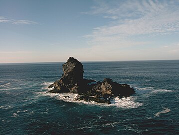
Roque de Santo Doming of the Los Guinchos rock group

El Tablado

Observatories

Church of the Señora de La Luz in Santo Domingo de Garafía


Windmills

In Garafía there are still several windmills in different states of preservation, which the inhabitants used to grind grain, especially the Gofio . None of the mills are still in operation. The El Molino de Las Tricias from 1868 was operated until 1953 and restored in 2000 in the typical wooden construction with a 9 to 10 meter high tower. Today there is a museum in the mill, which shows the technical equipment of the mill and a 1:10 model of the mill.
La Zarza cultural park

There are numerous archaeological sites in the municipality of Garafía. In the cultural park La Zarza ( Parque Cultural La Zarza ), which is located in the middle of a moist forest area with imposing mossy trees about 5 km northwest of the village on the road LP-1, there is one of the most important Canarian sites with rock engravings, spirals and meanders by the indigenous people ( Benahoaritas ). An exhibition in the park provides information about the pre-Hispanic natives. The park has been closed since 2017 until further notice.
religion
A little below Santo Domingo de Garafía is the church of the Señora de La Luz with its main nave from the 16th century. The aisle was built 100 years later. In this church there is the image of the Virgin of Light (Señora de La Luz).
The 16th century pilgrimage chapel in San Antonio del Monte is decorated for festivities every Saturday around June 13th. The large Portuguese community had taken over the patron saint of Portugal San Antonio de Padua for Garafía. The procession of St. Anthony takes place with music, food and wine. This includes the traditional cattle market.
Traffic development
For a long time the municipality of Garafía was considered to be remote. The Caminos Reales run through Garafía, these partly well-developed paths were the main traffic routes in the region until the 1960s. Goods and loads were transported on donkeys to the boat docks on the coast. It was not until the 1990s that the road network was asphalted to such an extent that the neighboring communities were relatively easy to reach. Smaller places on the rugged north coast can only be reached today via unpaved slopes.
Population and places of the municipality

The population figures in brackets are from 2013.
- Santo Domingo de Garafia (448)
- Las Tricias (262)
- El Castillo (104)
- Cueva del Agua (160)
- Cateta
- Santa Domingo
- Llano Negro (90)
- Hoya Grande (71)
- El Palmar (63)
- Juan Adalid-El Mudo (38)
- Don Pedro (39)
- La Mata (50)
- El Tablado (38)
- Roque del Faro (99)
- Franceses (183)
There has been a sharp decline in the population since the 1950s (1950 to 2013: - 66.3%).
|
|
Web links
Individual evidence
- ↑ Cifras oficiales de población resultantes de la revisión del Padrón municipal a 1 de enero . Population statistics from the Instituto Nacional de Estadística (population update).
- ↑ a b Rolf Goetz: La Palma, active vacation on the greenest of the Canary Islands. 5th edition. Peter Meyer travel guide, Frankfurt am Main 2000.
- ↑ Archived copy ( Memento of the original from March 4, 2016 in the Internet Archive ) Info: The archive link was inserted automatically and has not yet been checked. Please check the original and archive link according to the instructions and then remove this notice. , Villa de Garafía.
- ^ Museo Etnográfico
- ↑ Pasado y Futuro del Molino de Las Tricias , En Las Tricias, July 26, 2011.
- ^ Parque Cultural La Zarza y La Zarcita
- ↑ INEbase (database of the Instituto Nacional de Estadística)