
Tazacorte
| Tazacorte municipality | |||
|---|---|---|---|

|
|||
| coat of arms | Map of the Canary Islands | ||

|
|
||
| Basic data | |||
| Autonomous Community : | Canary Islands | ||
| Province : | Santa Cruz de Tenerife | ||
| Island: | La Palma | ||
| Coordinates | 28 ° 39 ′ N , 17 ° 56 ′ W | ||
| Height : | 107 msnm | ||
| Area : | 11.36 km² | ||
| Residents : | 4,575 (Jan 1, 2019) | ||
| Population density : | 402.73 inhabitants / km² | ||
| Founding: | 1925 | ||
| Postal code : | 38770 | ||
| Municipality number ( INE ): | 38045 | ||
| Nearest airport : | La Palma airport on the east side of the island | ||
| administration | |||
| Official language : | Castilian | ||
| Mayor : | Ángel Pablo Rodríguez Martín (Unión Bagañete-CC) | ||
| Address of the municipal administration: | Calle Primero de Mayo, 1 | ||
| Website : | www.tazacorte.es | ||
| Location of the municipality | |||

|
|||

Tazacorte (officially: La Villa y Puerto de Tazacorte ) is one of the 14 municipalities of the island of La Palma , one of the politically Spain , geographically Africa belonging to the Canary Islands in the Atlantic Ocean. Puerto de Tazacorte is the place where the Spanish conquest of La Palma began in 1492. Due to its good climatic location, the conquerors began growing sugar cane at an early stage, which provided the community with a profitable economy for three centuries. The mansions that still exist today bear witness to this development. The main livelihoods of the community today are extensive banana plantations and gentle tourism. Special features of the community are the historic staircase district in Villa de Tazacorte and the fishing and yachting port in Puerto de Tazacorte.
geography
Geographical location and geology
_01_ies.jpg)
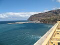
The Tazacorte plateau lies in the west of the Aridanetal directly on the Atlantic Ocean . At its northern end is the Barranco de Las Angustias, declared a nature reserve, the drain from the Caldera de Taburiente , bordering the municipality of Tijarafe . To the east and south, Tazacorte is surrounded by the municipality of Los Llanos de Aridane .
The lava of the Tacande volcano (Montaña Quemada, Burnt Mountain) and that of the San Juan volcano have shaped the landscape of Tazacorte. During its last eruption in 1949, the San Juan enlarged the land at the southern end of the municipality, where the Faro de Punta Lava lighthouse was also built on the large lava platform . Furthermore, the landscape is characterized by banana plantations and four volcanoes standing in a row (from north to south) Montaña Argual (323 meters), Montaña Triana (353 meters), Montaña La Laguna (339 meters) and Montaña Todoque (348 meters) . The volcanoes are under nature protection and form the Monumento Natural de los Volcanes de Aridane .
Of the more than one hundred volcanic caves on La Palma, five are in the area of Tazacorte: the Cueva de Hércules, the Cueva de Los Caracoles (both north of the Montaña La Laguna), the Cueva de El Perdido (with four openings to the cliff), the Cueva La Muralla and the Cueva de la Terraza de Verano (both in the south of La Costa). The Cueva de El Perdido with an extension of 1288 meters is after the Cueva Honda del Bejenado (El Paso municipality, 1362 meters) the most widely branched volcanic tube of La Palma.
Parish parts

_03_ies.jpg)
The municipality of Tazacorte consists of the municipality parts (from north to south) El Puerto (also called: Puerto de Tazacorte), Tarajal, Tazacorte (also called: Villa de Tazacorte), Cardón, San Borondón, Marina and La Costa. Only in the municipality parts of Villa de Tazacorte and Puerto de Tazacorte there are villages, in all other parts of the municipality there are only scattered houses .
Villa de Tazacorte
The place Tazacorte is the administrative center of the municipality and the infrastructural core. Here traditional building styles mix with modern architecture. Old houses, in Canarian or colonial style, with narrow streets predominantly paint the image of the place, which is also called "Paris chiquito" (Little Paris). The El Charco neighborhood was the original center where the Monteverde family established a successful sugar factory. The place grew with apartments for employees, mills and workshops and other farm buildings.

Villa de Tazacorte, on the left the El Charco district, in the center the church

Tazacorte - old town, view in north direction

Plaza de España with the Iglesia San Miguel Arcángel

Interior of the Iglesia San Miguel Arcángel

Tazacorte - old town, benches next to the church

Town hall, in front of the fountain San Miguel de La Palma


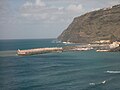
Puerto de Tazacorte


The place El Puerto is at the end of the Barranco de Las Angustias. The current fishing and yachting port was built from 1976 to 1981 south of the old port, at the mouth of the Barranco de Tenisca (in the neighboring district of Tarajal) and is the largest port on the island. From 1999 to 2003 the port was expanded and the old pier to protect the beach was expanded. There is a marina here. The new pier protects the beach in particular from the waves, some of which are several meters high. Another port extension was designed for ferry and cruise ship traffic, but is currently not in use.
At the site of the dike, a breakwater was built in 1936 to protect the first port of Tazacorte, from which bananas were exported. A suitable road connection to the port of the island's capital Santa Cruz de La Palma did not exist at that time.
El Puerto and Tarajal together have a two-kilometer long beach made of black lava sand with a correspondingly long promenade. With 3500 hours of sunshine a year, Puerto de Tazacorte is the sunniest place on the island. Los Tarajales beach near the port has been open to nudists since 2014 .
Meaning of the place name
The first inhabitants of La Palma, the Benahoaritas , are likely to have immigrated from the south-west of Morocco. The name Tazacorte is derived from the Berber term askar , azaġar or similar ( Eng . "Plain", "flat pasture") or from tizekkar : "parcel".
history
On September 29, 1492, the day of Saint Michael, the Spanish conquest and occupation of La Palma began under the leadership of Alonso Fernández de Lugo in the accessible stretch of coast of today's Puerto de Tazacortes. In honor of St. Michael, the Spanish built the first chapel on the site of today's San Miguel Arcángel Church in Tazacorte. Saint Michael also gave the island its original name, Isla de San Miguel de La Palma.
Construction of large estates
The land of the Aridan Valley was divided up among the occupiers, as was the rights to use water in the Caldera de Taburiente. In the period that followed, families from the capital and Flemish merchants, who saw the sugar business as an economic asset, built large estates in Tazacorte. The sugar factories of the Monteverde, Van Dale, Sotomayor and Massieu families, who owned the entire, climatically very suitable land including water usage rights, became the economic driving force of the island. The Hacienda de Abajo was Tazacortes largest sugar cane estate. It was built by Juan Fernández de Lugo, nephew of the Spanish conqueror Alonso Fernández de Lugo. The Welser trading house bought it in 1509 with large parts of the Aridane area and sold it again in 1513 to the Cologne merchant Johann Byse (Byss or Biesen) and his nephew Jakob Groeneberg, who moved all the way to La Palma. He settled in Tazacorte under the Spanish name "Don Jácome de Monteverde". The Sotomayor families and those from Lillo, Berendrecht and Zuidland (Flanders) later took over the estate. Over the centuries they were related by marriage; to this day, few of these families hold water rights. In the 16th century the small palace of the Vizconde del Buen Paso, the Casa Monteverde and the mansion of the father of the later captain general of the Spanish fleet, Francisco Díaz Pimienta , who is said to have been born in Tazacorte in 1594, were built. Casa Massieu followed in the next century. The major part of the Flemish art collection of these families is today again in Tazacorte in the historic building of the Hotel Hacienda de Abajo.
To ward off pirate attacks, the owners of the estates built two defensive structures in Puerto de Tazacorte, which no longer exist today, the El Reducto de Juan Graje and the Castillo de San Miguel en Tazacorte. They were each equipped with five iron cannons and manned by 50 soldiers. This enabled several pirate attacks to be repelled in the following three centuries. According to a historical map of the bay of today's Puerto de Tazacorte, the northern part of the hill (at the mouth of the Barranco de Las Angustias ) and the southern part of the Castillo (at the mouth of the Barranco de Tenisque, where the current port is located) ).
In June 1570, a group of forty Portuguese Jesuits led by Provincial Inácio de Azevedo , who were on the sea route from Lisbon to Brazil , had a fateful experience with the pirates . A plaque on the Casa Monteverde in Tazacorte indicates an encounter with the Monteverde family. On the way, the ship was attacked by French pirate ships under the command of Jacques de Sores in order to get the rich goods intended for Brazil. The Jesuit group was killed. In 1854 the group was beatified as the Forty Martyrs of Brazil .
Despite the economic boom, the majority of the population of Tazacorte, farming and fishing families, lived in poor conditions in a district above the mansions that had long been administered by the neighboring Los Llanos de Aridane .

Casa Díaz Pimienta from the 16th century

Casa Monteverde from the 16th century, now also known as "Casa de los Mártires"

Memorial plaque for the 40 martyrs at Casa Monteverde

Casa Massieu from the 17th century, to the left of the house the entrance portal, above it Casa Díaz Pimienta


Sugar cane cultivation


In 1513 Jacome de Monteverde started sugar production in Tazacorte. To build up sugar cane technology, the Portuguese drew on the experience of the Portuguese who had already started processing sugar cane and operating the first water mill in Madeira around 1452 . Portuguese engineers and craftsmen were recruited for this.
In addition to the cultivation in the plantations, essential parts of the production were two sugar cane mills, in which the juice was pressed out of the sugar cane ("press extraction"). In the upper part of El Charco was the "old mill" ( Molino Viejo or Molino de Arriba ) and later in the lower part the "new mill" ( Molino Nuevo or Molino de Abajo ), whose water wheels were driven by the water from the caldera . For this purpose, a canal system was created, which consisted of an open canal and a still existing aqueduct in the El Charco district. The open canal in the village, where the fountain with the bust of Manuel Morales Pérez now stands, also served as a washing area for the residents.
Below the Molino nuevo was the boiler house (Antigua ingenio) , in which the juice extracted in the press was collected in open copper kettles and refined. An open space (gabacera) was attached to the boiler house, where the fibrous remains of the sugar cane ( bagasse ) were laid out to dry in the sun for use as fuel. (The map of El Charco with the locations of the mill buildings and mansions contains, p. 18)
The amount of sugar produced on La Palma was already 240 to 300 tons in 1520. In 1914, production was estimated at around 290 tons in Argual and Tazacorte and 250 tons in San Andrés y Sauces and Barlovento .
The work on the sugar cane plantations was carried out by a large number of low-paid day laborers and 80 slaves (in 1567). The slave labor did not end until the abolition of slavery on February 13, 1880.
The manufacture of the sugar required large quantities of water and firewood for the large ovens, as well as an infrastructure with a port and road links for the dispatch of the sugar. In 1567, 30 cattle, 70 camels and horses were used to transport loads in Tazacorte. Large areas of forest, especially with native pine, fell victim to the need for firewood. Within two centuries, the forest, which originally covered the entire island, was reduced to 40 percent of the island's area. Compared to the other Canary Islands, La Palma is still the most wooded island. In the early years, the water required had to be laboriously brought in from the caldera in goat skins on pack animals. From 1557 onwards the construction of aqueducts to Argual and Tazacorte and the supply via a wide canal system took place. It was not until the middle of the 19th century that the wooden canals that conducted the water from the distant springs could be replaced by canals made of stone and mortar.
At the end of the 19th century, sugar production in Tazacorte experienced another boom. Returning emigrants from Cuba brought with them their experience in irrigating the plantations and running sugar production in Cuba.
After three centuries of use, the “old mill” ended in 1830. In 1851 the “new mill” was provided with a vertical mill wheel and four grinding stones. Except for the building of the mill, the mill technology, which is considered to be the oldest industrial architecture in the Canary Islands, has not survived.
The still existing at the port of Tazacorte, z. Some of the dilapidated farm buildings are still evidence of the past trading center of Tazacorte. For the flourishing export of bananas, tomatoes, almonds and cochinilla, Armando Yanes Carrillo built a large warehouse in 1925 at the end of the Barranco Tenisca, opposite the old castle of San Miguel (at the entrance to today's port). In 1941 he expanded the building to include a sugar cane mill for distilling rum and brandy. Only the chimney towers over the destroyed mill building today.
Unemployment and emigration
Recurring unemployment, poverty and illness (yellow fever, cholera and smallpox) were the accompanying living conditions of the population from the beginning of the conquest of the Canary Islands until the 19th century. They resulted in repeated waves of emigration, mainly to Cuba , Venezuela and Argentina . The collapse of the sugar industry at the beginning of 1800 once again increased emigration to America. The sugar cane factories were closed in Tazacorte in 1830 and in Argual in 1844.
From 1830 to 1855 the persistent drought (exacerbated by plagues of locusts) brought the farming of grain, potatoes and wine to a standstill. Famine in the population increased emigration. The prospect of making money in America also contributed to this development. In the second half of the 19th century, cochineal and sugar revitalized the economy. With the increased cultivation of beet sugar around 1800 in Europe, the cultivation of sugar cane on La Palma was facing the end. This gap was closed by the cultivation of bananas, which had been practiced systematically since 1890. In the period from 1880 to 1925, many of the Palmerian emigrants returned from America several times in their lives (swallow migration) and invested the savings in land ownership. The proportion of small and medium-sized landowners in the Aridane Valley increased. The crises from 1925 to 1935 in Cuba and South America interrupted the emigration of the palm meros, which increased again in the following years. The economic crisis in Venezuela in 1970 put an end to the flow of emigrants.
20th century


At the beginning of the 20th century, Tazacorte struggled for its independence from the municipality of Los Llanos de Aridane . In 1923 the place with over 2000 inhabitants had the strongest economic development in the Aridane Valley. On September 16, 1925, Tazacorte was granted independence by decree . In the same year, on December 6th, Tazacorte received its first town hall. The first mayor (span. Alcalde ) was from 1926 to 1928 the teacher and president of the Unión Patriotica, Miguel Medina Quesada (the street Alcalde Medina Quesada was named after him in Tazacorte ). He was a member of the three-person delegation that negotiated Tazacortes independence in Madrid .

In August 1928 the plague broke out in Tazacorte . Warehouse workers from the Fyffes company in Puerto Tazacorte discovered hundreds of dead rats in a warehouse that was used to store straw for packing bananas. The workers carelessly threw the rats into the sea, causing six workers to become infected and two of them dying. The death of the two caused panic and flight among the population. The doctor Manuel Cornelio Morales Pérez (1902–1986) from Tazacorte campaigned intensively to fight the plague, which the population was helpless to face. In particular, the previously inadequate sanitary conditions in the company had to be improved.
Under the influence of the prevailing social grievances in the country, the writer and teacher Esteban Beltrán Morales (1854–1920) founded a secular school in Tazacorte in 1910, in which free thinking and an awareness of culture should be promoted. In the weekly newspaper "Tazacorte", published since 1910, he advocated a new social and ethical way of thinking and made suggestions for social change to improve the living conditions of the workers. In his opinion, the newspaper was already a symbol of culture and a great benefit for the people.
The cultural development of Tazacorte continued from 1931 with the publication of the other newspapers "Tribuna" (later renamed "Tribuna Libre") and "El Mundo". They were founded by merchants and owners with Liberal and Republican views.
The Second Spanish Republic of 1931 resulted in a wave of workers and peasants' associations across the country, strengthening trade unions, socialists and communists in particular . The standard of living and education of the working population in Tazacorte increased significantly with this development, higher wages were paid and schools opened. In five years, illiteracy fell by half. In Tazacorte, the parties of the left benefited in particular, as they united to form a bloc of the Frente Popular against the right (La Unión de Derechas). In 1933 they won an absolute majority in local elections, and in 1936 they again achieved an absolute majority in the city council with 72 percent. The right got 15 percent and the Palmerian Republicans 13 percent of the vote.
On July 18, 1936, the newspaper "El Tiempo" reported that General Franco, commandant in the Canary Islands, had issued the order to launch a military uprising against the Spanish government, which had emerged from the parliamentary elections in February 1936 as a left-wing coalition to initiate. Supporters of the Second Republic opposed this order in several Canary Islands. The resistance of the left against the Unión de Derechas was particularly pronounced in Tazacorte and Santa Cruz de La Palma and lasted seven days, which gave it the name "Semana Roja" (Red Week). Several local politicians were shot or died in prison. The Communist Party continued to exist in disguise; the members met to play dominoes on the square in front of the church.
During the Franco regime , an emigration ban was issued because the large landowners suffered from labor shortages. Nevertheless, there was another wave of illegal emigration - partly on fishing boats - to South America.
In the course of the 1920s and 1930s, despite the Great Depression and the Spanish Civil War, the population in Tazacorte grew due to economic activities in agriculture and in the port. The immigration of job seekers from other places in La Palma increased the population from 2284 in 1925 to 3728 in 1940.
When the sea route to mainland Spain was blocked during the Second World War, the economy based solely on banana exports plunged into crisis again. Therefore, cultivation areas on La Palma were closed.
Between 1950 and 1980 the trade experienced a boom again, which gave rise to new cultivation areas all over the island. The beginning of the use of machines in the construction and agriculture as well as of trucks for the transport of goods stimulated this development sustainably. Investments by emigrants from America between 1963 and 1973 also contributed to the economic boom. As a result, the town hall in Tazacorte, schools and apartments in El Puerto and water supply networks were built. In Tazacorte, the area under cultivation grew from 311 hectares in 1950 to 684 hectares in 1986 and has remained roughly constant to this day at 710 hectares.
In parallel with the economic boom, a rich cultural and social life developed in the 1960s. Two choirs and an orchestra were created, there were two cinemas, a community library, a theater group with 65 amateur actors and an academy that led young people and adults to graduate from high school. Many young people sought contact with the resistance fighters of the post-war period. According to González Vázquez, a new identity of the place developed during this time, which was promoted by the end of the Francoist etapa azul . Although the activities were monitored by the Guardia Civil , they were tolerated by the mayors. However, the emigration of better educated and mobile residents since the 1970s gradually led to the end of this cultural bloom.
Since Spain joined the European Community in 1986, the region has received subsidies to improve irrigation and to build greenhouses for growing bananas. With increasing tourism on the large Canary Islands around 2003, job seekers emigrated to the neighboring islands of Tenerife and Gran Canaria .
The fishing port and marina , the cultivation of bananas and gentle tourism are the economic focus of the municipality of Tazacorte today.
Population development
The course of the population development in Tazacorte in the 20th century essentially follows the economic development in the region. The population increase began at the end of the 19th century with the renewed boom in sugar production, in the 1920s to 1940s through increased economic activities in agriculture and from the 1950s with the beginning of the use of machines in construction and agriculture, which continued until the end the 1980s created new agricultural areas.
Since the beginning of the 1990s, increasing international competition and falling prices on the banana market have caused the banana export from La Palma to shrink. Companies are increasingly reacting by rationalizing banana production and reducing the workforce; The consequences are increased unemployment and internal migration . Tourism as the growth engine of the Canary Islands archipelago cannot compensate for this population decline in Tazacorte, since Tazacorte - like La Palma as a whole, unlike Gran Canaria, for example - is not a target of increasing mass tourism (see also section 20th century).
In 2008, over 400 immigrants from Europe and Latin America lived in Tazacorte, including over 200 Germans.
| Part of the community | population |
|---|---|
| Tazacorte | 2481 |
| El Puerto | 1230 |
| La Costa | 500 |
| Marina | 309 |
| San Borondón | 270 |
| Cardón | 90 |
| Tarajal | 31 |

Economy and Infrastructure
Banana cultivation
The banana cultivation was first mentioned 1613th When the English company Fyffes Limited, among others, settled on La Palma after the end of the First World War , the banana trade flourished. Large plantation areas were leased for this in Tazacorte. The Aridane Valley, with its warm climate, the abundance of water from the caldera and the nearby port of Tazacorte for transport, was best suited for large-scale banana cultivation up to a height of 300 meters. The Dwarf Cavendish from Southeast Asia was chosen as a suitable banana species , which is climatically undemanding and only reaches a plant height of 2.7 to 3.4 meters compared to other species, which makes it more resistant to wind.

It takes 12 to 18 months from planting to harvesting the perennial. New shoots grow again from the rootstock. In Tazacorte there are over a century old plants that have been renewed again and again and were planted by the English at the beginning of the 20th century. In Tazacorte the perennial reaches an average weight of 45 kg, it carries 150 to 300 bananas. The plants can be harvested all year round, as each one has its own rhythm of life.
For the irrigation of the bananas, the amount of rainfall in Tazacorte of around 300 mm per year is not enough, four times that amount would be required. For artificial irrigation, wells and shafts several kilometers long were built in the 1930s to obtain the spring water from the caldera . The expansion of the cultivated areas after 1950 resulted in increased water abstraction and thus a lowering of the groundwater level, which in turn led to an increase in the salt and carbonate content in the water and destroyed the soils of cultivated areas. In the 1980s and 1990s, irrigation was carried out by flooding the fields. Today water-friendly spray irrigation is used, which reduces water consumption by up to 60 percent. In Tazacorte, between 16,000 and 23,000 m³ of water per year are required to irrigate one hectare of cultivated land.
The banana production on La Palma was 23,300 tons in 1951, 39,900 tons in 1960 and 90,000 tons in 1970. In 2000, Tazacorte had 710 hectares of banana cultivation area, about 25 percent of the total cultivation area of La Palma, which is 2808 hectares. The banana production on La Palma was 140,532 tons in 2003, which corresponds to 31.5 percent of the total production of the Canary Islands. In 2012 it was only about 60,000 tons (about 28% of the total Canarian production), of which about 95 percent were destined for mainland Spain.
The high water requirement of up to 1000 liters of water for one kilogram of fruit, the use of pesticides and the extensive monoculture is the negative side of this acquisition.
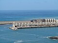
port


In Puerto de Tazacorte, the community owns the largest fishing and yachting port on the island with 340 berths for boats up to 20 meters in length and a ferry dock. In addition to fishing and sport boats, the port is also used by research vessels , fish farms and excursion boats. With a fleet of around 30 fishing boats (as of 2011), fishing in Puerto de Tazacorte has only local importance for the economy of La Palma. In 1997 the fishing fleet had the highest number of 40 vessels. The number of active fishermen fell from 44 in 1996 to 24 in 2000. Also due to the depletion of fish stocks in the region, the fish catch fell from 1200 tons in 1995 to 150 tons in 2000.
In 2003 the fish farming of sea bass (Lubina) and sea bream (Dorada) in large floating cages off the coast was launched to promote the fishing industry . Most of the 1,600 tons of fish farmed in 2006 went to mainland Spain as well as the USA, Canada and Russia.
Two notable incidents occurred during fish farming: In February 2010, during a heavy storm, around 200,000 young sea bass escaped from three net cages in front of the port of Tazacorte, which, if they had survived, allegedly would have endangered the local fish stocks ( mackerel , sardines and horse mackerel ) . To compensate the local fishermen, the farm is supposed to pay the fishermen a premium of 26 cents for each sea bass caught.
In October 2012, several anchored fish farming nets broke loose off the coast of Tazacorte and posed a threat to fishing and tourist boats. The cause is assumed to be the lack of maintenance of the nets due to the discontinuation of subsidies for fish farming.
EU funding
As part of the EU program for the Canary Islands, the port of Tazacorte was provided with a 176 meter long harbor wall from 2000 to 2006 with funding from the European Regional Development Fund ( ERDF ) amounting to 8.2 million euros. In a second construction phase from 2007 to 2013, a second harbor protection wall with a length of 400 meters was erected at a total cost of 54 million euros and an EU subsidy of 27 million euros.
The reason given for the second construction phase was: “Due to bad weather conditions, the port was only functional to a limited extent after the construction work was completed. As a result, it was decided to build an additional dam to protect the port and to expand the commercial zone. "
According to a communication from the Petitions Committee of the European Parliament, the main purpose of the port expansion of Tazacorte was to develop economic activity as a contribution to reducing the high unemployment rate of 25 percent. In particular, the export of bananas grown on the island, which are only competitive thanks to EU subsidies, should be encouraged. The port expansion could also create new transport links between Tazacorte and the islands of La Gomera and El Hierro. Previous attempts to build ferry connections to the neighboring islands and to attract cruise ships have failed, however.
In 2012, the EU criticized the oversized, only partially approved port expansion from ERDF funds. Originally, it called for demolition, but this was not enforced. The port expansion with an open area of over 26,000 m² for over 1000 parked cars is of no interest to cruise ships with a quay length of only 150 m and has not been used until today (2019). The construction of a bypass of Tazacorte, which began in 2012, as well as a connection to the port with several retaining walls and bridges, was soon stopped for financial reasons, but resumed in 2018. The costs for the three-lane 2.2 km long road amount to 15.7 million euros.

Puerto de Tazacorte 1999

Puerto de Tazacorte 2000

Puerto de Tazacorte 2007
Puerto de Tazacorte 2007 (view from Paseo del Litural)

Puerto de Tazacorte 2010
Puerto de Tazacorte 2012

Puerto de Tazacorte 2012

Puerto de Tazacorte 2014


Road network
The road network is well developed. Two bus lines connect Tazacorte with regular traffic with Los Llanos and with the municipalities in the northwest of the island. The LP-2 will be routed around the site from around 2021.
Local politics
In the 2015 local elections, the Unión Bagañete , which represents the interests of the banana producers , became the strongest force in the local council. It received an absolute majority with six out of eleven seats, followed by the PSOE with three seats.
Culture and sights
Festivals
As in many places in Spain, in Tazacorte, at the end of the carnival season, the burial of the sardine is celebrated by a procession of “wailing widows” and “mourners”.
Every year on July 16, the sailors hold a procession in honor of the patron saint Virgen del Carmen .
On September 29th the big festival in honor of the Archangel Michael , the patron saint of the church, patron saint of the city and the port of Tazacorte and all the inhabitants of La Palma takes place. The highlight is the unique dance of the Caballos Fufos , the hissing horses. Twenty horses - pipe frames clad in colored paper - dance through the streets, led by a giraffe.
Attractions
- The Church of San Miguel Arcángel in Tazacorte was built in 1513 on the site of the island's first pilgrimage chapel from 1492. In 1922 the church became a parish church. Among other things, the relics of the martyrdom of the 40 Jesuits are kept here (see section History).
- A large bronze statue of the Archangel Michael , framed by a fountain, sits in front of Tazacorte Town Hall. It was created in 2007 by the artists Luis Morera and Natan Teutsch. The archangel Michael , the patron saint of the island, is also included in the coat of arms of La Palma as defender of the church, carrying the sword.
- Historic stair quarter of Villa de Tazacorte.
- El Charco , the quarter below the church with the historic mansions Casa Massieu (art exhibitions often take place here), Casa Monteverde and Casa Díaz Pimienta as well as the Molino Abajo , Los Lavaderos and the aqueduct (see section History).
- The Museo del Plátano in El Charco , which opened in 2004 and is surrounded by a banana plantation, uses panels to show the history of banana plantations in the Canary Islands and in Tazacorte in particular. A large number of historical recordings of Tazacorte and this trade serve to illustrate.
- The Museo del Mojo , in the park area of the Museo del Plátano , shows the local spices and their use.
- The Casa Museo Doctor Morales honors the doctor and citizen of Tazacorte Manuel Morales Pérez (1902–1986), who did a great job fighting the plague in the 1920s. It is in close proximity to the church.
- Paseo del Litural is an unfinished coastal footpath , consisting of two short sections, along the steep coast of Tazacorte. One reaches the one section below El Charco through the banana plantations, where there is a broad view of the port of Puerto Tazacorte. From here a steep boton staircase leads to a secluded lava beach. The other section can be reached in San Borondón .
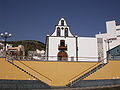
San Miguel Arcángel Church

Bronze figure of San Miguel de La Palma at the town hall.

Historic staircase district, above the church

Museo del Plátano
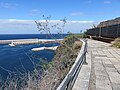
To reach the Paseo del Litural from El Charco .
To reach the Paseo del Litural of San Borondón .


Others
Named after Tazacorte engine cargo ship Tazacorte in 1952 by the Hamburg based Oldenburg-Portuguese Steamship Rhederei asked GmbH (OPDR) in service and was used until 1971 in the amniotic service to the Canary Islands. Then it was sold to the Guam-Guam Shipping Co. and sailed as the Golden Sea under the flag of Singapore . In 1973 it was sold to Taiwan for demolition.
literature
- Salvador González Vázques: Historia de Tazacorte 1492–1975 , Villa y Puerto de Tazacorte 2000, ISBN 8489692203
- Misael Pulido Acosta: Tazacorte, un pueblo, un mar, un amor , Villa y Puerto de Tazacorte 1992, ISBN 8479261021
- Miguel Medina y Quesada, Francisco A. Ossorio Acevedo: La independencia de Tazacorte , Villa y Puerto de Tazacorte 1992
- Ana Viña Brito: La cultura de azucar: Los ingenios de Argual y Tazacorte , Santa Cruz de La Palma 1994, ISBN 8460507106
- Luis Chacón Ortega: Tazacorte, La Palma , Villa y Puerto de Tazacorte 1969
- Juan Carlos Díaz Lorenzo: Tazacorte: Un puerto entre dos siglos. Gobierno de las Canarias 2003
Web links
swell
- ↑ Cifras oficiales de población resultantes de la revisión del Padrón municipal a 1 de enero . Population statistics from the Instituto Nacional de Estadística (population update).
- ↑ Alcalde-Presidente de la Villa y Puerto de Tazacorte , website Ayuntamiento de La Villa y Puerto de Tazacorte (accessed on July 19, 2015).
- ↑ The 1949 San Juan eruption , website of Rainer Olzem, qualified geologist (accessed on December 1, 2019)
- ↑ Hiking and leisure map La Palma (1: 30,000), Freytag & Berndt, Austria, 2017.
- ↑ Las cavidades volcánicas de los términos municipales de Los Llanos de Aridane y Tazacorte (La Palma, Islas Canarias) , F. Dumpiérrez, M. Fernández, O. Fernández, R. García, AJ González, F. Govantes, JM Hernández & M Muñoz, website Memoria digital de Canarias . Also contains the location and sectional drawings of the tubes. (accessed November 30, 2014)
- ↑ Tubo Volcánico de Todoque , website of Rainer Olzem, qualified geologist (accessed November 30, 2014)
- ↑ a b INEbase database of the Instituto Nacional de Estadística (accessed November 30, 2014)
- ↑ a b c d e f g h i j k l m Museo Historia del Plátano Tazacorte: Notes on the history of the banana plantations in Tazacorte. Loose-leaf collection, available in the museum
- ↑ El puerto de Tazacorte en los años de la autarquía , website La Palma, Isla Adentro by Juan Carlos Díaz Lorenzo, entry from November 8, 2009 (accessed November 30, 2014)
- ↑ a b Baedeker travel guide La Palma, El Hierro , online (accessed on November 30, 2014).
- ↑ New nudist beach on La Palma is very popular , Website Noticias7 , entry from July 30, 2014 (accessed on November 30, 2014)
- ↑ Dominik Josef Wölfel: Monumenta Linguae Canariae. Graz 1965, p. 741. For comparison: The name of the Moroccan city Zagora used to be Tzagurt , Tazakurt or Tazagourt (ⵜⴰⵣⴰⴳⵓⵔⵜ). Tazaghart is a 300 meter high flat mountain in Morocco, see location on mapcarta.com
- ↑ Comunidad de Aguas Privadas: Estatutos del Heredamiento de las Haciendas de Argual y Tazacorte. Barcelona 1967, p. VI.
- ↑ Jose Wangüemert y Poggio: El Almirante Don Francisco Díaz Pimienta y su época . Tazacorte 1990, p. 55 f.
- ↑ a b c d e f g h Salvador González Vázques: Historia de Tazacorte 1492–1975 , Villa y Puerto de Tazacorte 2000, ISBN 84-89692-20-3 , pp. 12f., 186–296, 404–409.
- ↑ a b Monumentos y Edificaciones , website of the Ayuntamiento de La Villa y Puerto de Tazacorte (accessed December 5, 2014).
- ↑ The Origins ( Memento of June 6, 2014 in the Internet Archive ), website of the Hotel Hacienda de Abajo (accessed on December 1, 2014)
- ↑ La Artillería de La Palma (1528-1860) Juan Tous Meliá, website Arte y Sociedad Revista de Investigacion (accessed on December 1, 2014)
- ↑ La historia militar en La Palma , website Palmeros en El Mundo (accessed on December 1, 2014)
- ↑ a b c The fabulous tale of the martyrs of Tazacorte ( Memento of September 22, 2010 in the Internet Archive ) on the Buen Viaje website (accessed on December 1, 2014)
- ↑ a b The Tazacorte Martyrs , website La Palma Island , entry from March 9, 2015 (accessed on December 21, 2015).
- ↑ Rural place with a nautical spirit ( memento of September 22, 2010 in the Internet Archive ) on the Buen Viaje website (accessed on December 1, 2014)
- ↑ a b c d El azúcar y su cultura en las islas atlánticas, 500 Años de La Palma y Flandes (1513–2013) , Vol. 1 , Jesus Pérez Morera on the Memorial Digital de Canarias website (accessed December 8, 2014)
- ↑ a b c d e El azúcar y su cultura en las islas atlánticas, 500 Años de La Palma y Flandes (1513–2013) , Vol. 2 , Jesus Pérez Morera on the Memorial Digital de Canarias website (accessed on December 1, 2014 )
- ↑ europlatano, Las Gabaceras ( Memento from December 15, 2014 in the Internet Archive ) (accessed December 13, 2014)
- ^ A b Sugar Islands: The Sugar Economy of Madeira and the Canaries, 1450–1650 , Alberto Vieira on the Secretaria Regional Da Educação e Recursos Humanos website (accessed December 1, 2014)
- ↑ a b c d Rolf Goetz: La Palma active vacation , Peter Meyer travel guide, 5th edition 2000, ISBN 3-922057-32-2 , pp. 53-59
- ↑ a b Historia de San Miguel de La Palma , website Palmeros en El Mundo (accessed on December 1, 2014)
- ↑ Familia Yanes Carrillo ( Memento of November 29, 2014 in the Internet Archive ), Website Palmeros en El Mundo (accessed on December 18, 2014)
- ^ Heterodoxia Ideologica y Accion Politica: Los Luchadores, de Esteban Beltran Blas Sánchez Dueñas, Universidad de Córdoba, 2011 (accessed December 1, 2014)
- ↑ Centenario del periódico Tazacorte: 15 de octubre de 1910 , website elapuron.com , entry from October 14, 2010 (accessed on December 1, 2014)
- ↑ a b c d Tazacorte durante el siglo XX , Salvador González Vázquez on the Biblioteca digital website (accessed on December 1, 2014)
- ↑ La Semana Roja en La Palma , Salvador González Vázquez on the Biblioteca digital website (accessed on December 1, 2014)
- ↑ a b c El Desarrollo de los Territorios Locales: El Municipio de Tazacorte, en La Palma , José-León García Rodríguez on the website of the Universidad de La Laguna (accessed on December 1, 2014)
- ↑ Poblaciones de derecho desde 1986 hasta 1995, 38045 Tazacorte , website of the Instituto Nacional de Estadística (accessed November 30, 2014).
- ↑ Series de población desde 1996, 38045 Tazacorte ( Memento of December 5, 2014 in the Internet Archive ), website of the Instituto Nacional de Estadística (accessed on November 30, 2014)
- ↑ Data from the municipality on the social structure (accessed on January 14, 2014)
- ↑ Cooperativas Unidas de La Palma website CUPALMA (accessed on December 1, 2014)
- ↑ Producción de Plátanos de Canarias comercializados , website of the Asociación de Organizaciones de Productores de Plátanos de Canarias (accessed December 1, 2014)
- ↑ Análisis de la potencialidad de las ayudas del IFOP y FEP Puerto pesquero de Tazacorte , Analysis of the potential of the fishing port of Tazacorte on the website of the Ministerio de Medio Ambiente y Media Rural y Marino (accessed on December 21, 2015).
- ↑ 200,000 fish escaped from fish farming , website Wochenblatt , entry from April 23, 2010 (accessed December 1, 2014)
- ↑ Danger for ships: abandoned fish farms ( memento from March 4, 2016 in the Internet Archive ), Tenerife Forum website , entry from October 24, 2012 (accessed on December 1, 2014)
- ↑ Parliamentary inquiries, May 9, 2012: EU-funded projects on the Canary Island of La Palma on the website of the European Parliament (accessed on December 1, 2014)
- ↑ Parliamentary questions, June 25, 2012: Answer by Mr Hahn on behalf of the Commission on the European Parliament's website (accessed on December 1, 2014)
- ↑ a b Communication from the Committee on Petitions on support for the outermost regions (Canary Islands) of 2 September 2010 on the website of the European Parliament (accessed on 1 December 2014)
- ↑ 20 months for the expansion of the port of Tazacorte on the Kanarenexpress website , entry from September 28, 2008 (accessed on December 1, 2014)
- ↑ La UE obliga a eliminar la ampliación del puerto deportivo de Tazacorte , El Día website , entry from January 4, 2012 (accessed December 21, 2015)
- ↑ Construction of the LP-2 Los Llanos-Tazacorte bypass on: la-palma.travel , March 1, 2019, accessed on October 13, 2019.
- ↑ Horarios ( Memento from December 4, 2014 in the Internet Archive ) on the Transportes Insular La Palma website (accessed on November 30, 2014)
- ↑ Local elections 2015 El País (accessed July 19, 2015)
- ^ Church of San Miguel , website of the Ayuntamiento de La Villa y Puerto de Tazacorte (accessed February 18, 2018).
- ↑ La Palma has the patron saint in bronze , Canary Express, Tazacorte, entry from October 20, 2007 (accessed on November 30, 2014)
- ↑ Casa Massieu Tazacorte, Publicado en Edificios Públicos , Website Obra Pública La Palma (accessed on January 3, 2015).
- ↑ Los Lavaderos , website of the Ayuntamiento de La Villa y Puerto de Tazacorte (accessed December 5, 2014).
- ↑ a b Museo del Plátano y Museo del Mojo , website of the Ayuntamiento de La Villa y Puerto de Tazacorte (accessed on February 18, 2018).
- ↑ Dr. Manuel Morales , website of the Ayuntamiento de La Villa y Puerto de Tazacorte (accessed February 18, 2018).
- ↑ Coastal hike , La Palma Travel, Visita al pueblo Villa de Tazacorte y paseos por los alrededores, June 17, 2016 (accessed on December 23, 2018).
- ↑ OPDR y el frutero alemán “Tazacorte” (1951–1971) , De la mar y los barcos, Juan Carlos Diaz Lorenzo, August 1, 2017 (accessed December 23, 2018).
- ↑ MS Tazacorte , The Ships List (accessed February 18, 2018).
- ↑ Juan Carlos Díaz Lorenzo: Tazacorte: Un puerto entre dos siglos. Gobierno de las Canarias 2003, pp. 170f.