San Andrés y Sauces
| San Andrés y Sauces parish | ||
|---|---|---|
| coat of arms | Map of the Canary Islands | |

|
|
|
| Basic data | ||
| Autonomous Community : | Canary Islands | |
| Province : | Santa Cruz de Tenerife | |
| Coordinates | 28 ° 48 ′ N , 17 ° 46 ′ W | |
| Height : | 260 msnm | |
| Area : | 42.75 km² | |
| Residents : | 4,141 (Jan 1, 2019) | |
| Population density : | 96.87 inhabitants / km² | |
| Postal code : | 38720 | |
| Municipality number ( INE ): | 38033 | |
| administration | ||
| Mayor : | Francisco Javier Paz Expósito ( PSOE ) | |
| Website : | www.sanandresysauces.es | |
| Location of the municipality | ||

|
||
San Andrés y Sauces (also called Villa y Ciudad de San Andrés y Sauces ) is one of the 14 communities on the Canary Island of La Palma .
geography
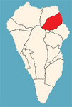
The municipality of San Andrés y Sauces is located in the northeast of La Palma and borders the municipality of Barlovento in the north and the municipality of Puntallana in the south . Both places are geographically separated from each other. One of the largest churches in La Palma, the Nuestra Señora de Montserrat from the 16th century, is located in the urban Los Sauces and houses Flemish art treasures. Opposite the church is the Antonio Herrera Park with its gardens.
The older town of San Andrés with its historic old town is located directly on the coast between large banana plantations. Just a few years after the island was conquered, San Andrés received city rights and for a long time was the administrative center in northeast La Palma. In the well-kept plaza is the church of San Andres Apostol , which was built in 1515 in honor of the patron saint.
To the north of San Andrés are the Charco Azul natural swimming pool and the small fishing port of Puerto Espíndola .
In the districts of the municipality of Las Lomadas and Los Galguitos are the pilgrimage chapels of San Pedro Apostol and San Juan Bautista , both from the period shortly after the Spanish conquest.
Los Tilos
The 511-hectare laurel forest Los Tilos in the town was by the 1983 UNESCO for Biosphere Reserve La Palma appointed. La Palma was the first Spanish island to receive this important international recognition. In 1998 the area was expanded to an area of 13,000 hectares, which covers about 16% of the island's area. The northeastern communities of the island, Barlovento, Puntallana, San Andrés y Sauces and partly also Santa Cruz de La Palma were involved.
The abundance of water in the Los Tilos region created the deep gorges of the Barranco del Agua with a lush vegetation that today consists of one of the largest continuous laurel forests on earth. In addition to large ferns, numerous species of laurel , some of them endemic, grow here . Since the spring water was drained off about 100 years ago in the upper area of the Barranco, this erosion process has largely come to a standstill. The deeply cut river bed that can be traversed still bears witness to this past process.
The Los Tilos area has a small visitor center, landscaped hiking trails and lookout points.
history
Cuevas del Tendal
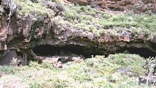
In the Barranco de San Juan of the municipality of San Andrés y Sauces there are the spacious Guanche caves Cuevas del Tendal with formerly 16 rooms of the residents and two collective grave caves ( necropolis ). There were several hut villages in the vicinity of the cave.
On the south side of the Barranco, the El Tendal information center was built, which is the third pre-Hispanic site on La Palma, alongside the Belmaco cave in Mazo and Zarcita Zarza in Garafía .
Sugar cane cultivation
Already shortly after the Spanish conquest of La Palma in the 16th century, large areas of sugar cane were grown in the fertile and water-rich areas of San Andrés y Sauces and in Argual and Tazacorte . San Andrés y Sauces had abundant water via the Río de los Sauces ( River from the Willows ). Experience with the already practiced sugar cane cultivation and processing on Madeira and Gran Canaria was used by the Dutch and Catalan landowners on La Palma. The export of the coveted sugar to Europe brought wealth to the landowners, which can still be seen in the stately mansions of San Andrés today.
The small port of Puerto Espíndola was specially created for the overseas shipping of sugar, as there was no navigable land connection to Santa Cruz with its port at the time .
With the cultivation of sugar beet in Europe in the 19th century, sugar cane production largely came to a standstill and took San Andrés an important source of income. However, sugar cane is still grown today in San Andrés and Barlovento for the distillation of rum .
The sugar cane production on La Palma was about 250 tons in 1914 in San Andrés and Barlovento and about 290 tons in Argual and Tazacorte . In 2003 around 150 tons of sugar cane were extracted in San Andrés and Barlovento.
A family business in San Andrés has been producing rum for several generations and operates a sugar cane mill and stills. The specialty of the rum is characterized by the "direct distillation" of the fresh sugar cane juice.
History and production processes are presented in the Sugar Cane and Rum Museum , which is located in the building of Destilerias Aldea .
economy
The main livelihood of the municipality is agriculture. The predominant cultivation product since the beginning of the 20th century has been the banana, whose plantations cover large areas of land in the municipality up to a cultivation height of 300 meters.
Population and places of the municipality
The population figures in brackets are from 2013.
- Los Sauces (2,317)
- San Andrés (267)
- Quinta Zoca (255)
- Hoya Grande (235)
- Garachico (249)
- Verada de Las Lomadas (225)
- Verada Bajamar (154)
- El Cardal (104)
- El Tanque (133)
- Llano El Pino (122)
- Ramirez (71)
- Orotava (73)
- Bermudez (77)
- Llano La Palma (62)
- San Juan (43)
- El Roque (42)
- San Pedro (28)
- Fuente Nueva (16)
Population development
The population has been falling almost continuously since the 1960s (1960–2013: –27.9%).
|
|
Web links
Individual evidence
- ↑ Cifras oficiales de población resultantes de la revisión del Padrón municipal a 1 de enero . Population statistics from the Instituto Nacional de Estadística (population update).
- ↑ a b c Rolf Goetz: La Palma, active vacation on the greenest of the Canary Islands . 5th edition. Peter Meyer travel guide, Frankfurt am Main 2000
- ↑ World Biosphere Reserve La Palma. In: lapalmabiosfera.es. Retrieved December 15, 2017 .
- ↑ Martin Macho: El conjunto prehistórico El Tendal es clave para conocer el pasado aborigen de las Islas. Canarias / La Palma 2012. El yacimiento estrella
- ^ Ayuntamiento de la Villa y Ciudad de San Andrés y Sauces, Casco histórico de la villa de San Andrés
- ^ Las Cuevas del Tendal
- ↑ Ayuntamiento de la Villa y Ciudad de San Andrés y Sauces
- ↑ José Luis Sánchez Perera: Los Ingenios Azucareros .
- ↑ El azúcar y su cultura en las islas atlánticas: escenarios, arquitecturas y organización espacial en los ingenios de caña dulce , Vol. 2.
- ^ Ines Dietrich: The sugar cane and rum museum of San Andrés. In: la-palma.travel. September 29, 2015. Retrieved October 29, 2017 .
- ↑ Historia de Destilerías Aldea en San Andrés y Sauces
- ↑ INEbase (database of the Instituto Nacional de Estadística)


