Puente de los Tilos
Coordinates: 28 ° 47 ′ 54 " N , 17 ° 46 ′ 16" W.
| Puente de los Tilos | ||
|---|---|---|
| use | Road traffic | |
| Crossing of | Barranco del Agua | |
| place | San Andrés y Sauces | |
| construction | Concrete arch bridge | |
| overall length | 319 m | |
| width | 12 m | |
| Longest span | 255 m | |
| Arrow height | 46.20 m | |
| Arrow ratio | 5.52 | |
| height | 150 m | |
| building-costs | € 5.4 million | |
| start of building | 2001 | |
| completion | 2004 | |
| planner | Santiago Perez-Fadon Martinez, José Emilio Herrero Benéitez, Juan José Sánchez Ramírez, Marcos Sánchez Sánchez | |
| location | ||
|
|
||
The Puente de Los Tilos is located in the municipality of San Andrés y Sauces in the northeast of the island of La Palma ( Canary Islands , Spain ), where it spans the Barranco del Agua at a height of 150 meters.
It is after the original UNESCO - Biosphere Reserve named in the mountains above the bridge, which because of its laurel forest was protected. In the meantime, the whole island has been declared a La Palma Biosphere Reserve .
The bridge is part of the two-lane main thoroughfare LP-1, which connects the capital of the island of Santa Cruz with the northern municipalities and was used by around 3,000 vehicles daily in 2005. When it was inaugurated, it was the largest concrete arch bridge in Europe
construction
The 319 m long and 12 m wide arch bridge consists of a large segment arch with an elevated roadway. The arch has a span of 255 m with an arrow height of 46.20 m, i.e. an arrow ratio of 5.52. It consists of a single-cell, rectangular, 6 m wide and 3 m high hollow box made of reinforced concrete .
On the arch, the roadway is elevated by 16 pillars with a center distance of 17 m, next to the arch there are two further pillars with a distance of 17 m and 15 m. The pillars have a rectangular hollow cross-section, the dimensions of which decrease from 4 × 1.30 m at the edge to 4 × 0.90 m in the apex.
The roadway girder consists of a composite of a 6.70 m wide grating made up of two steel longitudinal girders, which are stiffened by diagonal and transverse profiles, with a total of 12 m wide concrete slab.
The very inhomogeneous volcanic soil conditions had to be taken into account when laying the foundations at the ends of the arches and the abutments at the ends of the girder.
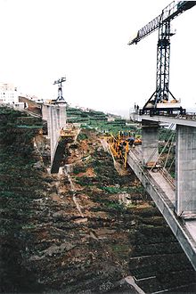
Construction of the bridge began in June 2001. The arch was erected using the cantilever method , in which the section to be concreted was guyed to the already completed pillars - and not, as is often the case, to auxiliary pylons. On June 10, 2004 the two halves of the arch met and were united to form the bridge. On November 3, 2004, static and dynamic load tests were carried out on the bridge with thirty trucks of 26 tons each. The speeds of the vehicles were 35 km / h and 65 km / h.
After 32 months of construction, the bridge was inaugurated on December 18, 2004.
literature
- S. Pérez-Fadón, JE Herrero, JJ Sánchez, M. Sánchez: El Arco de los Tilos en la Isla de La Palma (Canarias) - Los Tilos Arch on La Palma Island (Canary Islands) . In: Hormigón y Acero , No. 236, 2nd trimestre 2005, pp. 5–34 (Spanish, English)
Web links
- Tilos arch. In: Structurae
- Tilos Bridge on HighestBridges.com
- Image of the “Puente de Los Tilos” on the Spanish € 0.32 postage stamp
Individual evidence
- ↑ Reserva Mundial de la Biosfera La Palma / World Biosphere Reserve La Palma
- ↑ a b La Ministra de Fomento inaugura el viaducto de Los Tilos en la isla de La Palma, con el arco de mayor longitud de Europa sin apoyos.
- ↑ The height of the bridge over the valley floor is generally given as 150 m, only according to the official text about the inauguration it is 180 m high. From the contour lines in the topographic map 1: 20,000 in the Spanish geoportal for the Canary Islands IDECanarias , however, results in a height of 150 m.
- ↑ The technical information is the font of S. Pérez-Fadón, JE Herrero, JJ Sánchez, M. Sánchez: El Arco de los Tilos en la Isla de La Palma (Canarias) - Los Tilos Arch on La Palma Island (Canary Islands) . In: Hormigón y Acero , No. 236, 2nd Trimestre 2005, pp. 5-34.
- ↑ El puente de Los Tilos cumple una década , EL APURON, El Periodico digital de La Palma, December 20, 2014.


