Barlovento (La Palma)
| Barlovento municipality | ||
|---|---|---|
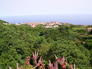
 View of the town of Barlovento
|
||
| coat of arms | Map of the Canary Islands | |

|
|
|
| Basic data | ||
| Autonomous Community : | Canary Islands | |
| Province : | Santa Cruz de Tenerife | |
| Island: | La Palma | |
| Coordinates | 28 ° 50 ′ N , 17 ° 48 ′ W | |
| Height : | 548 msnm | |
| Area : | 43.55 km² | |
| Residents : | 1,876 (Jan 1, 2019) | |
| Population density : | 43.08 inhabitants / km² | |
| Postal code : | E-38726 (Barlovento) E-38727 (Gallegos) |
|
| Municipality number ( INE ): | 38007 | |
| administration | ||
| Mayor : | Jacob Anís Qadri Hijazo ( PP ) | |
| Address of the municipal administration: | Plaza del Rosario | |
| Website : | www.ayuntamientodebarlovento.org | |
| Location of the municipality | ||

|
||
Barlovento ( German : windwards, windward, windward) is a municipality in the northeast of the Canary Island of La Palma , on the windward side of the island to the northeast trade wind . The place of the same name is the administrative center. The borders of Barloventos form the Barranco La Herradura in the south to San Andrés y Sauces and the Barranco de Franceses in the north to Garafía .
History and economic development
Before the Spanish conquest in the 15th century, Barlovento was called Tagaragre . The residents of the time, the Benahoaritas, ran cattle.
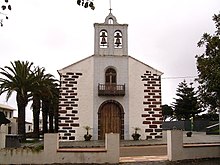
The church, Virgin del Rosario , built in 1581 formed the center of the later developing village of Barlovento. In 1678 Barlovento was able to break away from the dependency of the landlords in San Andrés y Sauces and became independent.
Directly influenced by the humid northeast trade winds, the mountainous and forested community is rich in water reserves at an altitude of 550 meters. The residents used the green areas for cattle breeding and agriculture. In the mid-nineteenth century, cactus plantations were established for the cultivation of cochineal dye . The need for the dye for the European textile industry alleviates the misery of the farmers and slowed down the migration to Cuba and Venezuela . With the construction of irrigation systems, sugar cane and banana plantations were created. Avocado and citrus fruit plantations followed later.
To facilitate the removal of the fruit, the port, Puerto Talavera, was built on the rocky coast in the area of the natural breakwater , through which the fruit was shipped to the island's capital Santa Cruz until well into the 20th century . Roads to the north of the island were built later.
Tourism as an economic factor is of little importance for Barlovento.
Laguna de Barlovento reservoir
To meet the water requirements for the banana plantations in the municipality of Barlovento, a reservoir Laguna de Barlovento with a capacity of 5.5 million m³ was built from 1971 to 1975 . For this purpose, a crater above Braloventos, 600 meters above sea level, was used, in which there was a natural pond and was used by the residents as a washing area.
In this dimension, the reservoir was the largest reservoir that has been built on the Canary Islands and in Spain to date. The approximately 250,000 m² floor area of the reservoir was sealed with a layer of clay, but the leakage losses were significantly higher than previously calculated. Even with the use of other clays, the building could not be used as a water reservoir. In 1990 it was decided to line the huge area of the storage tank wall with a waterproof PVC film. For reasons of cost, up to 25 meters of the 30 meter high embankment wall was occupied.
On April 16, 2011, the La Laguna de Barlovento reservoir suffered a severe rupture, from which thousands of cubic meters of water leaked and flowed to the sea through the adjacent banana plantations. Two houses were evacuated as a precaution, people were not harmed. Immediately before the break, a 3.9 magnitude earthquake was recorded that occurred 114 kilometers north of La Palma. Then an increased water drainage from the reservoir was determined, which increased up to 3.5 cubic meters of water per second. According to the Spanish Institute for Volcanology Canarias (Involcan), such a light earthquake cannot cause such damage to the reservoir.
When the storage basin is emptied, two large break points, lying next to each other, become visible, where the PVC film was torn and that the supporting soil under the film was no longer present. The two crack openings - about 20 meters apart - are 15 by 10 meters and 10 by 5 meters in size. It is believed that the load-bearing soil under the reservoir was softened and deformed by penetrating rainwater, which had led to excessive tension in the film.
Places of the municipality and population development
The population figures in brackets are from 2013.
- Barlovento (682 inhabitants)
- Las Cabezadas (378 inhabitants)
- La Cuesta (282 inhabitants)
- Gallegos (253 inhabitants)
- Lomo Machin (282 inhabitants)
- Las Paredes (97 inhabitants)
- La Tosca (62 inhabitants)
- La Palmita (31 inhabitants)
- Topaciegas (18 inhabitants)
Since the 1950s there has been a significant population decline (1950 to 2013: –34.7%).
|
|
Interesting places
- The single-nave church Virgin del Rosario , construction started in 1581, expanded in the 17th century, the bells are said to come from a Cuban sugar factory.
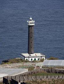
- The Faro de Punta Cumplida lighthouse , built in 1867 (shown in the Barlovento coat of arms).
- The old optics of Faro de Punta Cumplida, which was exhibited from 1992 to 2013 in the passenger terminal in the port of Santa Cruz de Tenerife , has returned to Barlovento and is exhibited in the town center.
- Dam lagoon of Barlovento (built in 1975), here there is also a leisure area with restaurants and playgrounds.
- Piscinas de La Fajana natural swimming pool (first used in 1976).
- Mirador de La Tosca with a view of the green north of the island.
- Center for handicrafts Las Mimbreras (the basket willows ), here baskets of all kinds are made.
Web links
swell
- ↑ Cifras oficiales de población resultantes de la revisión del Padrón municipal a 1 de enero . Population statistics from the Instituto Nacional de Estadística (population update).
- ↑ Barlovento - La Palma ihoppers.
- ↑ Un puerto al resguardo del morro de Talavera Juan Carlos Díaz Lorenzo, 2009.
- ↑ Puerto de Talavera GEQUO TRAVEL PORTAL.
- ↑ Rotura de La Laguna de Barlovento, April 26, 2011
- ↑ Sealing with geomembrane - The Barlovento basin
- ↑ Dam break after earthquake on La Palma nachrichten.at/apa April 17th, 2011.
- ↑ Un terremoto podría haber causado la rotura en La Laguna de Barlovento, April 17th, 2011
- ↑ El Instituto Volcanológico descarta relación entre seísmo y rotura de presa Television Canaria, April 18, 2011.
- ↑ Arreglar La Laguna de Barlovento costará 8.7 millones de euros ( Memento of the original from January 21, 2015 in the Internet Archive ) Info: The archive link was inserted automatically and has not yet been checked. Please check the original and archive link according to the instructions and then remove this notice. El Periodico digital La Palma, 07 de mayo de 2011.
- ↑ INEbase (database of the Instituto Nacional de Estadística)
- ↑ Barlovento recupera la antigua linterna del Faro de Punta Cumplida El Periodico Digital de La Palma, July 11, 2013.


