
Tijarafe
| Tijarafe municipality | |||
|---|---|---|---|
| coat of arms | Map of the Canary Islands | ||

|
|
||
| Basic data | |||
| Autonomous Community : | Canary Islands | ||
| Province : | Santa Cruz de Tenerife | ||
| Coordinates | 28 ° 42 ′ N , 17 ° 57 ′ W | ||
| Height : | 640 msnm | ||
| Area : | 53.76 km² | ||
| Residents : | 2,532 (Jan 1, 2019) | ||
| Population density : | 47.1 inhabitants / km² | ||
| Postal code : | 38780 | ||
| Municipality number ( INE ): | 38047 | ||
| administration | |||
| Website : | www.tijarafe.es | ||
| Location of the municipality | |||

|
|||

Tijarafe is one of the 14 communities on the Canary Island of La Palma . The name Tijarafe comes from the time of the Benahoaritas (before the Castilian conquest) and referred to the tribal area of the Tijarafe, which today consists of the communities of Tijarafe and Puntagorda . The administrative seat of the municipality is the place El Pueblo.
geography
Tijarafe is located in the north-western part of La Palma. The municipality borders the municipality of Puntagorda in the north and the municipalities of Tazacorte , Los Llanos and El Paso in the southeast , along the western edge of the Barranco de las Angustias and the Caldera de Taburiente National Park . The topography of the country rises steadily from the sea to the edge of the Caldera de Taburiente at about 2306 meters, the summit of Roque Palmero . The coast of Tijarafe is steep and inaccessible and extends over a length of 11.5 km, which is about 9.3 percent of the entire island circumference.
The land is cut by numerous ravines. The Barranco Jurado (Monumento Natural del Barranco del Jurado), southwest of the main town Tijarafe, was declared a natural monument in 1994 (see also list of protected areas in nature and landscape protection on La Palma ).


From Tijarafe a path leads through the Barranco Jurado to a small bay by the sea, the Prois de Candelaria , formerly a pirate's nest, today there are some fishermen's huts. A port on the coast of Tijarafe is mentioned as early as 1588, where ships could be loaded and unloaded and where goods could be transported to other communities on the island, for example for wheat and wood. The word "Proises" probably comes from Portuguese and means "tying the bow of a ship".
_01_ies.jpg)
The rugged coast of Tijarafe is the destination of excursion boats and sports boats, especially the cave "Cueva Bonita", which can only be reached by boat from the sea side. An accident occurred there in January 1997 when the excursion boat “María Anabel” drove into the cave with seven German tourists on board and was pressed against the ceiling of the cave by unexpectedly high waves and destroyed. The captain and a tourist were killed. The survivors had to spend the night in the cave on a small stretch of beach, as due to the high swell, rescue was only possible the following day when the sea was calmer.
A similar but not fatal accident occurred in September 2014 when a boat with two people in the “Cueva Bonita” was pushed against the ceiling of the cave by a wave and destroyed. The two people could not be freed until the following day in an extensive rescue operation involving helicopters and divers.
The climate in the region is very sunny and dry.
Parish parts

Except in the municipality of El Pueblo, there are no villages or hamlets in the municipality of Tijarafe, only scattered houses . In the municipality of El Pueblo there is only one village, this is also called El Pueblo. The population figures in brackets are as of 2013.
- El Pueblo (892, of which 538 in the village itself)
- La Punta (516)
- El Jesús (244)
- Aguatavar (221)
- Arecida (250)
- Tinizara (208)
- El Pinar (136)
- Bellido (91)
- La Costa (147)
- Amagar (71)
history
The historical development of Tijarafe was closely connected with the development of the ecclesiastical institution on La Palma after the Castilian conquest. It manifests itself in the construction of a small chapel around 1530. In its place, the Parroquía de Nuestra Señora de Candelaria church was built in 1567 . In 1584 the Ermita del Buen Jesús chapel was built.
The predominantly agricultural Tijarafe was already in the first half of the 16th century in the hands of a few large landowners residing outside the municipality. Grains such as wheat, rye and barley were grown, the yield of which could be increased by building terraces. The water supply in the rain-poor region was dependent on the collection of rainwater in cisterns . When there was no rain, there was a drought and with the crop failures, the farmers lacked livelihoods. Famine was the result.
In the 17th century Tijarafe was one of the most important producers of the island's grain production and brought the community a certain prosperity. In 1842 Tijarafe became an independent municipality and thus escaped control by the capital Santa Cruz de La Palma . In the same year the community received its first town hall. The first private school for 40 to 50 children was opened in 1845 and the first public school in 1915.
Over the centuries a mixture of mainland Spaniards , Portuguese , Benahoaritas and slaves (blacks and Moors) emerged who later received their freedom.
With the increase in population in the second half of the 19th century, the rural population became increasingly impoverished. This led to more emigration, especially to Cuba and Venezuela , in order to support the families left behind from there. From the 1930s onwards, the majority of the emigrants, mostly farmers, returned.
With increasing improvements in the water supply, bananas and tomatoes could be grown in the early 20th century. The connection to the "Barranco Minaderos" water canal of the Garafía municipality around 1960 contributed significantly to the water supply for Tijarafe's agriculture, which today employs 69 percent of the workforce.
The construction of the main road on La Palma (today the LP-1) connecting the localities in the 1940s brought about a significant improvement in the living conditions of the population and the community's economy.
In the tourism on La Palma, which began in the 1980s, the municipality takes part in the form of rural tourism , benefiting from its landscape character .

Population development
|
|
Culture
Tijarafe has two churches that date from the beginning of the Spanish occupation of the island. The parish church, Parroquía de Nuestra Señora de Candelaria, in the center of El Pueblo, was built between the 17th and 18th centuries and declared a Spanish cultural asset in 1996. The bell tower was built in 1686. The Ermita del Buen Jesús chapel in the El Jesús district was built in 1584 and declared a Spanish cultural asset in 1997.
The municipality has a museum and library (Museo Etnográfico - Biblioteca Municipal - Jose Luis Lorenzo Barreto) in El Pueblo, which are located in the building that was believed to be the old town hall of the municipality.
A festival known beyond the municipality is the Fiesta del Diablo , which takes place every September. During the event, a man dressed as a devil walks through the crowd with exploding fireworks.
The natives of La Palma, and especially the shepherds, had already mastered the art of moving with a long stick in the steep Barrancos. One sport, the Salto del Pastor , is still practiced today, including in Tijarafe. A graphic of the Salto del Pastor by Manuel Pereda de Castro is on the town hall of Tijarafe.

Iglesia Nuestra Senora de la Candelaria

Bell tower of the Iglesia Nuestra Senora de la Candelaria
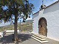
Ermita del Buen Jesús , on the south side of the Barranco Jurado , in the background El Pueblo

Calle la Luz in El Pueblo

El Salto del Pastor


economy
Water supply
In order to improve the water supply for the arid agricultural areas of Tijarafe and the Aridanetal (banana cultivation), the second largest water reservoir on the island, the "Balsa de Vicario", named after the town of El Vicario in Tijarafe, is being built in the municipality of Tijarafe. It is used to store excess water in winter and to irrigate agricultural areas with little rain in summer. This will increase the storage capacity of irrigation water on the island by 30 percent.


The storage facility is located between the districts of La Punta and Arecida, below the main road (LP-1) from Tijarafe and is to have a capacity of 1.6 million cubic meters. The other large water reservoirs on La Palma are "La Laguna de Barlovento" with 3.1 million cubic meters and "Balsa de Dos Pinos" between El Paso and Los Llanos with 0.4 million cubic meters of capacity.
The earthworks for the storage basin resulted in an excavation of one million cubic meters. The pool depth (height of the water level) is 25 meters. The pool floor is covered with a waterproof PVC membrane 1.5 mm thick. The power supply for the pumps is to be obtained from the storage tank through the force of gravity. The construction costs were set at 11 million euros.
Since construction work on the storage facility began in 2010, construction has been delayed for financial and geological reasons, among other things. Due to the very hard rock of the area, the necessary blasting to the overburden can only be carried out with a delay for environmental reasons. Construction is therefore expected to be completed by the end of 2017.
To feed in water, the storage basin is integrated into the island's existing hydraulic system, which consists of the "Túnel de Trasvase" in the Aridane Valley and the ring canal that extends from the northeast side via Barlovento , Garafía and Puntagorda to the Aridan Valley.
traffic
In terms of traffic, Tijarafe is connected to the municipalities of Los Llanos in the south and Puntagorda in the north via the LP-1 main road. The public passenger transport on La Palma via buses every hour (Bus / Guagua: Circunvalación Norte / North Bypass).
Web links
swell
- ↑ Cifras oficiales de población resultantes de la revisión del Padrón municipal a 1 de enero . Population statistics from the Instituto Nacional de Estadística (population update).
- ↑ a b c d e f Tijarafe , Website Palmeros en El Mundo, Ayuntamiento de Tijarafe, accessed on March 18, 2019.
- ↑ a b Graphic by Tijarafe , Instituto Canario de Estadistica (Entidades y núcleos PMH).
- ↑ a b R. Goetz: La Palma, active vacation on the greenest of the Canary Islands. 5th edition. Peter Meyer travel guide, Frankfurt am Main 2000.
- ↑ Monumento Natural del Barranco del Jurado ( Memento of the original from March 4, 2016 in the Internet Archive ) Info: The archive link was inserted automatically and has not yet been checked. Please check the original and archive link according to the instructions and then remove this notice. , Ayuntamiento de Tijarafe.
- ^ [1] , El oleaje arrojó la embarcación contra las paredes de la gruta marina, January 19, 1997.
- ↑ [2] , 3rd anniversary of the tragedy of the "Cave Beautiful".
- ↑ [3] , Two men saved by Cueva Bonita, September 22, 2014.
- ↑ INEbase (database of the Instituto Nacional de Estadística)
- ↑ a b [4] , Islas Canarias.
- ↑ CLARA RODRÍGUEZ GARCÍA, LA COMARCA NOROESTE DE LA PALMA: LA GRAN OLVIDADA DEL ESPACIO INSULAR
- ↑ Archived copy ( memento of the original from April 19, 2015 in the Internet Archive ) Info: The archive link was inserted automatically and has not yet been checked. Please check the original and archive link according to the instructions and then remove this notice. , Galería emplazada en “Barranco Minaderos”.
- ^ Iglesia de Nuestra Señora de Candelaria , Gobierno de Canarias, accessed March 18, 2019.
- ↑ Ermita del Buen Jesús , Fundación Canaria Reserva Mundial de la Biosfera La Palma, 2014, accessed on March 18, 2019.
- ↑ Ermita de El Buen Jesús , Gobierno de Canarias, accessed on March 18, 2019.
- ↑ a b New water storage basin for Tijarafe , La Palma Aktuell, August 2009.
- ↑ a b c El Gobierno aprueba mejoras en el proyecto de la Balsa de Vicario, en la Isla de La Palma , El Gobierno de Canarias, November 4th 2011.
- ↑ El Gobierno canario aprueba el Proyecto de la Balsa de Vicario (La Palma) , El Gobierno de Canarias, November 8th, 2009.
- ↑ La balsa de Vicario, otra obra pública que se eterniza en La Palma , ElApuron, June 28, 2016.
- ↑ 100 CIRCUNVALACION NORTE - bus timetable (Horario)