
Caldera de Taburiente National Park
| Parque nacional de la Caldera de Taburiente | |||
|---|---|---|---|
 |
|||
|
|||
| Location: | Canary Islands , Spain | ||
| Specialty: | Caldera | ||
| Next city: |
Los Llanos de Aridane El Paso |
||
| Surface: | 4,690 ha | ||
| Founding: | October 6, 1954 1981 Natura 2000-BSG (VS) |
||
| Visitors: | 424,832 (2011) | ||
 |
|||

The National Park Caldera de Taburiente , ( Spanish Parque Nacional de la Caldera de Taburiente ), is located on the Canary Island of La Palma . It forms a crater or caldera-like depression open to the west in the center of the island.
Protected areas
Since 1981 the area has also been a European bird sanctuary (ZEPA / SPA / BSG) in the Natura 2000 network ( ES0000043 ). Since 2012 it belongs to the La Palma Reserva Starlight .
geography
The Caldera de Taburiente measures around nine kilometers in diameter and has a circumference of around 28 kilometers. Its deepest point is about 430 meters above sea level. Sea level. The highest point of 2,426 meters above sea level. The crater rim reaches sea level in the north with the highest point of La Palma, the Roque de los Muchachos . On the eastern flank of the caldera rises the 1,854 meter high mountain Pico Bejenado . The water in the caldera flows over the Barranco de Las Angustias gorge ( Spanish : gorge of fears, anxiety ) in the west of the island into the Atlantic .
In 1954 the area was declared a national park, the Parque nacional de la Caldera de Taburiente . The national park can be accessed at Roque de Los Muchachos via the access road to the observatory , through the Barranco de Las Angustias via the access road from Los Llanos and from El Paso via the viewpoint La Cumbrecita , near which the ICONA park administration ( Instituto Nacional para la Conservación de la Naturaleza , National Institute for Nature Conservation) maintains a visitor center. Among other things, guided hikes are offered here.
geology
The Caldera de Taburiente is part of the volcanism process of La Palma. About two million years ago the shield volcano La Palmas, the Garafia volcano , broke through the sea surface from a depth of about 4000 meters and reached a height of about 2500 meters above sea level. Sea level. The volcanic cone collapsed 1.2 million years ago and poured out a debris avalanche in a south-westerly direction, which is still detectable today in the seabed of the island's flank by sonar measurements.
About a million years ago a new volcano emerged, the Taburiente volcano , which completely covered the Garafia volcano with its lava and should have reached a height of around 3000 meters. Between 125,000 and 500,000 years ago, the western flank of the Taburiente volcano collapsed , giving rise to the Caldera de Taburiente and the approximately ten kilometer long Cumbre Nueva mountain range . The northeastern edge of the Caldera de Taburiente, together with the Cumbre Nueva Ridge, forms the edge ( amphitheater ) of the Cumbre Nueva debris avalanche , the deposits of which are now 2500 to 4000 meters deep on the island's flank and cover the debris avalanche of the Garafia volcano . These deposits cover an area of approximately 780 square kilometers and have a volume of around 95 cubic kilometers.
As the land mass slid away, areas of the original sea volcano were exposed again, today's Los Llanos basin, from which the Bejenado volcano grew and covered this area again. Heavy erosion subsequently formed the Barranco de Las Angustias gorge .
At the bottom of this gorge and in the caldera up to 1000 meters above sea level, pillow lava or pillow lava can be found today . These shapes arise when lava emerges and solidifies underwater. These rocks from the submarine phase of volcanic formation ( seamount phase ) prove the uplift of the island in its early history, as was only the case in Fuerteventura in the Canary Islands .
The current structure of the Caldera de Taburiente is thus the product of the Cumbre Nueva debris avalanche, with the trailing edge on the northeastern edge of the Caldera de Taburiente and the Cumbre Nueva ridge, the later backfilling by the Bejenado volcano and the erosion of the Caldera and the Barrancos.
The question of how the Caldera de Taburiente was formed, through volcanism or erosion, has long been controversial in science. The Spanish word caldera (cauldron) is understood in geology to mean a large crater-shaped collapse structure of the volcano, which fell into the interior after a large magma chamber had been emptied . In 1825, the German geologist Leopold von Buch introduced the term Caldera de Taburiente. Various geologists, however, contradicted the theory of the caldera eruption and spoke out in favor of an erosion caldera .
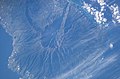
NASA satellite image
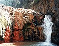
"Cascada colorada", the mineral-colored waterfall of the Río Almendro amargo
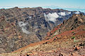
View from Roque de los Muchachos over the northern part of the caldera

Clouds in the caldera
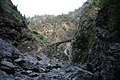
Barranco de las Angustias

Pillow lava

Summit of the Roque de Los Muchachos
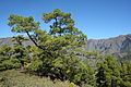
Pinus canariensis . Caldera de Taburiente


history
The crater was the last refuge for the natives of La Palma, the Auritas or Benahoaritas of the Acero tribe , when the conquest of Castile began in 1492 under Alonso Fernández de Lugo .

Idafe natural monument
In the middle of the crater there is a ridge between two gorges, on which a nearly one hundred meter high rock needle of volcanic basalt rises, the Roque Idafe ( 28.7125 N, 17.8807 W ). According to the indigenous people, this stone was of great importance. Animal sacrifices were made to him to prevent the rock from collapsing and a major catastrophe, as he was believed to be seen as a support between heaven and earth. However, archaeological finds in this area could not be made. The Roque Idafe was declared a Natural Monument in 1994.
Web links
Individual evidence
- ↑ Spanish Ministry of the Environment: Evolucion del numero de visitantes (1998–2011) ( Memento of the original from June 28, 2012 in the Internet Archive ) Info: The archive link was inserted automatically and has not yet been checked. Please check the original and archive link according to the instructions and then remove this notice.
- ↑ a b [1] , R. Olzem: Die Caldera de Taburiente, 2012.
- ↑ [2] , Roger Urgeles, Douglas G. Masson, Miquel Clanals, Anthony B. Watts, Tim Le Bas: Recurrent large-scale landsliding on the west flank of La Palma, Canary Islands, Journal of Geophysical Research, Vol. 104, 11th 1999 (measurement of the debris avalanche on the western flank of La Palma).
- ↑ [3] , JC Carracedo, ER Badiola, H. Guillou, J. de la Nuez and FJ Pérez Torrado: Geology and Volcanology of La Palma and El Hoerro , 2001.
- ^ DG Masson, AB Watts, MJR Gee, R. Urgeles, NC Mitchell, TP Le Bas and M. Canal: Slope failures on the flanks of the western Canary Islands . In: Earth Science Reviews . tape 57 , no. 1-2 , January 2002, ISSN 0012-8252 , p. 1-35 , doi : 10.1016 / S0012-8252 (01) 00069-1 (English).
- ↑ [4] , F. Neukirchen: La Palma - Ruta de los Volcanes & Ruta de la Cresteria (GR 131) , May 8, 2012.
- ↑ Archived copy ( memento of the original from August 26, 2014 in the Internet Archive ) Info: The archive link was inserted automatically and not yet checked. Please check the original and archive link according to the instructions and then remove this notice. , Curt Gagel, The Caldera of La Palma, Journal of the Society for Geography in Berlin, 1908.